Is there any credible, external visual evidence of an internal explosion?

Cheers!
Posted on 01/29/2013 1:35:14 PM PST by TXnMA
Reports of an explosion at Iran's Fordow nuclear facility have surfaced and are being both confirmed and denied by multiple sources.
The Jerusalem Post cites a report by Reza Kahlili that says: “The blast shook facilities within a radius of three miles. Security forces have enforced a no-traffic radius of 15 miles, and the Tehran- Qom highway was shut down for several hours after the blast.” Kahlili's report says the Fordow nuclear facility was severely damaged in an explosion and up to 240 workers trapped inside. The explosion was reportedly confined to the plant, suggesting that if it were an airstrike, it was highly localized. But this possibility is no more or less likely than sabotage, or an accident, assuming the explosion occurred at all.
>SNIP<
Iran's official news agency, says the same thing, with the IRNA, promptly denying the explosion, claiming the news was simply the result of the Western media-fueled "propoganda machine." That might have ended the story there, but The Times of London's Israel correspondent Sheera Frenkel is confirming the incident through her own independent sources: An explosion is believed to have damaged Iran’s Fordow nuclear facility, which is being used to enrich uranium, Israeli intelligence officials have told The Times. Sources in Tel Aviv said yesterday that they thought the explosion happened last week. The Israeli Government is investigating reports that it led to extensive structural damage and 200 workers had been trapped inside. One Israeli official said: “We are still in the preliminary stages of understanding what happened and how significant it is.” He did not know, he added, if the explosion was “sabotage or accident”, and refused to comment on reports that Israeli aircraft were seen near the facility at the time of the explosion.
(Excerpt) Read more at businessinsider.com ...
LOL! The technical term is, "Recliner with lap desk and laptop"
<GRIN>
It would seem like there was more than just that,....accoding to John Batchelor ...and the ex Iranian,....their was a blast that damaged the elevator and the stairways out of the TOMB.
Yeah, that's about where I come down. Thanks, TXnMA, for the interesting analysis.
I expect that those with real-time OHI (satellite or aircraft) probably know that answer. I was unable to validate the one (supposedly) post-blast image to my satisfaction using what is now publicly available.
Until there is suitable imagery in the public domain, I don't see how we can learn much more from available imagery.
Since each overflight/satellite pass takes a different track, each image has slightly different orientation, viewpoint, tilt, and perspective distortion. Manually georeferencing (point-to point matching) two different images is a laborious chore. I don't expect to be doing more of the same until images of the Fordo site verified to be from after the supposed explosion date are published on Google Earth or are published -- with time and date stamps -- by a credible source.
I have lots of other (totally unrelated) cartographic tasks in process using my currrent download of Google Earth data. Once I have them "put to bed" as KML files, I will clear all caches, re-boot GE, and see if suitable Fordo data has since been uploaded.
Until then, if anyone comes up with current Fordo data, please have them pass a copy along to me.
FYI, I just posted this to Business Insider's Facebook page:
~~~~~~~~~
Extensive image analysis of this photo showing an obvious dark "smudge" centered on Fordo's northern pair of tunnel entrances indicates that the "smudge" was added using image-processing software such as Photoshop.
http://static3.businessinsider.com/image/5106664b6bb3f7fb0300003d-618-464-400-300/fordow.jpg
1) Where did BI get that doctored photo?
2) Why did BI post it in the first place?
3) Why is it STILL being posted with an article that says there was NO explosion?
BI says there is no evidence of such an explosion. Why, then, does BI post fake evidence of an explosion?
Is BI going to post a retraction and apology?
It might not been an normal explosion.It could have been a "critical mass"
from not clearing yesterday's centrifuge.Years ago there was an incident at Hanford,
Washington involved with a centrifuge.
The problem was reports of an "earth-shaking explosion". A blast of that magnitude would almost certainly have vented. Hence I wasted time on analyzing what was most likely a bogus photo -- because we on FR deserved to know if it was -- or was not -- evidence of a vented explosion.
Oh, well, it was a useful exercise in doing something I hadn't done for a while -- and I polished up several useful analysis techniques using different software -- and we had some nice discussions...
Thanks for your work. I have been scouring the world press for any information. So far nothing new or from any new source. Unless the sinking of the $40 million Iranian platform was part of the Ops:)
NO cheers, unfortunately -- I might even pray for the poor bloody sods trapped down there if HF was released...
A day later and I'm having a problem seeing it...
Cheers!
How thick does one expect a coating of soot to be?
Cheers!
Are you claiming that ...(wait for it)
"Fordo lives" ?
Cheers!

Cheers!
That article was published 2.5 days ago...
Since then, several (including one with a statement by the IAEA) have been published saying nothing happened...
The first time I heard the term, “albedo” used (outside of classified discussions) was when the astronauts used it to describe the moon’s surface on TV...
Cheap imported Chinese straps. Oh well.
Bump to your post no. 29, UCANSEE2.
Whom ever was trapped down there....are all dead.
HF being a calcium seeker will turn their bones into rubber and slurry the rest.
there is nothing to save down there. The entire place is radio-contaminated, bio-contaminated and acid-contaminated.
(Deviation from orthogonality [tilting or exaggerating elevation as done for "3-D" viewing] can introduce errors that are unacceptable for accurate mapping.) ...as Apple learned with their aborted "Maps" app...LOL!
Of course, the published "after" image that I was analyzing was orthogonal, so that was the logical place to start. And - georeferencing it and "clamping it to ground" could best be done in the ortho view.
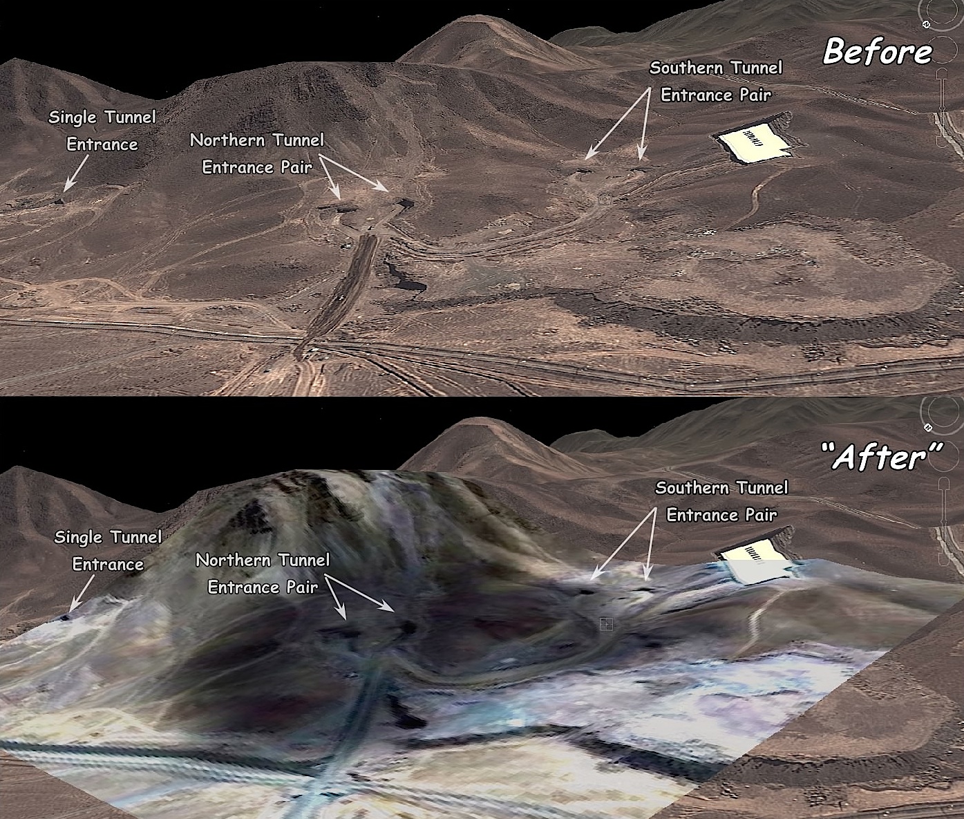
Hence, it wasn't until after I had published my [ortho view] analysis in #45, that I decided to "goof off" and do a 3-D "flyaround look-see" of the Fordo site with Google Earth:

~~~~~~~~
First of all, the site looks totally different in the 3-D view. If I had published the 3-D view first, there would have been far less misinterpretation and speculation about "craters", "bunker buster impact points", etc. by thread participants.
For example, the round, so-called "crater" area at upper left on the "ortho" views -- when viewed (at lower right) in the 3-D view -- is obviously a mound or "plateau" built up of "spoil" dirt and rock excavated from the subterranean chambers. (FWIW, I probably could calculate the volume of that "spoil pile" and come up with a prety fair estimation of the volume of the excavted spaces -- but no doubt, our "NTM" ("National Technical Means") folks have already done so with far better accuracy... '-)
~~~~~~~~
Secondly, the "After" view in 3-D makes it obvious that the "soot deposit" was an artificially-added imaging artifact:
~~~~~~~~~~~~~~
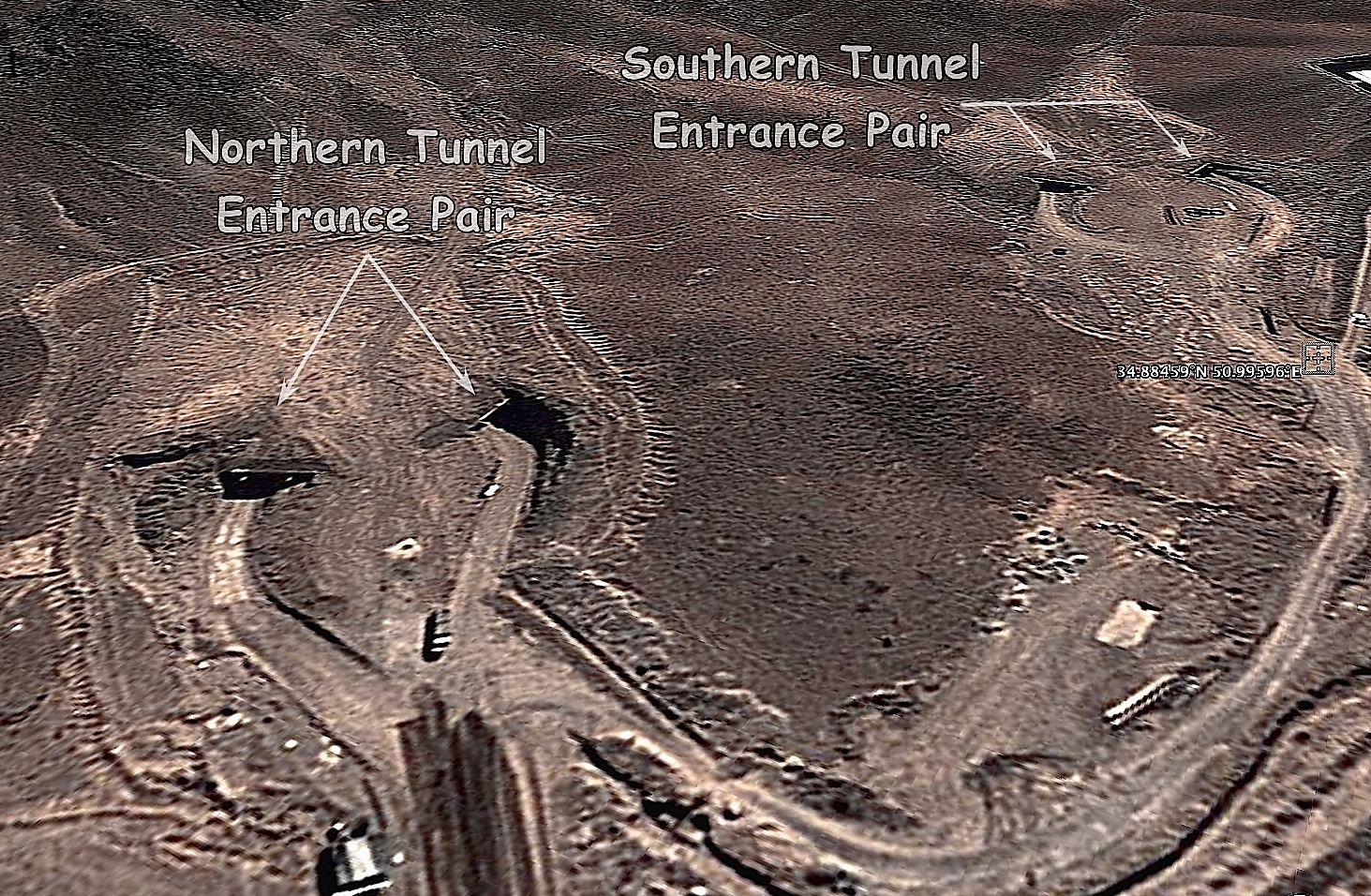
Finally, "just for grins", here is a (somewht enhanced) Google Earth "cruise missile view" of the tunnel entrances at Fordo:

Just think: if a 75 -year old USAF '-) veteran -- in his recliner, out in the Piney Woods boondocks of East Texas -- can produce this view from a website that anyone in the world can access... imagine what today's "NTM" troops are able to do with the "National Technical Means" they have available!! :-)
Pucker-time, Achmadinnerjacket!! <LOL!!!>
Disclaimer: Opinions posted on Free Republic are those of the individual posters and do not necessarily represent the opinion of Free Republic or its management. All materials posted herein are protected by copyright law and the exemption for fair use of copyrighted works.