
Posted on 09/12/2008 11:29:13 PM PDT by NautiNurse
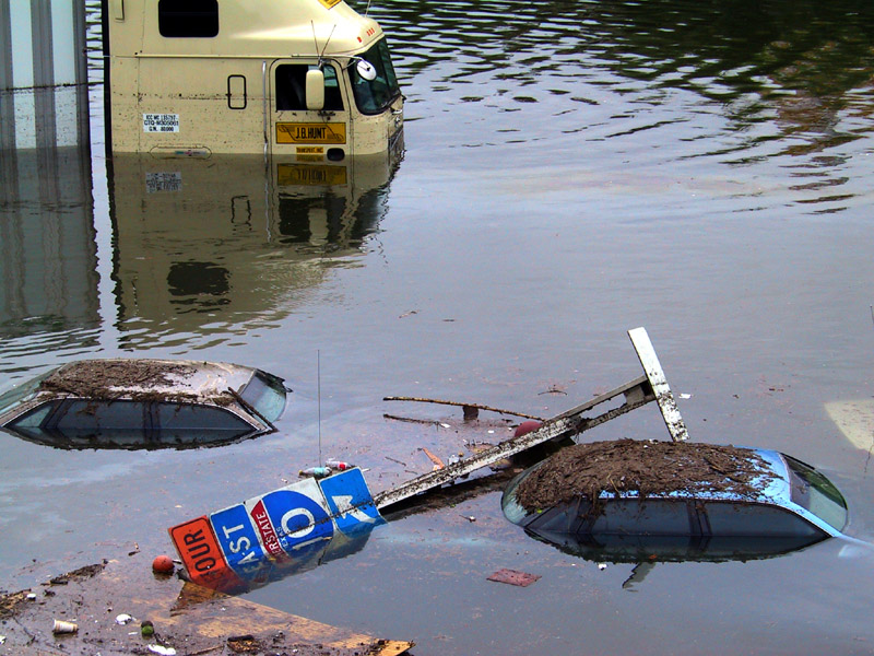
The eyewall of Hurricane Ike crossed Galveston Island in the early hours of Saturday morning. Reports indicate as many as 20,000 residents of Galveston Island chose not to evacuate as storm surge engulfed the island. The Freeport Chief of Police reported as many as 2000 residents did not evacuate as flood waters swamped coastal communities. There are widespread reports of power outages and coastal flooding throughout the Texas/Louisiana region. The U.S. Coast Guard received hundreds of calls Friday afternoon to rescue people stranded by flood waters along the barrier islands and Galveston Bay communities.
Multiple fires broke out in the Greater Houston area fueled by strong winds. Fire fighting efforts were hampered by flood waters. Brennan's Restaurant, a landmark in Houston, burned to the ground. A 584-foot freighter crippled in the Gulf of Mexico and its crew of 22 survived the storm after The U.S. Coast Guard was forced to abort rescue efforts Friday afternoon due to foul weather
Gulf Coast wholesale gasoline prices jumped to nearly $5 a gallon over fears that water and wind damage could keep the facilities closed for days or longer. Oil companies had shut down 97.5 percent of production in the Gulf of Mexico by Friday morning and were battening down refineries and petrochemical plants in an area that accounts for one-fifth of U.S. refining capacity.
Exxon Mobil reported evacuating workers from its Gulf Coast offshore platforms and onshore facilities in the anticipated path of Ike, shutting down daily production of about 36,000 barrels of oil and 270 million cubic feet of gas..
Public Advisory Updated every 3 hours
Discussion Updated every 6 hours
Buoy data: Western Gulf of Mexico
Houston/Galveston Long Range Radar
Corpus Christi Long Range Radar
Brownsville Long Range Radar
Lake Charles Long Range Radar
|
||||||||||||||||||||||||||||||||||||||||||||||||||||||||
Additional Resources:
Navy Tropical Cyclone
Storm Pulse Very cool site
KHOU Houston
ABC 13 News Houston
FOX News Houston
KPLC Lake Charles
KFDM 6 Beaumont/Port Arthur
KKBMT 12 Beaumont
KRIS-TV Corpus Christi
KZTV Corpus Christi
Brazoria County Emergency Management
Galveston County Emergency Management
Chambers Country Emergency Management
Liberty County Emergency Management
| Category | Wind Speed | Barometric Pressure | Storm Surge | Damage Potential |
|---|---|---|---|---|
| Tropical Depression |
< 39 mph < 34 kts |
Minimal | ||
| Tropical Storm |
39 - 73 mph 34 - 63 kts |
Minimal | ||
| Hurricane 1 (Weak) |
74 - 95 mph 64 - 82 kts |
28.94" or more 980.02 mb or more |
4.0' - 5.0' 1.2 m - 1.5 m |
Minimal damage to vegetation |
| Hurricane 2 (Moderate) |
96 - 110 mph 83 - 95 kts |
28.50" - 28.93" 965.12 mb - 979.68 mb |
6.0' - 8.0' 1.8 m - 2.4 m |
Moderate damage to houses |
| Hurricane 3 (Strong) |
111 - 130 mph 96 - 112 kts |
27.91" - 28.49" 945.14 mb - 964.78 mb |
9.0' - 12.0' 2.7 m - 3.7 m |
Extensive damage to small buildings |
| Hurricane 4 (Very strong) |
131 - 155 mph 113 - 135 kts |
27.17" - 27.90" 920.08 mb - 944.80 mb |
13.0' - 18.0' 3.9 m - 5.5 m |
Extreme structural damage |
| Hurricane 5 (Devastating) |
Greater than 155 mph Greater than 135 kts |
Less than 27.17" Less than 920.08 mb |
Greater than 18.0' Greater than 5.5m |
Catastrophic building failures possible |
|
|
Previous Threads:
Hurricane Ike Live Thread III
Hurricane Ike Live Thread II
Hurricane Ike Live Thread I
TS Hanna, Hurricane Ike & TS Josephine [Other than that, the tropics are calm]
Tropical Storms Hanna, Ike and Josephine, TD Gustav (Other than that, the tropics are calm)
Thanks for the tip. She should have listened to you.
why just strong “urging people to stay off streets”
why NOT a curfew ???
some people think URGING refers to everyone else.. NOT ME
The bill should also include a year of jail in the county pen, with bread and water rations and no TV
That little jaunt to the north just before landfall probably ended up saving Galveston. Had it been just a bit south, it pretty much would have all been under water.
Gulf Coast refineries appear to have escaped serious damage 10:41 AM Sat, Sep 13, 2008
Your Kemah image probably shows highway 146. If so, both good and bad news.
Bad news, that highway runs alongside a RR tracks, with near constant elevation from Texas City to north of Seabrook. The image confirms water over 146, which indicates pretty deep surge at Texas City and points west, possibly into LeMarque.
Heavily populated area, and all that debris came from what used to be buildings.
Good news, that image shows a low spot and the debris pile is finite in the distance. A few feet less surge there makes a huge difference for the above mentioned areas.
Fingers crossed.
Just struck me as odd...and hopeful. Remember after Katrina we were getting word from people who were doing the search and rescue with grim reports as they were going through houses on the coasts?
BATON ROUGE — The Louisiana Department of Wildlife and Fisheries (LDWF) began search and rescue (SAR) operations Friday, Sept. 12.
Total rescues for Sept. 12 were 173 from St. Tammany Parish to lower Terrebonne Parish. SAR teams deployed again this morning at 6:00 a.m. from a Forward Command Post established at Jennings and in the Houma area.
Teams responded with 29 boats to Hackberry and Big Lake Island. LDWF enforcement teams from central and northern Louisiana arrived at the Jennings Command Center early this morning with additional wildlife agent teams, 15 US Department of Interior boat crews and one Federal USAR team reporting at noon to assist and reinforce SAR operations as needed.
Total SAR personnel on a state level is 623, with 334 watercraft vehicles. These numbers include LDWF personnel and equipment, and personnel and equipment provided by the Louisiana National Guard, Federal USAR Teams and fish and! game state agencies from Arkansas, Kentucky, Ohio and Virginia. The Louisiana National Guard and U.S. Coast Guard will additionally provide aerial reconnaissance support for SAR missions. Flight assessments by the Louisiana National Guard and LDWF Enforcement personnel and US Coast Guard will determine the extent of SAR rescue activity needed.
For the latest information on Hurricanes Gustav and Ike, you can visit emergency.louisiana.gov or call the state’s emergency hotline at 1-866-288-2484 to listen to a recorded message with the most up-to-date information.
Information released by the Louisiana Department of Wildlife and Fisheries.


They say more than 4 million without power; the storm surge flooded 1,800 homes in Cameron Parish, Louisiana, and rescue officials initially couldn't get to them because of high winds; Many people in Orange County -- which lies on the Louisiana state line -- were stranded on rooftops and in attics because of storm surge
I am glad the khou coverage has very few commercials
cant recall many at all in over 12 hours watching it
Gondring wrote:
What software?
***************
Global Mapper, 3DEM and MicroDEM all allow sea level manipulation.
Most of them do. I get more concerned with the ones just to the left of me than those that have me as a direct hit. I don’t know why but look ....most of them curve. The index finger of God? :’)
Rescues begin amid Ike's destruction
Published September 13, 2008Emergency crews have not yet reported any fatalities as they make their way through high waters Saturday morning, rescuing injured survivors of Hurricane Ike. They have pulled people from high water and rescued people in the Fish Village area on the East End.
Winds and rain have destroyed the Balinese Room and MurDoch’s on the Seawall and severely damaged the Flagship hotel. The roof of city hall has collapsed, emergency responders said. Partial pieces of the 61st Street fishing pier are still intact, but the rest is gone.
A building near 63rd Street and Stewart Road is on fire, but firefighters are unsure if they can make it through the floodwaters to reach it. They said the burning building might be a church.
Firefighters are also trying to reach a large house fire that broke out last night at 51st Street and Avenue K. They’re not sure if it’s still burning, but last night the flames from the building reached into the sky.
At Ball High School, which was opened as a shelter of last resort, 12 Galveston firefighters are managing the injured. The city’s water system is not functioning.
Part of the roof of the San Luis Hotel was torn off and glass in the back of the building shattered. Water poured inside from the ceiling.
I should probably have wondered more about what you wrote when I first saw it right away. I’m sorry I didn’t even really think about it before.
“Hey, one of the models has Ike headed to Montana! Ya never know! ;-)”
After I ran across this comment a second time, it snapped out to me what the heck you were probably talking about ... (It would not normally surprise me that a model would be out in left field, but this one would have) ... I just went to look, and sure enough:
That track now “to Montana” is not a model. - It is a straight line extrapolation of the past 12 hours (I think) movement. ALL the models have this curling off to the NorthEast.
Similar experience here in northern Illinois. We got as much rain as the eye of Ike laid down.
I'm glad for the folks down there. Though a 20' surge was predicted, it sounds like it was only about 12'. A tragedy indeed. But, in most cases, not a catastrophe.
It seems many prayers have been answered.
For a long time my tagline read: "Never drink and FReep"...
My BIL is in Baytown. My husband hasn’t been able to reach him. They have a 2 story home though so I guess they are ok.

I-10 and I-45 interchange just north of downtown
LOL! Might be a good time to recycle that one.
Disclaimer: Opinions posted on Free Republic are those of the individual posters and do not necessarily represent the opinion of Free Republic or its management. All materials posted herein are protected by copyright law and the exemption for fair use of copyrighted works.