
Posted on 09/12/2008 11:29:13 PM PDT by NautiNurse
The eyewall of Hurricane Ike crossed Galveston Island in the early hours of Saturday morning. Reports indicate as many as 20,000 residents of Galveston Island chose not to evacuate as storm surge engulfed the island. The Freeport Chief of Police reported as many as 2000 residents did not evacuate as flood waters swamped coastal communities. There are widespread reports of power outages and coastal flooding throughout the Texas/Louisiana region. The U.S. Coast Guard received hundreds of calls Friday afternoon to rescue people stranded by flood waters along the barrier islands and Galveston Bay communities.
Multiple fires broke out in the Greater Houston area fueled by strong winds. Fire fighting efforts were hampered by flood waters. Brennan's Restaurant, a landmark in Houston, burned to the ground. A 584-foot freighter crippled in the Gulf of Mexico and its crew of 22 survived the storm after The U.S. Coast Guard was forced to abort rescue efforts Friday afternoon due to foul weather
Gulf Coast wholesale gasoline prices jumped to nearly $5 a gallon over fears that water and wind damage could keep the facilities closed for days or longer. Oil companies had shut down 97.5 percent of production in the Gulf of Mexico by Friday morning and were battening down refineries and petrochemical plants in an area that accounts for one-fifth of U.S. refining capacity.
Exxon Mobil reported evacuating workers from its Gulf Coast offshore platforms and onshore facilities in the anticipated path of Ike, shutting down daily production of about 36,000 barrels of oil and 270 million cubic feet of gas..
Public Advisory Updated every 3 hours
Discussion Updated every 6 hours
Buoy data: Western Gulf of Mexico
Houston/Galveston Long Range Radar
Corpus Christi Long Range Radar
Brownsville Long Range Radar
Lake Charles Long Range Radar
|
||||||||||||||||||||||||||||||||||||||||||||||||||||||||
Additional Resources:
Navy Tropical Cyclone
Storm Pulse Very cool site
KHOU Houston
ABC 13 News Houston
FOX News Houston
KPLC Lake Charles
KFDM 6 Beaumont/Port Arthur
KKBMT 12 Beaumont
KRIS-TV Corpus Christi
KZTV Corpus Christi
Brazoria County Emergency Management
Galveston County Emergency Management
Chambers Country Emergency Management
Liberty County Emergency Management
| Category | Wind Speed | Barometric Pressure | Storm Surge | Damage Potential |
|---|---|---|---|---|
| Tropical Depression |
< 39 mph < 34 kts |
Minimal | ||
| Tropical Storm |
39 - 73 mph 34 - 63 kts |
Minimal | ||
| Hurricane 1 (Weak) |
74 - 95 mph 64 - 82 kts |
28.94" or more 980.02 mb or more |
4.0' - 5.0' 1.2 m - 1.5 m |
Minimal damage to vegetation |
| Hurricane 2 (Moderate) |
96 - 110 mph 83 - 95 kts |
28.50" - 28.93" 965.12 mb - 979.68 mb |
6.0' - 8.0' 1.8 m - 2.4 m |
Moderate damage to houses |
| Hurricane 3 (Strong) |
111 - 130 mph 96 - 112 kts |
27.91" - 28.49" 945.14 mb - 964.78 mb |
9.0' - 12.0' 2.7 m - 3.7 m |
Extensive damage to small buildings |
| Hurricane 4 (Very strong) |
131 - 155 mph 113 - 135 kts |
27.17" - 27.90" 920.08 mb - 944.80 mb |
13.0' - 18.0' 3.9 m - 5.5 m |
Extreme structural damage |
| Hurricane 5 (Devastating) |
Greater than 155 mph Greater than 135 kts |
Less than 27.17" Less than 920.08 mb |
Greater than 18.0' Greater than 5.5m |
Catastrophic building failures possible |
|
|
Previous Threads:
Hurricane Ike Live Thread III
Hurricane Ike Live Thread II
Hurricane Ike Live Thread I
TS Hanna, Hurricane Ike & TS Josephine [Other than that, the tropics are calm]
Tropical Storms Hanna, Ike and Josephine, TD Gustav (Other than that, the tropics are calm)
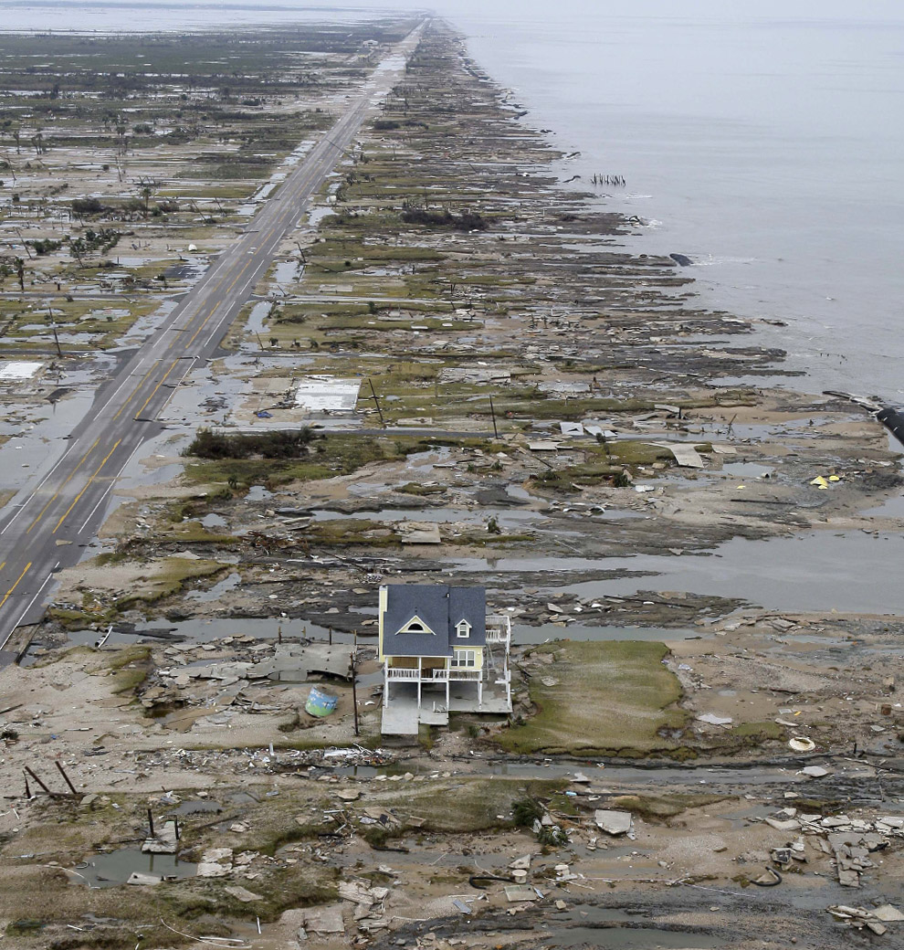
Yes that is it... You can see the blue thing to the left of the house (go back to the large picture of the house)
So the house is up past Rollover Point
Hmm .. and it looks like it was behind a GeoTube.


Still astounding, no matter how many times I see it.
Sorry for the double post
Rollover Point = Rollover Pass
So the mass of Land you see in the upper left corner (is that large chuck of land east of Boliva (sp) Penn.
So, the Pass isn’t really a pass thru .. from the Gulf inland.
You see paved highway right there.
Right... The large satellite picture shows the bridge over the pass (relief water channel) as being damaged - buckled) but I don’t believe it is a lift bridge for boats and such.
Slideshow
****
http://www.nytimes.com/slideshow/2008/09/15/us/0916-IKE_index.html
Heroes with utility trucks, others with airboats,
more herding cattle on horseback. God bless them all.
Make sure you see the Crystal Beach before and after pics.
It’s all so sad.

To my tired eyes, it doesn’t seem like
the same plot of land as in my pic above.
But that could just be the hour and me.
I don’t see all the flattened debris all
around it, with that one tallish home
sticking out from the rest.
I’ll check your latest tomorrow .. time to
get flat, with prayers on my pillow for all
those suffering souls.
Night.
night Starwise
“There has to be something else special about thisone house.”
Another poster suggested that unlike most houses which are nailed to their pilings, this one may have been bolted. I hope the construction code people give this house a good going over for future advice and legislation.
Here are some street maps of the whole Bolivar Peninsula
You can see the Rollover Pass on this one (this is the east side of the Peninsula) - the house sits on the right side (east) of the Rollover Pass and probably sits on what was Hebert Street.)
The left side of the map is west and right side of the map is east. The bottom of the map goes to the gulf and top of the map goes to the east bay of Galveston Bay.
http://www.bolivarchamber.org/portals/0/BolivarPeninsulaRight.pdf
Here is the west side map of Bolivar Peninsula (closest to Galveston Island)
http://www.bolivarchamber.org/portals/0/BolivarPeninsulaLeft.pdf (you can see Rollover Pass to the far right side of this map also.)
This picture shows the house to the east of Rollover Pass. (you can see the blue thing to the left of the house)
http://ngs.woc.noaa.gov/storms/ike/geo-C25883946.jpg
This picture is pointed directly east (towards High Island)
(notice the blue thing to the left of the house)
http://cache.boston.com/universal/site_graphics/blogs/bigpicture/ike_09_15/ike11.jpg
This picture is of Rollover Pass but is taken from the east looking west towards Galveston Island.
http://www.bolivarchamber.org/Portals/0/rolloverpassaerial.jpg
(the house would be on the left side of the road towards the gulf and close to the Rollover Pass as shown in this picture if it was built and standing when this picture was taken)
If you compare this picture (even though they are taken at different angles you can see how much was wiped out)
http://www.bolivarchamber.org/Portals/0/rolloverpassaerial.jpg (looking west)
http://cache.boston.com/universal/site_graphics/blogs/bigpicture/ike_09_15/ike11.jpg (looking east and taken just east of the Rollover Pass)
No problems on this end, jut setting the record straight.
While I’m here, I don’t think those are sat images, high altitude aerial instead. Seen those collections before, after Katrina and again after Rita and memory seems to tell me they were aerials.
It happens a lot. I was amazed reading about people like that in the 1938 hurricane. All i can figure is that people washed off barrier islands in hurricanes find enough debris to ride on till they get to the mainland. Funny thing there too, they all seem to clump together on landing. Guess the current, even though hurricane-chaotic, takes them all the same general direction and dumps them off close by.
http://www.bolivarchamber.org/portals/0/BolivarPeninsulaRight.pdf
http://www.bolivarchamber.org/portals/0/BolivarPeninsulaLeft.pdf
Bolivar Peninsula Satellite Photos (click on the yellow boxes for a closer look)
http://ngs.woc.noaa.gov/ike/29094D6_IKE.HTM
http://ngs.woc.noaa.gov/ike/29094D5_IKE.HTM
http://ngs.woc.noaa.gov/ike/29094E5_IKE.HTM
http://ngs.woc.noaa.gov/ike/29094E4_IKE.HTM
You hang in there. You’re already doing the one best thing you can, seeing the glass as being half full.
Keep it up, ask if you need something.
In Katrina, Louisiana lost about 1,500 people. I’m hoping that the tally in Texas comes nowhere near that number.
Disclaimer: Opinions posted on Free Republic are those of the individual posters and do not necessarily represent the opinion of Free Republic or its management. All materials posted herein are protected by copyright law and the exemption for fair use of copyrighted works.