To my tired eyes, it doesn’t seem like
the same plot of land as in my pic above.
But that could just be the hour and me.
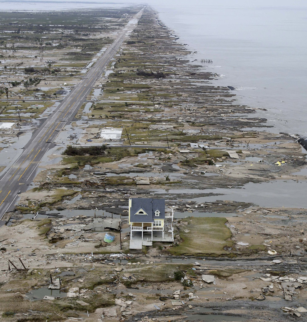
I don’t see all the flattened debris all
around it, with that one tallish home
sticking out from the rest.
I’ll check your latest tomorrow .. time to
get flat, with prayers on my pillow for all
those suffering souls.
Night.
night Starwise
Here are some street maps of the whole Bolivar Peninsula
You can see the Rollover Pass on this one (this is the east side of the Peninsula) - the house sits on the right side (east) of the Rollover Pass and probably sits on what was Hebert Street.)
The left side of the map is west and right side of the map is east. The bottom of the map goes to the gulf and top of the map goes to the east bay of Galveston Bay.
http://www.bolivarchamber.org/portals/0/BolivarPeninsulaRight.pdf
Here is the west side map of Bolivar Peninsula (closest to Galveston Island)
http://www.bolivarchamber.org/portals/0/BolivarPeninsulaLeft.pdf (you can see Rollover Pass to the far right side of this map also.)
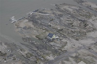
This picture shows the house to the east of Rollover Pass. (you can see the blue thing to the left of the house)
http://ngs.woc.noaa.gov/storms/ike/geo-C25883946.jpg
This picture is pointed directly east (towards High Island)
(notice the blue thing to the left of the house)
http://cache.boston.com/universal/site_graphics/blogs/bigpicture/ike_09_15/ike11.jpg
This picture is of Rollover Pass but is taken from the east looking west towards Galveston Island.
http://www.bolivarchamber.org/Portals/0/rolloverpassaerial.jpg
(the house would be on the left side of the road towards the gulf and close to the Rollover Pass as shown in this picture if it was built and standing when this picture was taken)
If you compare this picture (even though they are taken at different angles you can see how much was wiped out)
http://www.bolivarchamber.org/Portals/0/rolloverpassaerial.jpg (looking west)
http://cache.boston.com/universal/site_graphics/blogs/bigpicture/ike_09_15/ike11.jpg (looking east and taken just east of the Rollover Pass)
http://www.bolivarchamber.org/portals/0/BolivarPeninsulaRight.pdf
http://www.bolivarchamber.org/portals/0/BolivarPeninsulaLeft.pdf
Bolivar Peninsula Satellite Photos (click on the yellow boxes for a closer look)
http://ngs.woc.noaa.gov/ike/29094D6_IKE.HTM
http://ngs.woc.noaa.gov/ike/29094D5_IKE.HTM
http://ngs.woc.noaa.gov/ike/29094E5_IKE.HTM
http://ngs.woc.noaa.gov/ike/29094E4_IKE.HTM
I don’t know if have this info or not...
Bolivar Peninsula stretches lazily along the Gulf of Mexico for 27 miles. At it’s widest point between Crystal Beach and Caplen it’s 3.5 miles wide, and at it’s narrowest point in the Rollover Pass area it’s 1/4 mile wide. Although classified as a peninsula, it’s actually a barrier Island, and is accessible by land from a bridge over rollover pass to the mainland through southern Chambers County.
Bolivar’s five residential communities include: Crystal Beach, Port Bolivar, Caplen, Gilchrist and High Island. The population more than doubles during the summer months as owners of beach homes and tourists arrive to enjoy the beach, sun, bay sunsets, fishing, relaxation and the many attractions of the Bolivar Peninsula “Island”.
In 2000 the population of people living on the Peninsula was nearly 4,000.
Picture of Crystal Beach on Bolivar Peninsula Before and After
http://graphics8.nytimes.com/images/2008/09/15/us/16ike_5a.jpg
here is the backside of the last standing house - you can see the Rollover Pass canal (gulf side of the canal) in the right hand corner of the picture (the gulf side is on the left corner of the picture - the house front faces towards the west to Galveston Island)
http://www.jakeabby.com/cb/gilchrist2.jpg
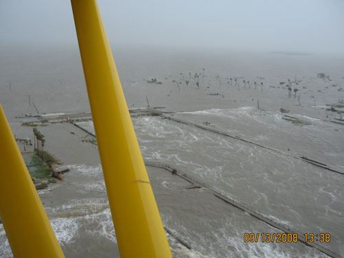
Here is a very early picture of the Rollover Pass Bridge before the water went down (the bridge is barely noticable but it is behind the 2 yellow poles on the plane) you are looking out towards the gulf in this picture. The last house standing would be to the left and is just out view in this picture. You can see the canal wall tops just barely in the photo also. There was at least one group of people that actually walked through here trying to make it to higher ground during the thick of it. They ended up at High Island which is to the left and few miles away.
http://www.jakeabby.com/cb/398.jpg