
Posted on 09/12/2008 11:29:13 PM PDT by NautiNurse
The eyewall of Hurricane Ike crossed Galveston Island in the early hours of Saturday morning. Reports indicate as many as 20,000 residents of Galveston Island chose not to evacuate as storm surge engulfed the island. The Freeport Chief of Police reported as many as 2000 residents did not evacuate as flood waters swamped coastal communities. There are widespread reports of power outages and coastal flooding throughout the Texas/Louisiana region. The U.S. Coast Guard received hundreds of calls Friday afternoon to rescue people stranded by flood waters along the barrier islands and Galveston Bay communities.
Multiple fires broke out in the Greater Houston area fueled by strong winds. Fire fighting efforts were hampered by flood waters. Brennan's Restaurant, a landmark in Houston, burned to the ground. A 584-foot freighter crippled in the Gulf of Mexico and its crew of 22 survived the storm after The U.S. Coast Guard was forced to abort rescue efforts Friday afternoon due to foul weather
Gulf Coast wholesale gasoline prices jumped to nearly $5 a gallon over fears that water and wind damage could keep the facilities closed for days or longer. Oil companies had shut down 97.5 percent of production in the Gulf of Mexico by Friday morning and were battening down refineries and petrochemical plants in an area that accounts for one-fifth of U.S. refining capacity.
Exxon Mobil reported evacuating workers from its Gulf Coast offshore platforms and onshore facilities in the anticipated path of Ike, shutting down daily production of about 36,000 barrels of oil and 270 million cubic feet of gas..
Public Advisory Updated every 3 hours
Discussion Updated every 6 hours
Buoy data: Western Gulf of Mexico
Houston/Galveston Long Range Radar
Corpus Christi Long Range Radar
Brownsville Long Range Radar
Lake Charles Long Range Radar
|
||||||||||||||||||||||||||||||||||||||||||||||||||||||||
Additional Resources:
Navy Tropical Cyclone
Storm Pulse Very cool site
KHOU Houston
ABC 13 News Houston
FOX News Houston
KPLC Lake Charles
KFDM 6 Beaumont/Port Arthur
KKBMT 12 Beaumont
KRIS-TV Corpus Christi
KZTV Corpus Christi
Brazoria County Emergency Management
Galveston County Emergency Management
Chambers Country Emergency Management
Liberty County Emergency Management
| Category | Wind Speed | Barometric Pressure | Storm Surge | Damage Potential |
|---|---|---|---|---|
| Tropical Depression |
< 39 mph < 34 kts |
Minimal | ||
| Tropical Storm |
39 - 73 mph 34 - 63 kts |
Minimal | ||
| Hurricane 1 (Weak) |
74 - 95 mph 64 - 82 kts |
28.94" or more 980.02 mb or more |
4.0' - 5.0' 1.2 m - 1.5 m |
Minimal damage to vegetation |
| Hurricane 2 (Moderate) |
96 - 110 mph 83 - 95 kts |
28.50" - 28.93" 965.12 mb - 979.68 mb |
6.0' - 8.0' 1.8 m - 2.4 m |
Moderate damage to houses |
| Hurricane 3 (Strong) |
111 - 130 mph 96 - 112 kts |
27.91" - 28.49" 945.14 mb - 964.78 mb |
9.0' - 12.0' 2.7 m - 3.7 m |
Extensive damage to small buildings |
| Hurricane 4 (Very strong) |
131 - 155 mph 113 - 135 kts |
27.17" - 27.90" 920.08 mb - 944.80 mb |
13.0' - 18.0' 3.9 m - 5.5 m |
Extreme structural damage |
| Hurricane 5 (Devastating) |
Greater than 155 mph Greater than 135 kts |
Less than 27.17" Less than 920.08 mb |
Greater than 18.0' Greater than 5.5m |
Catastrophic building failures possible |
|
|
Previous Threads:
Hurricane Ike Live Thread III
Hurricane Ike Live Thread II
Hurricane Ike Live Thread I
TS Hanna, Hurricane Ike & TS Josephine [Other than that, the tropics are calm]
Tropical Storms Hanna, Ike and Josephine, TD Gustav (Other than that, the tropics are calm)
This is Crystal Beach...
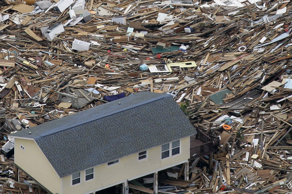
It makes you wonder if there are any bodies in this mess.
http://cache.boston.com/universal/site_graphics/blogs/bigpicture/ike_09_15/ike13.jpg
it is from this series of pictures
http://www.boston.com/bigpicture/2008/09/the_short_but_eventful_life_of.html
“... hump in the highway like this?”
It’s a bridge. I think that’s Surfside. If I’m right, you go west off Galveston, pay the toll at San Luis, go way down to SS, turn right at 332 and there is that shot. (Usually it has less water on the road.)
I didn’t post the photo credited to me.
The photo Nauti posted IS NOT a hoax.
Those damage levels are CONFIRMED by numerous other aerial grid photos.
Manmade structures on the eastern reaches of Bolivar Peninsula, for the most part, no longer exist.
If you look at that house, you can see why it survived when others didn’t. Most were up on stilts. The stilts offer little resistance to surge and fare well. But when the surge reaches the main structure, it either floats off the stilts and then gets beat to death, or else get smashed off the stilts, end of story.
Another prime method of failure, is when the sand around and under the stilts gets washed away, with predictable results for the house resting on them.
That house has a full concrete slab at grade level around and over the stilts, no washing, no scouring, stilts remain structurally viable much longer than stilts without a slab to protect them.
I’ll bet $500 that they took one other critical step in the construction of that house too, because the slab costs big bucks, and this costs very little in comparison.
Most people depend mostly on gravity to hold structures down.
A very few go the extra step and bolt it down. Bolted structures resist upthrusts orders of magnitude better than gravity held structures.
Bolts are cheap. Forces strong enough to lift a house against gravity suck. Failure to bolt is a mystery to me.
Streaming Houston channel 13, reporter around Gilchrist says ‘nobody wants to talk about fatalities’.
Our power went out Saturday morning at about 4:00am and just came back on at 8:00pm a few minutes ago!
Lots of work to catch up on.
Hopefully this ain’t a false alarm just to tease us!
Yes, there are bodies in debris piles like that. Those are probably the only bodies that will be found, everything else was swept into the bay and predators will make short ork of them.
That said, there may be one body, thousands of bodies, or somewhere in between.
We don’t know yet, but I can promise you this. In a day or two, search dogs will have zero problems finding the dead.
Welcome back! Thanks for checking in. A good number of FReepers got their power turned on today. Hooray!
Whoo Hoo ! The zombie looters didn;t get Eeeek ! Good Deal !
Glad ya got life back almost to normal !
NOW FIX THAT FENCE !
I am off for the nite !
Stay safe Buddy !
Shouldn’t FEMA have coordinated with the other search and rescue entities befor the hurricane hit, and laid out zones of activity in advance? Granted that a disaster is like war, the plan does not stay the same once the battle begins, but it does help to have a plan. Is this administration totally unable to learn from its mistakes? If anyone knows that there was, in fact, a SAR plan I would be happy to hear about it.
It’s probably a bridge that allows boats from the lake to get into the bay (Kemah/Seabrook area) or if it’s on Bolivar Penninsula then it allows boats to get from the bay to the gulf.
I was just looking for your most recent post to thank you for all you have done though this ordeal and lo and behold here it is!
Thank you so much and we really missed this joint after we lost power. AC and water are cool but FR and all of our FRiends and friends here were more sorely missed.
Note, dogs define a “liberating experience” as having all of your fences blown down.
Now, where the heck is FEMA with my money!
WHICH administration?
The RAT mayor of Galveston?
Looking closer, I think it’s the Kemah bridge. The blue bldg on the right is a Japanese restaurant.
I suspect they wouldn’t be sending a mobile morgue now unless they saw a need for one, but hopefully I’m wearing my tinfoil too tight.
Brother I was ready for the looters but the jerks didn’t show!
Now I have to prowl the yard and locate the claymores. Those bastards are harder to find than Easter eggs and can be surprising come spring planting!
Take care ole Buddy!
is it possible that the people who stayed on east side (Crystal Beach, Bolivar, etc) were washed over to the northwest side of Galveston Island?
Another FReeper had a more agonizing story. After getting electric restored, discovered his cable was out. After getting cable restored, found out FR was experiencing a blackout. Talk about trials and tribulations!
Great to have you back. {{{hugs}}}
You’re right, it’s Surfside, I read it in the caption in the other set of photos. Yes, it’s west of Galveston maybe 30 miles?
I’ve been gone all today. I’ve not read the thread, or much else. The following may be totally useless:
Yesterday, the Guard was very confident that they were doing a very solid “grid” search. They seemed to be working with FEMA, for sure. No idea of the others. It seems possible to me that though the game wardens interviewed were out of the loop, that they were unusual in being left out. So, this may have been a slip up, but not necessarily a big one.
Disclaimer: Opinions posted on Free Republic are those of the individual posters and do not necessarily represent the opinion of Free Republic or its management. All materials posted herein are protected by copyright law and the exemption for fair use of copyrighted works.