Posted on 01/14/2006 7:34:00 AM PST by Candor7
China map lays claim to Americas
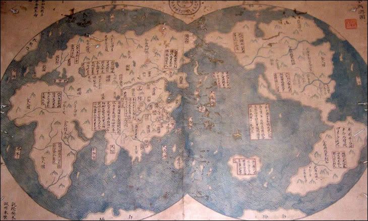
The map clearly shows the Americas and Africa

A map due to be unveiled in Beijing and London next week may lend weight to a theory a Chinese admiral discovered America before Christopher Columbus. The map, which shows North and South America, apparently states that it is a 1763 copy of another map made in 1418.
If true, it could imply Chinese mariners discovered and mapped America decades before Columbus' 1492 arrival.
The map, which is being dated to check it was made in 1763, faces a lot of scepticism from experts.
Chinese characters written beside the map say it was drawn by Mo Yi Tong and copied from a map made in the 16th year of the Emperor Yongle, or 1418.
It clearly shows Africa and Australia.
The British Isles, however, are not marked.
Controversial claim
The map was bought for about $500 from a Shanghai dealer in 2001 by a Chinese lawyer and collector, Liu Gang.
According to the Economist magazine, Mr Liu only became aware of the map's potential significance after he read a book by British author Gavin Menzies.
The book, 1421: The Year China discovered America, made the controversial claim that a Chinese admiral and eunuch, Zheng He, sailed around the world and discovered America on the way.
Zheng He, a Muslim mariner and explorer, is widely thought to have sailed around South East Asia and India, but the claim he visited America is hotly disputed.
The map is now being tested to check the age of its paper and ink, with the results due to be known in February.
Even if it does prove to have been drawn in 1763, sceptics will point out that we still only have the mapmaker's word that he copied if from a 1418 map, rather than from a more recent one.
The discovery is probably true. The journals of Yongle have long been know to have recited the discovery of America.
Of course the support for this version of history comes from: MUSLIMS!
See realted site:
www.admiralzhenghe.org/
One more cultural incursion by Muslims and Chinese.
Egg foo yung in a Burqua!
There's also evidence that Hebrews from a couple of thousand years ago (or more) landed and explored the Americas. The Egyptians, too. If the Chinese finally made it to the Americas in 1421, then it was about damn time.
It's not really difficult to believe that they sailed east and discovered the west coast of the Americas. But it's a lot harder to accept that they not only circumnavigated the globe but went up and down the coast of every contenent, sailed up the major rivers of every continent, pushed their way in wooden boats through the ice-clogged Northwest Passage that defied European ships for centuries, circumnavigated Antarctica and realized there was land beneath the ice, and charted the furthest, most snowbound portions of Russia.
California is out in the Pacific Ocean.
Bye, bye Babs!
Followed the Vikings by 400 years.
No wonder New Orleans flooded. The Mississippi ended before it got to the Gulf.
Looks like California broke away.
Unfortuantely for them, they won't even get Tawain.
Oy vey
Patton and McArthur were right on...
the map is not the territory...
The Egyptians had ships which were more than capable, better, in fact, than those available to Columbus. They also had astronomical knowledge which would have aided in navigation, and some believe they had a form of reverse osmosis to obtain fresh water from the sea. But the Hebrews? What evidence is there that they even had the technology for such a feat?
This map is very suspect. China has a reputation for forging everything from art to missing link fossiles. This is just an attempt to rewrite our history in a dangerous way. It is interesting that the explorer was muslim. Is this an attempt to motivate the US Muslims to fight for the return of their holy land in the Americas? I read somewhere that this version is being taught heavily in the mosques in Mexico. I will try and find a link for it.
Why do people need to hold on to the belief that Columbus was the one and only explorer?
Hmmm. Looks like they sailed into 'Frisco Bay and sailed down into the flooded San Joaquin Valley. Much of the Valley did flood before dams were built, but I don't know if there was enough water to sail a vessel through.
Exactly. My thought also. That amount of sailing and exploring would have been very, very difficult in those days. I think it's fake.
Disclaimer: Opinions posted on Free Republic are those of the individual posters and do not necessarily represent the opinion of Free Republic or its management. All materials posted herein are protected by copyright law and the exemption for fair use of copyrighted works.