| This thread has been locked, it will not receive new replies. |
|
Locked on 09/21/2005 4:38:48 PM PDT by Admin Moderator, reason:
Locked - New Thread http://www.freerepublic.com/focus/f-news/1488924/posts |
Posted on 09/21/2005 1:36:24 AM PDT by NautiNurse
Category 3 Hurricane Rita became the fifth major hurricane of the 2005 season during the night. Hurricane Rita threaded the needle through the Florida Straits and moved into the Gulf of Mexico. Storm damage in the Florida Keys and South Florida Peninsula was light, with scattered power outages, scattered tornados, and mild to moderate flooding.
Mandatory evacuations are in effect for Galveston County TX and New Orleans. Additional evacuation orders in the Greater Houston Metropolitan Area are anticipated throughout the day.
Crude oil prices reacted as oil producers shut down and evacuated workers from platforms in the Gulf of Mexico.
The following links are self-updating:
Public Advisory Currently published every 3 hours 5A, 8A, 11A, 2P, etc. ET
NHC Discussion Published every six hours 6A, 11A, 6P, 11P
Three Day Forecast Track
Five Day Forecast Track
Rita Forecast Track Archive
Forecast Models
Buoy Data Eastern Gulf of Mexico
Buoy Data Western Gulf of Mexico
Current Weather Warnings and Watches for Texas
Images:
Storm Floater IR Loop
GOM WV Loop
GOM IR Still Image
Visible Storm Floater Still (only visible during daylight hours)
Color Enhanced Atlantic Loop
Key West Long Range Radar Still Image
Streaming Video: (coverage may be intermittent)
KHOU-TV/DT Houston: mms://beloint.wm.llnwd.net/beloint_khou
WWLTV NOLA
Additional Resources:
Coastal TX Evacuation Maps
KHOU Houston
KTRK ABC News Houston
Hurricane City
Wxnation Houston
| Category | Wind Speed | Barometric Pressure | Storm Surge | Damage Potential |
|---|---|---|---|---|
| Tropical Depression |
< 39 mph < 34 kts |
Minimal | ||
| Tropical Storm |
39 - 73 mph 34 - 63 kts |
Minimal | ||
| Hurricane 1 (Weak) |
74 - 95 mph 64 - 82 kts |
28.94" or more 980.02 mb or more |
4.0' - 5.0' 1.2 m - 1.5 m |
Minimal damage to vegetation |
| Hurricane 2 (Moderate) |
96 - 110 mph 83 - 95 kts |
28.50" - 28.93" 965.12 mb - 979.68 mb |
6.0' - 8.0' 1.8 m - 2.4 m |
Moderate damage to houses |
| Hurricane 3 (Strong) |
111 - 130 mph 96 - 112 kts |
27.91" - 28.49" 945.14 mb - 964.78 mb |
9.0' - 12.0' 2.7 m - 3.7 m |
Extensive damage to small buildings |
| Hurricane 4 (Very strong) |
131 - 155 mph 113 - 135 kts |
27.17" - 27.90" 920.08 mb - 944.80 mb |
13.0' - 18.0' 3.9 m - 5.5 m |
Extreme structural damage |
| Hurricane 5 (Devastating) |
Greater than 155 mph Greater than 135 kts |
Less than 27.17" Less than 920.08 mb |
Greater than 18.0' Greater than 5.5m |
Catastrophic building failures possible |
Previous Threads:
Hurricane Rita Live Thread, Part I
Tropical Storm Rita
Tropical Depression 18
Good morning check-in. Car 4 already...hmmm.
Anyone under mandatory evac in TX can bring one pet in a small carrier (and one small soft bag, like a duffel bag, for their own personal stuff).
That's what I watch- the mb.
GFS, especially, has Rita basically being stuck in the region from Dallas through NE TX to Arkansas for days and days and days and days....would be a flood of Biblical proportions inland.
I gave her a call. She's a Red Cross volunteer and she is gonna contact me later this morning. It may be safer for her to stay in place rather than get on the road.
Katrina was a Cat 2 at this point in the Gulf. I suspect Rita is gonna make landfall as a Cat 5, or at least a strong Cat 4. The water just gets warmer and warmer from where Rita's at now to the Texas coast, and wind shear is of no consequence. When Katrina got up to New Orleans and the MS coast, it was 'just' a Cat 3..
This is simply mind-numbing. We are completely overcast from Rita. She's a very large storm.
Good idea - especially batteries for a portable radio & top of the gas tank cuz everyone & their dawg will be getting gas & prices are sure to go up, too.
The worse case would be the power going off due to high winds and/or tornadoes. Also, could be some heavy rains so the roads might be closed.
Due to hit the coastline around Saturday at 2 AM. So if it follows the computer models - it could brush near Austin later Saturday maybe early evening.
My Father lives west of Austin.
Good. Sounds like they have their stuff together.
In 1900 they didn't know what was coming, and they did not evacuate.
I heard the mayor of Galveston this morning on FOX- she said pets are welcome BUT they must be in their cages. Lesson learned.
It should downgrade before landfall, the guy on FNC last night said it will hit shallower waters earlier than Katrina did. The shallow waters should start to suck some energy off of Rita, but its still a major 'cane and a few mph here or there really won't matter much.
Your Mom should be fine, just check on her this weekend. Austin is a very good town to be in, unless she lives in a flood zone.
Funny you would say that, I was just counting my ammo and sad to say I'm down to about 1700 rounds ..... then again I don't expect 1699 looters!
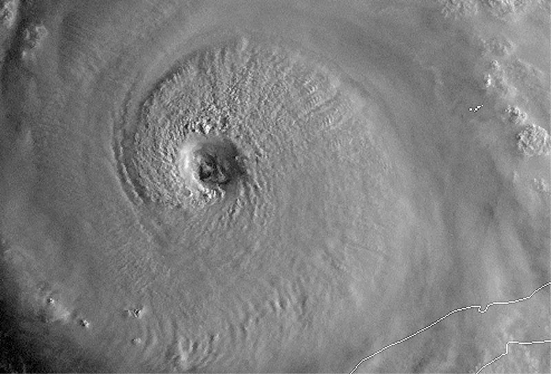
OH MY GOD....that's near a CAT 5...the SAT is AMAZING. one of the strongest i have ever seen....NHC is just guessing, recon plane is broke down , i see the just jump it up to CAT 4 and it looks stornger now then it did an hour ago when they did it
Pinwheel in the eye
http://www.usawx.com/ritaeye830amsept21catfoury.jpg
Texas has been hit by Category 4 hurricanes before. The question is downgrade from what. If it peaks at, say, 190mph a la Camille & Mitch, it could still be Cat 5 despite weakening in the shallows.
I have a sweet pea of sister that lives in Austin. Should things get rough in your mom's area, please contact me via freepmail. I'll be happy to call sis and have her assist your mom in any way possible.
Hidy, folks. Quick in and out, lots going on here.
Still a day or two from finishing the levee assessment for Katrina. Patience, it's a big job.
Found some decent links to help get up to speed on hurricane theory and historical performance in and around the Houston area.
Here's a report on computer flood modeling for Galveston and Gas City, areas of notable concern given the current course tracks and eyewall radius:
http://yosemite.epa.gov/oar/globalwarming.nsf/UniqueKeyLookup/SHSU5BPHYX/$File/chapter5.pdf
The first half is in reference to global warming, just scroll down to the hurricane surge section for the useful info.
Here's an overview of past hurricanes and how they affected various areas:
http://www.h-gac.com/NR/rdonlyres/evyjm5vyexn3f6v3jdam2mdkmxrjk4gzunftekkv5r2p7gyqlo3ssai5e674anordggfhhm3kgk6jtai6j3d6pgkhtf/Section+4.2+Hazard+Analysis.pdf
If someone could note a couple of the more significant storms and post some links to more detailed data on what effects they had, especially surge and runoff flooding, I'd appreciate it. I know others are busy too, so if there aren't any pings back on this by tonight, I'll dig some up myself. I'm good on the Galveston storm, but it's a good example for this one as long as the track stays steady.
Still too early to call a landfall location, but as the storm gets closer to shore, I'll pull down some 10 meter per pixel elevation models and do some surge forecasting, but don't expect to see that until Thursday or Friday.
A from a quick and dirty 30 meterper pixel surge simulation I ran, a very rough rule of thumb is that the 20 foot line tends to be around 10 miles inland from CC to Houston. Do NOT use this figure for any more than a rough idea of what to expect, local conditions and terrain and actual landfall location will be the final determinant.
That's all for now, I'll be lurking until about 24 hours before landfall, popping in only occasionally till then.
For you hardcore, and you know who you are, plan your weekend for some long stints online, and be ready to settle in for the long haul too. Houston isn't New Orleans, but this storm has the potential to rival the mighty Katrina herself, in windspeed and surge. For some odd reason, possibly random chance, historically, Texas hurricanes seem to stall frequently just onshore, so be looking at total rainfall potentials too.
Hasta for now...
JMHO
hurricane prep
NOLA: don't worry be happy
TX: Git R Done!
Disclaimer: Opinions posted on Free Republic are those of the individual posters and do not necessarily represent the opinion of Free Republic or its management. All materials posted herein are protected by copyright law and the exemption for fair use of copyrighted works.