Posted on 09/10/2005 2:31:49 PM PDT by NautiNurse
Hurricane Ophelia continues to churn off the off the coast of the Carolinas with a track that has confounded computer models and meteorologists for days. Hurricane watches are issued for much of the SC and NC coastline. Northern GA and southern VA coastal areas are currently within the three day cone of uncertainty. Check local NWS service for updates.
The following links are self-updating:
Public Advisory Currently published every 3 hours 5A, 8A, 11A, 2P, etc. ET
NHC Discussion Published every six hours 6A, 11A, 6P, 11P
Three Day Forecast Track
Five Day Forecast Track
Navy Storm Track Graphics, Satellite
Ophelia Track Forecast Archive
Forecast Models
Buoy Data SE U.S.
Myrtle Beach NWS Local Hurricane Statements
Wilmington NC NWS Local Hurricane Statements
Images:
Storm Floater IR Loop
Storm Floater WV Still Image
Morehead City Long Range Radar Loop
Wilmington NC Long Range Radar Loop
Charleston SC Long Range Radar Loop
Wakefield VA Radar
Morehead City Experimental Radar may experience delays or outages
Storm Floater Still & Loop Options
Color Enhanced IR Loop
Ophelia Wind Field Graphic
Additional Resources:
Myrtle Beach Online
WECT-6 Wilmington News
WVEC-13 Hampton Roads/Norfolk
Hurricane City
Myrtle Beach Web Reports Surf & traffic cams
| Category | Wind Speed | Barometric Pressure | Storm Surge | Damage Potential |
|---|---|---|---|---|
| Tropical Depression |
< 39 mph < 34 kts |
Minimal | ||
| Tropical Storm |
39 - 73 mph 34 - 63 kts |
Minimal | ||
| Hurricane 1 (Weak) |
74 - 95 mph 64 - 82 kts |
28.94" or more 980.02 mb or more |
4.0' - 5.0' 1.2 m - 1.5 m |
Minimal damage to vegetation |
| Hurricane 2 (Moderate) |
96 - 110 mph 83 - 95 kts |
28.50" - 28.93" 965.12 mb - 979.68 mb |
6.0' - 8.0' 1.8 m - 2.4 m |
Moderate damage to houses |
| Hurricane 3 (Strong) |
111 - 130 mph 96 - 112 kts |
27.91" - 28.49" 945.14 mb - 964.78 mb |
9.0' - 12.0' 2.7 m - 3.7 m |
Extensive damage to small buildings |
| Hurricane 4 (Very strong) |
131 - 155 mph 113 - 135 kts |
27.17" - 27.90" 920.08 mb - 944.80 mb |
13.0' - 18.0' 3.9 m - 5.5 m |
Extreme structural damage |
| Hurricane 5 (Devastating) |
Greater than 155 mph Greater than 135 kts |
Less than 27.17" Less than 920.08 mb |
Greater than 18.0' Greater than 5.5m |
Catastrophic building failures possible |
I was thinking it looks like they will get the honors of landfall.
The short answer it can't happen in our Milena except for an event that would raise sea levels 2-3'.
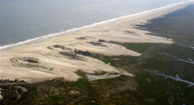
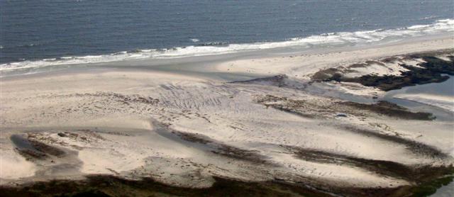
The banks are the remnants of ice age beach shores when sea levels were much lower. The sounds behind them were dry, low plains. Rising sea levels flooded the plains turning them into sounds and the high dune areas of the beaches became the barrier islands.
The Islands are in a constant state of movement, always migrating to the west. In a few Milena or eons there will be no banks or inland sounds in North Carolina. Hurricanes just speed up this process by over-washing the islands and pushing huge quantities of sand to the west. eventually this sand will sprout marsh grass and maybe even some maritime forest which will stabilize the area until the next weather catastrophe nibbles at it again.
This picture is from an over-wash at Drum Inlet, about 22 miles north of Cape Lookout. I camped toward the ocean in this picture in August of 2003 about 2 months before the eye of Hurricane Isabel crossed this exact location. Before the storm there was a huge whalebone pelvis at the ocean side of the edge of the dunes. I went back a year later and found the whale bone in the marsh on the edge of the sound. A Category 2 storm only moved it 300-400 yards.
There is some very good coverage here:
www.witntv.com
A friend's mother was at Atlantic Beach in a condo with her dog and was going to ride out the storm. However, her daughter thought better of that and she has been retrieved from the coast up here to Raleigh. I am very glad to hear that seeing that it looks like the landfall will be right there at Atlantic Beach.
Bump for later.
"My 62 year old mother spent 12 hours in a tree when Floyd hit."
Where was she, what town? Boy, I can only imagine my mother after 12 hours in a tree, and I sure don't even like to entertain the thought! lol
We had a royal mess with Floyd.
Thanks for the geology/geography lesson. I guess there is no need to worry in our life times. It seems such a beautiful area, no wonder people love to live there.
I understand all of Hyde County is under mandatory evacuation.
My weatherman in G'ville just said, about 12 times, he's been watching storms for 27 years and has NEVER seen a CAT 1 like this.
It mentions concern for Ft. Macon State Park due to extensive
flooding potential more than winds with Ophelia. More Ft. Macon
history info here.
Oh he!!, I hope it wasn't MY son!
Your son went to check the wind?
Mind did too. Power out in the barracks.
Heard they quit selling beer yesterday at 3 pm. : )
FReepmail me and tell me where your son is, and I'll tell you where mine is! LOL
I'll see your bump - how are you doing?
Greenville had such bad flooding in Hurricane Floyd - and ECU cancelled classes for today and tomorrow - what is the rainfall like in Greenville?
I'm fine, thanks!
Gramps has a trip scheduled for S. Car. on Friday morning. When I find out the exact location...I'm gonna come back here and plead for news.
Stay tuned for unabashed pleading...HA!
Glad to hear your friend got her mother to a safe location. The damage reports are going to be ugly due the the persistent pounding.
You know if they hadn't stopped selling beer, everyone would have stayed safe inside of the barracks. Passed out but safe. LOL,
That'll be the thing to do - but I can't help you with SC news. At least it seems they are out of trouble now.
Yes the extensive pounding of the rain and surf will take its toll even if the winds have not been that high.
Right now, it's dry as a bone, which I can't figure out! Earlier (3 hours ago, maybe?) it was raining almost horizontally. They're only calling for 50mph winds here, tonight, so no biggy. Dumb girl here...came up from SC this week for work. I've been referring to myself as a storm-chaser all week!
Hurricane Ophelia Intermediate Advisory Number 35b
Statement as of 9:00 PM EDT on September 14, 2005
...Sustained hurricane force winds reach Cape Lookout...


a Hurricane Warning remains in effect for all of the North Carolina
coast from Little River Inlet northward to the North
Carolina/Virginia border...including the Pamlico and Albemarle
sounds.


A Hurricane Watch and a Tropical Storm Warning remain in effect
north of the North Carolina/Virginia border to Cape Charles
Light Virginia...including the Chesapeake Bay south of New Point
Comfort.


A Hurricane Warning means that hurricane conditions are expected in
the warning area within the next 24 hours.  A Hurricane Watch means
that hurricane conditions are possible in the watch area within the
next 36 hr.  A Tropical Storm Warning means that tropical storm
conditions are expected in the warning area within the next 24
hours.


For storm information specific to your area...including possible
inland watches and warnings...please monitor products issued
by your local weather office.


At 9 PM EDT...0100z...the center of Hurricane Ophelia was located
near latitude 34.2 north... longitude 76.8 west or about 35 miles
south-southwest of Cape Lookout North Carolina.


Ophelia is moving erratically toward the east-northeast near 7
mph...and this general motion is expected to continue for the next
24 hours. The center of Ophelia is expected to pass over or very
near Cape Lookout within the next several hours...and the northern
eyewall will continue to pass over coastal North Carolina and the
outer bands tonight and during much of tomorrow.


Maximum sustained winds...likely located offshore in the eastern
portion of the eyewall...are near 85 mph...with higher gusts.
Ophelia is a category one hurricane on the Saffir-Simpson scale.
Some slight strengthening is possible overnight. Cape Lookout
recently reported a 10-minute mean wind of 75 mph...with a gust to
92 mph.


Hurricane force winds extend outward up to  50 miles from the
center...and tropical storm force winds extend outward up to 140
miles.


The latest minimum central pressure measured by reconnaissance
aircraft was 979 mb...28.91 inches.


Maximum coastal storm surge flooding of 5 to 7 feet above normal
tide levels...along with large and dangerous battering waves...can
be expected in areas of onshore flow.  A storm surge of 9 to 11
feet is possible at the heads of bays and rivers.


Ophelia is expected to produce additional rainfall accumulations of
4 to 8 inches over portions of eastern North Carolina during the
next 24 hours...with maximum storm total amounts of 15 inches
possible.


Isolated tornadoes are possible over northeastern North Carolina
tonight.


Repeating the 9 PM EDT position...34.2 N... 76.8 W.  Movement
toward...east-northeast near  7 mph.  Maximum sustained
winds... 85 mph.  Minimum central pressure... 979 mb.


The next advisory will be issued by the National
Hurricane Center at 11 PM EDT.


Forecaster Franklin
Disclaimer: Opinions posted on Free Republic are those of the individual posters and do not necessarily represent the opinion of Free Republic or its management. All materials posted herein are protected by copyright law and the exemption for fair use of copyrighted works.