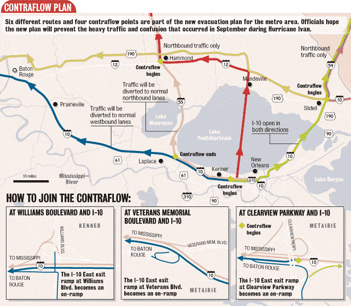
For FReepers who are following the traffic cams. Contraflow didn't go so well during Ivan, lets hope its better this time.
| This thread has been locked, it will not receive new replies. |
|
Locked on 08/27/2005 8:52:34 PM PDT by Admin Moderator, reason:
Locked - New Thread http://www.freerepublic.com/focus/f-news/1472123/posts |
Posted on 08/26/2005 10:25:04 PM PDT by NautiNurse
Hurricane Katrina continues to strengthen in the Gulf of Mexico. Currently, the forecast models are converging upon New Orleans. However, all interests in the northern Gulf of Mexico should follow the path of this storm, and be prepared for a major hurricane landfall. Throughout Friday, the official track forecasts moved west, as Hurricane Katrina delayed making the anticipated northwest turn.
The following links are self-updating.
Public Advisory Currently published every 3 hours 5A, 8A, 11A, 2P, etc. ET
NHC Discussion Published every six hours 6A, 11A, 6P, 11P
Three Day Forecast Track
Five Day Forecast Track
Navy Storm Track
Katrina Track Forecast Archive Nice loop of each NHC forecast track for both three and five day
Forecast Models
Alternate Hurricane Models via Skeetobite
Buoy Data Florida
Bouy Data Louisiana/Mississippi
Images:
New Orleans/Baton Rouge Experimental Radar Subject to delays and outages - and well worth the wait
Ft. Polk, LA Long Range Radar Loop
Northwest Florida Long Range Radar
Storm Floater IR Loop
Storm Floater Still & Loop Options
Color Enhanced IR Loop
Other Resources:
Hurricane Wind Risk Very informative tables showing inland wind potential by hurricane strength and forward motion
Central Florida Hurricane Center
Hurricane City
Crown Weather Tropical Website Offers a variety of storm info, with some nice track graphics
Live streaming:
WFOR-TV Miami: http://dayport.wm.llnwd.net/dayport_0025_live
WWL-TV New Orleans: mms://beloint.wm.llnwd.net/beloint_wwltv
HurricaneCity.com: http://hurricanecity.com/live.ram
WTSP-TV Tampa: mms://wmbcast.gannett.speedera.net/wmbcast.gannett/wmbcast_gannett_jan032005_0856_78183
WKRG-TV Mobile mms://wmbcast.mgeneral.speedera.net/wmbcast.mgeneral/wmbcast_mgeneral_jul072005_1144_93320
Katrina Live Thread, Part II
Hurricane Katrina Live Thread, Part I
Tropical Storm 12
| Category | Wind Speed | Barometric Pressure | Storm Surge | Damage Potential |
|---|---|---|---|---|
| Tropical Depression |
< 39 mph < 34 kts |
Minimal | ||
| Tropical Storm |
39 - 73 mph 34 - 63 kts |
Minimal | ||
| Hurricane 1 (Weak) |
74 - 95 mph 64 - 82 kts |
28.94" or more 980.02 mb or more |
4.0' - 5.0' 1.2 m - 1.5 m |
Minimal damage to vegetation |
| Hurricane 2 (Moderate) |
96 - 110 mph 83 - 95 kts |
28.50" - 28.93" 965.12 mb - 979.68 mb |
6.0' - 8.0' 1.8 m - 2.4 m |
Moderate damage to houses |
| Hurricane 3 (Strong) |
111 - 130 mph 96 - 112 kts |
27.91" - 28.49" 945.14 mb - 964.78 mb |
9.0' - 12.0' 2.7 m - 3.7 m |
Extensive damage to small buildings |
| Hurricane 4 (Very strong) |
131 - 155 mph 113 - 135 kts |
27.17" - 27.90" 920.08 mb - 944.80 mb |
13.0' - 18.0' 3.9 m - 5.5 m |
Extreme structural damage |
| Hurricane 5 (Devastating) |
Greater than 155 mph Greater than 135 kts |
Less than 27.17" Less than 920.08 mb |
Greater than 18.0' Greater than 5.5m |
Catastrophic building failures possible |
Same here.
Yeah...and also Biloxi and Gulfport...said he has to get them ALL cleared. He said it is getting wild...the FEMA and other emerg agencies starting to set up.
LOL. Madame Hamhocks

Good luck and God be with him, with that massive task.
I agree. Who votes for morons like her???
holy moly....check out the Sat now its really exploding..and it looks like its turning NW now..and maybe increasing in speed..hard to tellwith all the blow up
One time we took the kids downtown to go the Aquarium and IMAX. As we got ready to leave, it started to pour down rain. By the time we got to our car and were driving past where we had been just standing, they had already sandbagged all the doors to the shops and the water was already well over ankle deep. And that was just a brief summer thunderstorm!
I doubt they volunteered to go in most cases.
You do what your news director tells you to do.
But, if I were them, I would say no in this case, even if it cost me my job.
Journalism is an exciting career, but I would not risk my life over a hurricane. Perhaps covering a war. Not a hurricane.
Time for some cliches....
It's Bush's fault...
It's because of Global Warming
"Women and minorities hit hardest"
Clearing VA Hospitals in NO, BR, Biloxi and Gulfport sounds downright incredible to accomplish in 24 hours.
It should begin to make the turn shortly. It is very hard to tell exactly where it is going though at this point.
what on earth possessed you to post something so asinine here?
ah, thanks for correcting me
Ha! Each of her LEGS weigh 130 lbs!;)
That's real ugly.
August tourism in NOLA is probably the lowest point of the year. It's nasty hot and muggy.
People don't have to afford hotel rooms....schools always open gyms, etc for evacuees. Last time they evacuated Savannah IIRC they took the poor and/or elderly people to Macon on school buses (I remember some of them were grousing because the buses weren't air conditioned.)
to demonstrate absurdity by being upsurd. You know that the rats will blame Bush and global warming. And someone in the media will say "women and minorities hit hardest."
wow!
That is positively frightening.
For still being in an eyewall replacement cycle according to the NHC, it sure hasn't lost much punch at all......and may be strengthening with the latest pressure being DOWN again despite the cycle.
Just incredible...and scary. It certainly is getting big.
Disclaimer: Opinions posted on Free Republic are those of the individual posters and do not necessarily represent the opinion of Free Republic or its management. All materials posted herein are protected by copyright law and the exemption for fair use of copyrighted works.