Skip to comments.
Hurricane Isabel:Live Thread #2 "Force Ten Conditions In North Carolina And Further North"
NHC
| 9-17-03
| My Favorite Headache
Posted on 09/17/2003 8:14:30 PM PDT by My Favorite Headache
Hurricane Isabel Advisory Number 48
Statement as of 11:00 PM EDT on September 17, 2003
...Outer bands of Hurricane Isabel moving onshore...weather should gradually worsen...
A Hurricane Warning remains in effect from Cape Fear North Carolina to Chincoteague Virginia...including Pamlico and Albemarle sounds...and the Chesapeake Bay south of Smith Point. A Hurricane Warning means that hurricane conditions are expected within the warning area...generally within 24 hours.
All preparations to protect life and property should be rushed to completion in the Hurricane Warning area.
A Tropical Storm Warning remains in effect south of Cape Fear to South Santee River South Carolina...and north of Chincoteague to Sandy Hook New Jersey...including Delaware Bay. A Tropical Storm Warning also remains in effect for the Chesapeake Bay from Smith Point northward...and for the tidal Potomac.
At 11 PM EDT...0300z...the center of Hurricane Isabel was located by an Air Force reconnaissance aircraft near latitude 31.9 north... longitude 73.9 west or about 250 miles south-southeast of Cape Hatteras North Carolina.
Isabel is moving toward the north-northwest near 13 mph. A turn to the northwest with an increase in forward speed is expected prior to landfall. On the forecast track...the center of Isabel is expected to make landfall in eastern North Carolina during the day Thursday. However...conditions will deteriorate over a large area well before the center reaches the coast. Tropical storm conditions are already spreading across the coastline.
Maximum sustained winds are near 105 mph...with higher gusts. A slight increase in strength is possible prior to landfall.
Hurricane force winds extend outward up to 115 miles from the center...and tropical storm force winds extend outward up to 315 miles. A buoy located west of the hurricane recently reported wind gusts to 74 mph and 32 foot waves.
An Air Force hurricane hunter plane recently reported a minimum central pressure of 956 mb...28.23 inches.
Storm surge flooding of 7 to 11 feet above normal tide levels... along with extremely large and dangerous battering waves...is expected near and to the north of where the center crosses the coast. Storm surge flooding of 4 to 8 ft above normal tide levels is expected in Chesapeake Bay and the tidal portions of adjacent rivers.
Storm total rainfalls of 6 to 10 inches...with locally higher amounts...are likely in association with Isabel.
There is a threat of isolated tornadoes over eastern North Carolina and southeastern Virginia on Thursday.
Repeating the 11 PM EDT position...31.9 N... 73.9 W. Movement toward...north-northwest near 13 mph. Maximum sustained winds...105 mph. Minimum central pressure... 956 mb.
For storm information specific to your area...please monitor products issued by your local weather office.
An intermediate advisory will be issued by the National Hurricane Center at 2 am EDT followed by the next complete advisory at 5 am EDT.
Forecaster Avila
TOPICS: Breaking News; News/Current Events; US: North Carolina; US: Virginia
KEYWORDS: hurricane; hurricaneisabel; isabel; landfall
Navigation: use the links below to view more comments.
first previous 1-20 ... 1,161-1,180, 1,181-1,200, 1,201-1,220 ... 2,161-2,170 next last
To: MoJo2001
I doubt New Bern has power. I believe that I heard yesterday that the peak of the storm surge was supposed to be on the Neuse River at New Bern. And even in good weather the cell coverage there is abysmal.
1,181
posted on
09/18/2003 12:01:20 PM PDT
by
NCjim
To: Lazamataz
Huh? What's that you say?
To: Mo1
note to self... if you go out in a hurricane to walk around on national tv... wear a belt. duh.
1,183
posted on
09/18/2003 12:01:55 PM PDT
by
glock rocks
(prayers for family and friends in Isabel's path)
To: wimpycat
I was laughing SO hard at Jeff goldlatt on fox. I felt bad for it too but he was being so funny. He was standing in an alley or something because he said "let's get out of this windtunnel" at the end and was fine after that. He appears to be having fun with the situation.
To: Mo1
I know Hurricanes are nothing to laugh at .. But Jeff is kind of funny running around like he isAs I alluded to earlier, TWC's Jim Cantore has nothing on Fox's Jeff Goldblat.
1,185
posted on
09/18/2003 12:02:21 PM PDT
by
meyer
To: Lazamataz
Oh, geez, Laz. Only you!
To: mhking
I don't think Laz lived here then. So, I guess he is allowed to make up his own history of Georgia's weather.
1,187
posted on
09/18/2003 12:02:31 PM PDT
by
CFW
To: mhking
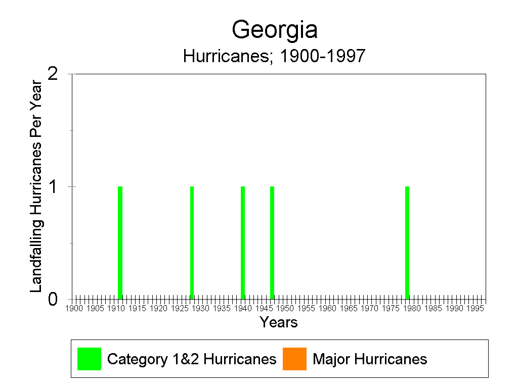
Didn't Hurricane Bob make it to Georgia back in 1979? I was in New Orleans at the time and I remember it missed us to the east... definately hit Mississippi, perhaps Georgia too?
To: Lazamataz; U S Army EOD
"I'm in Georgia. Georgia has never experienced a hurricane, ever." 1995 or 1996, Hurricane Opal, still cat 1 when the eye passed just east of Villa Rica, where I was living in then. Jim Cantore pulled an all nighter on WGST am 640 that night.
A wind gage at a local dirt strip airport recorded a 125 mph gust before it broke.
1,189
posted on
09/18/2003 12:03:09 PM PDT
by
Vigilantcitizen
(Game on in ten seconds...http://www.fatcityonline.com/Video/fatcityvsdemented.WMV)
To: wimpycat
Oh okay! Thank you!! Still trying to get to him on his cellphone.
1,190
posted on
09/18/2003 12:03:20 PM PDT
by
MoJo2001
(God Bless Our Troops and Allies!!)
To: 1Old Pro
RUSH just said Hillary will call a press conference to blame the hurricane on BUSH. Not the hurricane, the plywood shortage. Some plywood is going to Iraq.
1,191
posted on
09/18/2003 12:03:23 PM PDT
by
RightWhale
(Repeal the Law of the Excluded Middle)
To: honeygrl
Oh my! That's where my daughter was conceived :(
To: southernnorthcarolina
Wind blowing toward the outfield at 58 mph. Orioles leading 29-26 in the top of the 3rd. LOL. I can imagine it now...Williams hits a towering drive to center...to short...the catcher's chasing it behind the plate...and it ends up in the stands. Foul ball.
To: VRWC_minion
Maybe their wind speed indicators went out. The year that Bertha and Fran hit Emerald Isle, they had the mayor on the phone during Fran. He said that they had no idea how high the winds were since they were taken out by Bertha.
1,194
posted on
09/18/2003 12:04:32 PM PDT
by
NCjim
To: glock rocks
note to self... if you go out in a hurricane to walk around on national tv... wear a belt. duh. That would be a good idea;0)
1,195
posted on
09/18/2003 12:04:32 PM PDT
by
Mo1
(http://www.favewavs.com/wavs/cartoons/spdemocrats.wav)
To: NCjim
Oh okay! Thanks for letting me know. We are all so worried about him. His mom is really sick and he went home to be with her. We talked to him Tuesday and they were okay. We are hoping and praying that they remain that way.
1,196
posted on
09/18/2003 12:04:46 PM PDT
by
MoJo2001
(God Bless Our Troops and Allies!!)
To: RightWhale
Some plywood is going to Iraq.The storm's bigger than I thought. :)
1,197
posted on
09/18/2003 12:04:46 PM PDT
by
meyer
To: MoJo2001
Issued at: 2:58 PM EDT 9/18/03 (gateway).
Isabel moving inland, made landfall at 1 pm near drum inlet,
A hurricane warning remains in effect from cape fear north carolina to chincoteague virginia, including pamlico and albemarle sounds, and the chesapeake bay south of smith point.
A tropical storm warning remains in effect north of chincoteague to moriches inlet new york, including delaware bay. A tropical storm warning remains in effect south of cape fear to south santee river south carolina, for the chesapeake bay from smith point northward, and for the tidal potomac.
At 3 pm edt, 1900z, the center of hurricane isabel was located near latitude 35.4 north, longitude 76.6 west or about 50 miles east-southeast of greenville north carolina. Isabel made landfall at 1 pm edt near drum inlet, between cape lookout and ocracoke island north carolina.
Isabel has a very large eye, and winds within the eye will diminish, before increasing rapidly as the back edge of the eye passes by. People are strongly cautioned not to venture out during the eye passage unless absolutely necessary.
Isabel is moving toward the northwest near 20 mph and this motion is expected to continue today with a turn to the north-northwest overnight. On the forecast track, the center of isabel is expected to continue moving inland over eastern north carolina and southeastern virginia over the next 24 hours.
Maximum sustained winds are near 95 mph with higher gusts. Although isabel will weaken as it moves inland, unusually strong winds, with gusts to hurricane force, may be experienced far inland over the elevated terrain of northern virginia and maryland, as well as on high-rise buildings and other structures.
Hurricane force winds extend outward up to 115 miles from the center, and tropical storm force winds extend outward up to 345 miles.
Duck pier north carolina just reported a gust to 92 mph. Wallops island maryland recently reported a wind gust to 61 mph.
The estimated minimum central pressure is 959 mb, 28.32 inches.
Storm surge flooding of 5 to 8 feet above normal tide levels, along with extremely large and dangerous battering waves, is expected near and to the north and east of the center. Storm surge flooding of 4 to 8 ft above normal tide levels is expected in chesapeake bay and the tidal portions of adjacent rivers.
Storm total rainfalls of 6 to 10 inches, with locally higher amounts, are likely in association with isabel.
There is a threat of isolated tornadoes over eastern north carolina, eastern virginia, and southeastern maryland today.
Repeating the 3 pm edt position, 35.4 n, 76.6 w. Movement toward, northwest near 20 mph. Maximum sustained winds, 95 mph. Minimum central pressure, 959 mb.
For storm information specific to your area, please monitor products issued by your local weather office, and statements from local emergency management officials.
The next advisory will be issued by the national hurricane center at 5 pm edt.
To: mhking
Still just moderate rain and not much wind here in Alexandria, VA. Not that I'm complaining!
To: Lazamataz
REPENT!
1,200
posted on
09/18/2003 12:05:08 PM PDT
by
MEG33
Navigation: use the links below to view more comments.
first previous 1-20 ... 1,161-1,180, 1,181-1,200, 1,201-1,220 ... 2,161-2,170 next last
Disclaimer:
Opinions posted on Free Republic are those of the individual
posters and do not necessarily represent the opinion of Free Republic or its
management. All materials posted herein are protected by copyright law and the
exemption for fair use of copyrighted works.
FreeRepublic.com is powered by software copyright 2000-2008 John Robinson