Posted on 12/01/2001 8:17:03 AM PST by Dog Gone
Looks like it's going to happen afterall. RIP Big Easy.
Wow! How prescient was that thread?
And at least one more after that...
Askel5, you okay?
She was banned...
DU?
Sign up just to bump this?
Scarily prescient!
You are correct. Evidenced by the great flood of '93 along the Missouri and Mississippi.Two things are at fault. Our attempt to make the major rivers navigable year round, and the desire to live "near the water".
As a result of these, we build levees and wait for them to break with disasters as a result. In the '93 flood the Corp of Engineers was ready to breach the levee south of St Louis to rescue St Louis (if necessary) and to keep Cairo Il and other towns from complete devastation. To do so would have flooded thousands of acres of farmland and residential property.
Your threads back ....................
Yup. All the way until 2005, when Mardi Gras stopped.
Good work finding this thread.
Really? We hold Mardi Gras here in Lafayette, LA every year, and nobody here's mentioned a thing about this year's being the last. In fact, I'll bet you 2006's will be one of our largest ever....
...laissez les bon temps roulet...#8-)
A similar plan exists or existed as shown on this map. The Spillway at Laplace(lets river go down by draining it into Lake Pont. cannot be used until the lake leaking into the city is fixed). Here's what I've heard(from civil engineers with a clue):
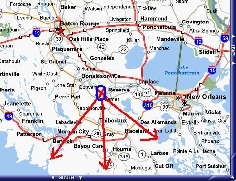
May or may not be used. CE's say river levee is OK for now BUT the designer(read engineer) and/or contractor involved in the lake section that gave way are now living their worst nightmare and should be "tarred & feathered". IF the engineer(s) are "PE"'s, they should have their license(s) revoked ASAP if it's the design fault. Shoulda' been at least a 4X load safety factor somewhere in there...
By the way, I have good friends in Metarie. Anybody hear any news about whats going on there?
I do know civil engineers in south La and NOLA. The ones I've been able to get in touch with say the river levee is good for now. When I asked about what is on the posted map I got silence followed by "the river levee's good" followed by a passion-filled rant about "the fools involved in the one by the lake that broke should be hung out to dry. That should've never happened". I can understand that as I'm in petrochem. If I make a mistake and it goes unchecked things could blow up and people get killed.
The map shown was discussed with some in the late 1980's for use in a "Worst Case Scenario"(i.e. river about to detour via NOLA). I'd consider it to be Plan 9,999 as using it now would only add to a disaster...not prevent one.
A close relative(civil engineer, PE) packed and left Metarie Thursday. Same relative is now looking for an apartment in Houston plus enrolling 2 children in Houston's schools. Home was located between West Metairie Road and Veterans Memorial Highway(-5 feet below sea level).
A LOT of Metairie not on the natural ridge made by the river in the past will be under water.
Here's a link to a useful graphic(too large to put here):
http://www.nola.com/hurricane/images/goingunder_jpg.jpg
What happens after that(i.e. the total depravity of man being exhibited) will be determined by the force used to CONTROL desparate, and in some cases sick/criminal, people. Sheriff Harry Lee would've handled it. I don't know the current one.
bump
Disclaimer: Opinions posted on Free Republic are those of the individual posters and do not necessarily represent the opinion of Free Republic or its management. All materials posted herein are protected by copyright law and the exemption for fair use of copyrighted works.