Posted on 10/09/2024 6:09:13 PM PDT by TBP
Florida residents must feel like they have been taking a beating from major hurricanes in recent years, but what do the data show?
The problem with human perception of such things is that the time scale of hurricane activity fluctuations is often longer than human experience. For example, a person born in the 1950s would have no memory of the beating Florida took in the 1940s from major hurricanes (a total of 5). But they would have many memories of the hurricane lull period of the 1970s and 1980s, each decade having only one major hurricane strike in Florida. Then, when an upswing in hurricane strikes occurs, it seems very unusual to them, and they assume that “hurricanes are getting worse”.
Another problem is that any statistics for an area as small as Florida, even over 100+ years, will be pretty noisy. Landfalling hurricanes for the eastern U.S. would be a better metric. And statistics for the entire Atlantic basin would be even better, except that satellite coverage didn’t start until the 1970s and hurricane intensity in remote areas before then would be poorly measured (or not measured at all).
Finally, tropical cyclone statistics for the entire tropics would be the best (if one was trying to determine if climate change is impacting cyclone intensity or frequency). But satellite data for the global tropics is, again, limited to the period since the 1970s. Global tropical cyclone data before the 1970s is sketchy, at best.
So, keeping in mind that any trends we see for Florida are going to be strongly influenced by the “luck of the draw” and the quasi-random nature of hurricane tracks (hurricanes are steered by the large-scale flow of air in the mid-troposphere, say around 20,000 ft altitude or so), what are the statistics of Florida major hurricane intensity and frequency since 1900?
Florida Major Hurricane Intensity & Number
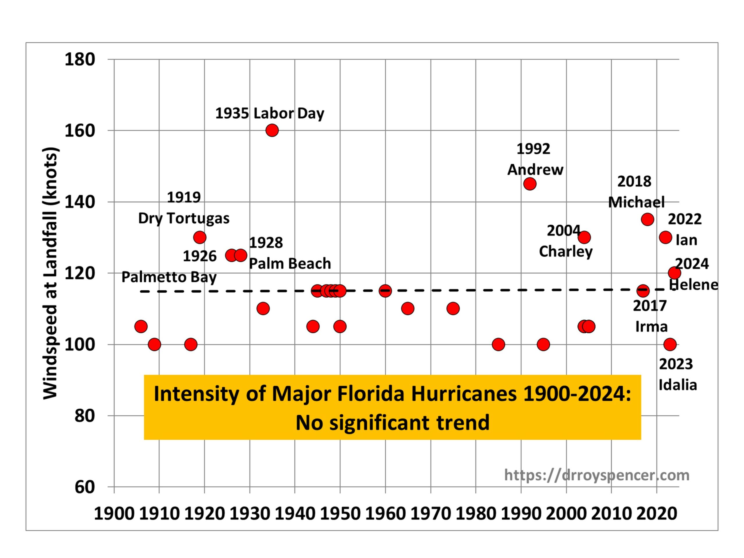
The following plot shows the intensity of major hurricanes (100 knots or greater maximum sustained wind speed) striking Florida since 1900, updated through recent (2024) Hurricane Helene:

As can be seen from the linear trend line, there has been no significant trend in the intensity of major hurricanes striking Florida since 1900.
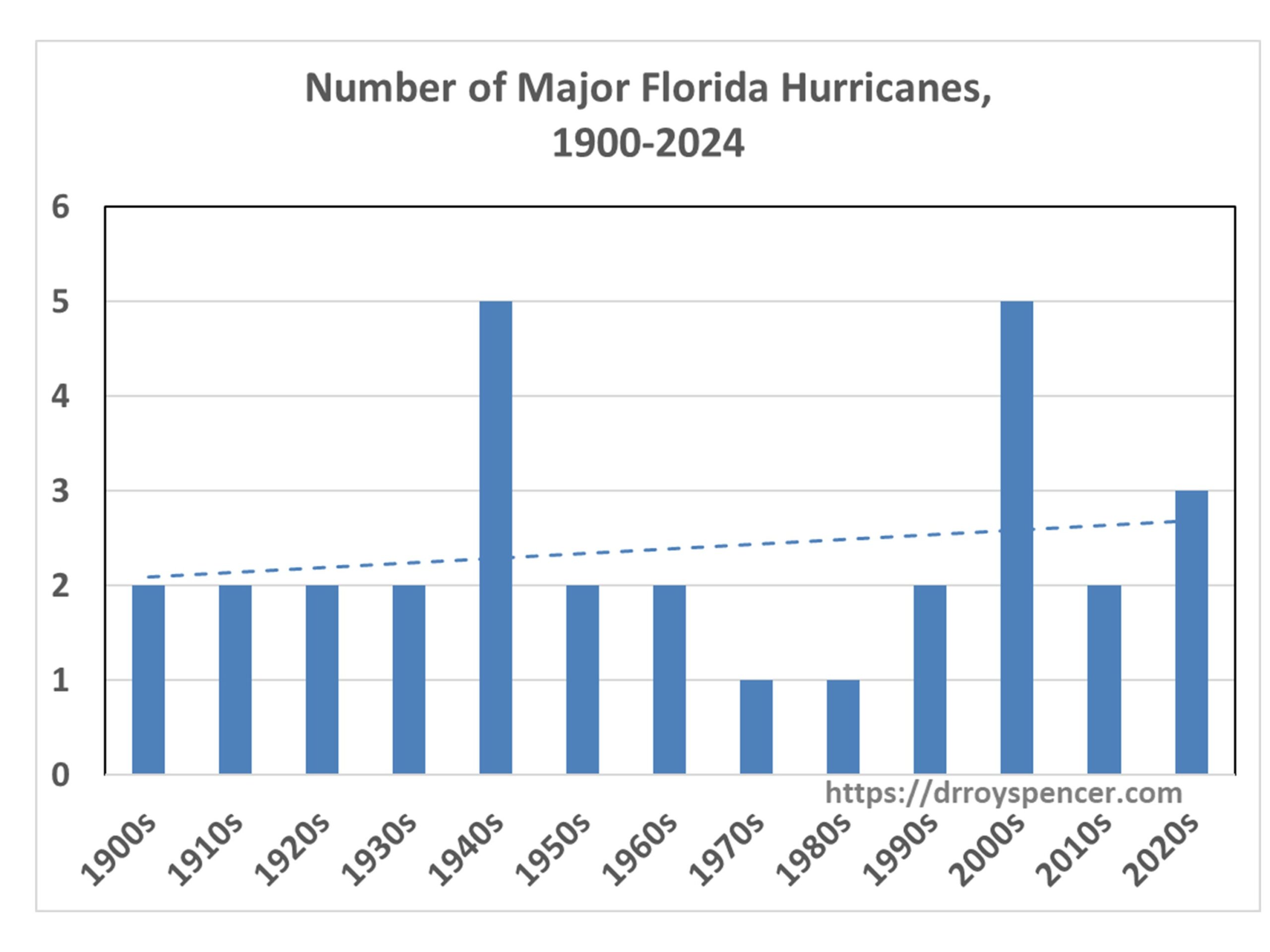
But what about the number of hurricanes? The next plot shows there has been a weak upward trend in the decadal totals of major hurricanes striking Florida since 1900:

Note that the 2020s number might well increase, since the end of the current (2024) hurricane season will be only half-way through the 2020s. While Hurricane Milton has just been classified as a major hurricane, in 2 days time it is expected to be under increasing wind shear, so it is not obvious it will strike Florida as a major hurricane, and so I did not include it in the above charts.
Another feature of the second chart above shows that a native Floridian born in the 1960s or 1970s would indeed have experienced an increase in major hurricanes striking Florida during their lifetime. But their first couple of decades of personal experience would have occurred during a historic lull in hurricane activity.
Why Start In 1900?
There is reason to believe that the number and/or intensity of major hurricanes striking Florida in the early 1900s has been underestimated, which would bias the trends in the above plots in the upward direction, spuriously suggesting a long-term increase in activity. First of all, there were virtually no people living in Florida in 1900. The population of Miami in 1896 was 444 persons. The intensity of a hurricane is based upon its maximum sustained 1 minute windspeed, which usually covers a very small area. Even with people now inhabiting much of the Florida coastline, it is rare for a coastal anemometer to measure the intensity that the National Hurricane Center gives to a hurricane, because those winds cover such a small area. So, how could it ever be known how intense some hurricanes were in the early 1900s?
Evidence for Long-Term Hurricane Fluctuations Unrelated to Water Temperature<.b>
Modern concern centers on the possibility that warm sea surface temperatures from global warming caused by anthropogenic CO2 emissions is making hurricanes stronger or more frequent. But studies of coastal lagoon sediments along the Gulf coast and Caribbean deposited by catastrophic hurricane landfalls show large fluctuations in activity on centennial to millennial time scales, even in the absence of the unusually warm sea surface temperatures measured today. (Example here.)
It should also be remembered that not long ago the U.S. experienced an “unprecedented” 11-year drought in major hurricane strikes. That significantly impacts our perception of what is “normal”. When the lull had reached 9 years, a NASA study found such an event was a 1-in-177-years occurrence. As I recall, that was increased to 1-in-250 years when the lull reached 11 years.
The point is that there is a huge amount of natural decadal- to centennial-time scale variability in hurricane activity in Florida (or any other hurricane-prone state). But with increasing numbers of people thinking that the government is somehow influencing hurricane activity (I’m seeing a lot of this on Twitter), I doubt that actual data will have much influence on those people, and as I approach 70 years on this Earth I have noticed a long-term decline in critical thinking regarding weather, climate, and causation. I doubt that trend will change any time soon.
Not that many people lived in Florida before 1970 so it wasn’t a big deal if a hurricane hit Florida back then.

“Oldtimers” know the deal. Unfortunately, we have a society run by village idiots born after 2000.
Just look where palm trees and live oaks are most populated.
Palm trees are more abundant where the winds can be bad because they are growing with the right structure to withstand high winds.
Live oaks are not very wind resistant, at least compared to palms and takes a long time to reach maturity.
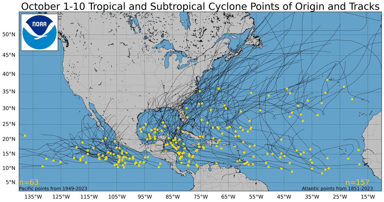
Did a three year old get a hold of this map behind the meteorologists back?😜😜
Live oaks are highly wind resistant.
The deadliest hurricane in US history did not hit Florida. It was the hurricane that hit Galveston, TX in 1900. Estimated death toll was 4000, plus it almost totally wiped out the City of Galveston. It also changed the course of Texas history. Prior to this hurricane, Galveston was the busiest and most important port in Texas, but port activity moved almost completely to Houston due to damage to Galveston.
It is clear from that map that the Deep State has been controlling the direction of hurricanes since 1949.
And they really hate Florida!
What happens to the man eating alligators. Do they get killed or survive like cockroaches being displaced in the flood waters of the neighborhoods
Let me toot my deceased Dad's horn for him. He managed parts of the Nimbus satellite program which put the very first earth-facing environmental satellite in orbit. I don't recall if he worked on Nimbus after the first two were launched.
The Nimbus satellites were second-generation U.S. robotic spacecraft launched between 1964 and 1978 used for meteorological research and development. The spacecraft were designed to serve as stabilized, Earth-oriented platforms for the testing of advanced systems to sense and collect atmospheric science data. Seven Nimbus spacecraft have been launched into near-polar, Sun-synchronous orbits beginning with Nimbus 1 on August 28, 1964. On board the Nimbus satellites are various instrumentation for imaging, sounding, and other studies in different spectral regions. The Nimbus satellites were launched aboard Thor-Agena rockets (Nimbus 1–4) and Delta rockets (Nimbus 5–7).Then Dad went on to manage the Earth Resources Technology Satellite ("ERTS") which was later renamed to "Landsat."Over a 20-year period from the launch of the first satellite, the Nimbus series of missions was the United States' primary research and development platform for satellite remote sensing of the Earth. The seven Nimbus satellites, launched over a fourteen-year period, shared their space-based observations of the planet for thirty years.
The Landsat program is the longest-running enterprise for acquisition of satellite imagery of Earth. It is a joint NASA / USGS program. On 23 July 1972, the Earth Resources Technology Satellite was launched. This was eventually renamed to Landsat 1 in 1975. The most recent, Landsat 9, was launched on 27 September 2021.The instruments on the Landsat satellites have acquired millions of images. The images, archived in the United States and at Landsat receiving stations around the world, are a unique resource for global change research and applications in agriculture, cartography, geology, forestry, regional planning, surveillance and education, and can be viewed through the U.S. Geological Survey "EarthExplorer" website. Landsat 7 data has eight spectral bands with spatial resolutions ranging from 15 to 60 m (49 to 197 ft); the temporal resolution is 16 days. Landsat images are usually divided into scenes for easy downloading. Each Landsat scene is about 115 miles long and 115 miles wide (or 100 nautical miles long and 100 nautical miles wide, or 185 kilometers long and 185 kilometers wide).
later
Are the graphs big enough for you?
Holy Moley — those stats are huge!

Better?

Precede the usual "img src" html with "img height = 400".
Scaling is easy once you get the hang of it.
I recall our good FRiend, TBP, having similar issues of magnitude in the past. Or perhaps it was a Great Wall of Text... lol
90% of what I know about html coding I learned on FReep.
And it took me about 15 years to FINALLY learn how to do image scaling.
Disclaimer: Opinions posted on Free Republic are those of the individual posters and do not necessarily represent the opinion of Free Republic or its management. All materials posted herein are protected by copyright law and the exemption for fair use of copyrighted works.