Posted on 09/12/2020 10:56:19 AM PDT by NautiNurse
The nineteenth named storm of the busy 2020 Atlantic Hurricane season developed off the southern Florida peninsula. The storm track forecast carries Sally across the southern FL peninsula into the Gulf of Mexico.
Mash the graphics below to enlarge. All links and images are self-updating.
Key West Radar Loop
Mobile AL Radar Loop
New Orleans Radar Loop
Buoy Obs Near Storm Track
Location...About 20 MI W of Pensacola FL
Max Sustained Winds...85 MPH
Moving...NNE at 4 MPH
Minimum Pressure...972 MB
Thank you for checking in and for your gracious feedback.
looks like a depression is forming in the SW Gulf now
another slow mover
My people in Gulf Shores said the eye lingered forever.
Flooding is terrible.

Location...About 15 MI WNW of Pensacola FL
Max Sustained Winds...80 MPH
Moving...NNE at 5 MPH
Minimum Pressure...975 MB
Hurricane-force winds extend outward up to 35 miles and
Tropical-storm-force winds extend outward up to 125 miles.
don’t forget about me
Possible “Medicane” to Hit Greece Later This Week
Thank you for your work.
Have never heard the term Medicane before!
Thanks. Stay high and dry. Avoid large trees with ground saturation.
I so stole that!
Where are you?
—
in Illinois :(
That medicane may be more truly tropical then usual
Oh--thought you were lounging on a sun bleached beach in the Greek Isles. I was fixing to be way jealous!
Thanks! Wow—Medicane develops a well defined eye an everything. Live and learn.
BTTT
GFS has a part the new gulf disturbance near New Orleans
however, I think that is a “convective feed back” low and the true low will be more SSW..so likely disregard
Also It is more west and slower with Teddy but still turns it well east..but I am not liking that blocking high setting up to the north..if it misses the trough then it will miss the ride NE
Plus the African wave train, or Cape Verde season, continues even to OCT 1st..it should be on it’s way down starting now (peaks in late August/ early seot..but it is 2020
and we still have the Oct Caribbean sea development part of the season too
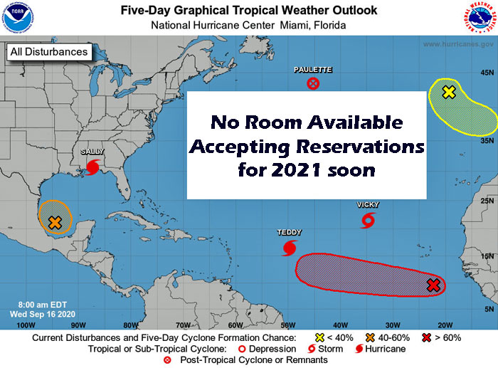
Red now (70% or greater for Gulf low)
Tropical Weather Outlook
NWS National Hurricane Center Miami FL
200 PM EDT Wed Sep 16 2020
For the North Atlantic...Caribbean Sea and the Gulf of Mexico:
T
1. Showers and thunderstorms associated with a broad area of low
pressure over the southwestern Gulf of Mexico gradually continue to
become better organized. Upper-level winds are forecast to
gradually become more conducive for further development, and a
tropical depression is likely to form late this week or over the
weekend while the low meanders over the southern Gulf of Mexico for
the next several days.
* Formation chance through 48 hours...medium...50 percent.
* Formation chance through 5 days...high...70 percent.
Disclaimer: Opinions posted on Free Republic are those of the individual posters and do not necessarily represent the opinion of Free Republic or its management. All materials posted herein are protected by copyright law and the exemption for fair use of copyrighted works.