Posted on 08/07/2020 7:46:40 AM PDT by Red Badger
The Air Force, wary of losing its GPS satellites during a major war, is exploring alternatives.
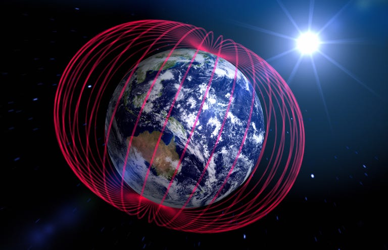
One alternative is using a magnetic field map of Earth.
Maps of Earth’s magnetic field are very accurate, but we don't know how data is gained about possible enemy territory.
===================================================================================
The U.S. Air Force, concerned that adversaries might target its fleet of GPS satellites in wartime, is looking into Earth’s magnetic field as an alternative, according to Defense One.Accurate and extremely difficult to jam, the magnetic field could be used as a means of navigation for ground troops, ships at sea, and aircraft. The magnetic field could also guide missiles to their targets with an accuracy of just over 30 feet.
The worldwide Global Positioning System (GPS), created in the late 1980s, has evolved to become an essential part of life for nearly every person on the planet. The 24 satellites that make up the GPS constellation freely provide positioning, timing, and navigational information worldwide–especially for the U.S. military. GPS allows units in the air, on land, and at sea to know their position at all times; quickly agree on a common, synchronized time; and navigate across unfamiliar terrain with relative ease.
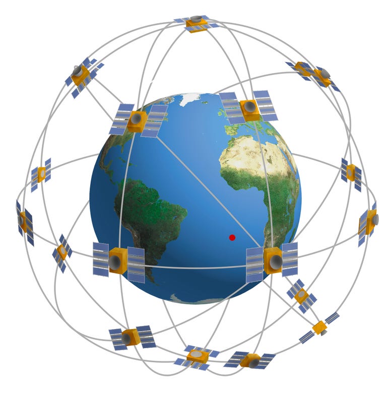
The GPS constellation visualized. QAI Publishing
he Pentagon’s reliance on GPS has made its disruption or destruction the number one priority by adversaries in wartime. Anti-satellite weapons, GPS jammers, and even GPS spoofers are designed to destroy, deny, or degrade the network, forcing U.S. and allied forces to rely on older, less accurate ways of determining their finding their way around.
Russia, China, and North Korea have all developed and deployed GPS countermeasures, some of which have interfered with civilian GPS usage. In 2019, pilots discovered Russian GPS jamming (to protect Moscow’s forces in Syria) interfering with civilian air traffic in the Eastern Mediterranean, from Cyprus to Israel.
The U.S. military has rolled out a number of alternatives to GPS, including navigating ships by sextant. One idea that seemingly holds a lot of promise: magnetic anomaly navigation techniques, or MAGNAV.
The magnetic field protecting Earth from solar winds is all encompassing, but varies by location. These variances, recorded by a magnetometer, can be correlated to a map of the planet. The result is a magnetic map of Earth that doesn’t require satellites or even a physical map.
The Joint Direct Attack Munition (JDAM) and other weapons use GPS to achieve unparalleled accuracy. These weapons are capable of traveling for miles and landing within 10 feet of their targets.
Whoever develops this tech first will win the next war.
Move 20 yards and it worked correctly.
Doesn’t the magnetic field move? The north pole has been migrating great distances.
Today’s location should be tomorrow’s location.
Probably also use some sort of on-board inertial navigation systems (e.g., ring laser gyroscopes or by fiber-optic gyroscopes.). Use magnetic field or GPS or even as you point out star field (if available!) for fine adjustments & in-flight corrections.
GPS is a modified version of my father Roger Easton’s Timation system which he started in 1964. See my book website for more details. www.gpsdeclassified.com
I wonder what Zot would have thought about this navigational development? Obviously a rhetorical question. Blessings in memory of him.
Maybe they’re replacing a system that’s been hacked by commies...
Redundancy! Plus a missile will probably fly above cloud cover and the star constellation would be visible... in the visible spectrum (not including outside the visible spectrum). Computers are very powerful these days and could triangulate within a fraction of a second.
The problem with GPS is that it can be compromised. Destroy a portion of the constellation, jam the signal...
So how does this work if the earth’s magnetic field flips during a war? It’s about due for a flip, as I understand it.
By stock in Breitling:


Just turn your maps upside down..................
Do you know why it went bonkers?
Agree !
I suspect some large iron mass underground.
The BUFF Astro Tracker was very difficult to maintain. Tube, mechanical computers and lost of components in the wheel well that were sprayed with the elements.
They put sextants back aboard our Navy’s ships here a few years back. Also reintroduced celestial navigation the Naval Academy, I think.
I suspect pilots have already bought the requisite big watch, no matter having GPS or not.
#22 I have seen my compass do that in some places in the dead stream swamp of Missaukee County, MI.
Move 20 yards and it worked correctly.
The UFO was nearby....
LOL!
I remember when doppler radar navigation was the thing in then advanced Army aircraft.
Disclaimer: Opinions posted on Free Republic are those of the individual posters and do not necessarily represent the opinion of Free Republic or its management. All materials posted herein are protected by copyright law and the exemption for fair use of copyrighted works.