Free Republic
Browse · Search
News/Activism
Topics · Post Article

Skip to comments.

Hurricane Florence Live Thread II
NHC/NOAA ^ | 12 September 2018 | NHC/NOAA

Posted on 09/12/2018 1:53:29 PM PDT by NautiNurse

The National Hurricane Center has been issuing advisories for Hurricane Florence since August 30. The five day "Cone of Uncertainty" archive progression since Aug. 30 may be found here. As the super-size storm named Florence approached the U.S. Atlantic Coast, stories abound of people who are refusing to evacuate barrier islands.

The 82nd Airborne has relocated all of its assets, while FEMA is using Fort Bragg as a major staging area for post-storm supplies, including meals, water and cots. Fort Jackson (Columbia SC) has cancelled events including basic training graduation to prepare for military and civilian evacuees from coastal locations.

While hurricane preparations are rushed to completion, some stores are closing for lack of hurricane supplies inventory. Smart phone app Gas Buddy provides updates for gasoline availability along evacuation routes.

Wave heights to 83 ft. were recorded while Hurricane Florence churned 435 miles from Wilmington, NC. Storm surge is predicted to reach 6-13 ft along the coastline to the N of landfall. Steering currents are forecast to collapse at or near landfall, resulting in Florence meandering for days. This is expected to result in up to 40 inches of rainfall in isolated areas in the Carolinas, and up to a foot of rain in the Appalachian Mountains.

Tropical Storm Isaac: The government of France has issued Tropical Storm Warnings and Watches for the Lesser Antilles.

Invest 95L: The National Hurricane Center predicts 70% chance of development in the Gulf of Mexico. Limited forecast models, satellite graphics and GOM buoy info are available for Invest 95L below.

Mash the graphics below to enlarge. All links and images are self-updating.

Hurricane Florence Isaac Invest 95L
No Forecast Cone for Invest 95L
at publication deadline

Florence Public Advisory Isaac Public Advisory
Florence Forecast Discussion Isaac Forecast Discussion
Buoy/Observations near Florence Buoy/Observations near Isaac Buoys Western GOM

National Data Buoy Center

Local Weather:
Norfolk VA
Morehead City NC
Raleigh NC
Fayetteville NC
Wilmington NC
Charleston SC/Savannah GA
Jacksonville FL
San Juan PR

Hurricane Florence & Isaac Thread I


TOPICS: Breaking News; Extended News; Front Page News; News/Current Events; US: North Carolina; US: South Carolina
KEYWORDS: braking; florence; hurricane; hurricaneflorence; hurricaneflorenceii; isaac; nautinurse; tropical
Navigation: use the links below to view more comments.
first previous 1-20 ... 201-220221-240241-260 ... 741-756 next last
To: SE Mom

Regulations are pretty specific, sympathy chocolate only for Cat 3 and above majors. Hope y’ll kept your reciepts.

:-)


221 posted on 09/13/2018 7:05:01 AM PDT by jeffers
[ Post Reply | Private Reply | To 220 | View Replies]

To: All

What kinda surprises me (and I admit I know very little about the physics of how hurricanes operate) is that I’d have thought there’d be strengthening as it approached the Gulf Stream. I thought “With all the warm water, it will either maintain its strength or grow some”.

I’m not sure what factors are sapping its strength in that its been downgraded from a Cat 4 to a Cat 2.


222 posted on 09/13/2018 7:06:32 AM PDT by MplsSteve
[ Post Reply | Private Reply | To 220 | View Replies]

To: MplsSteve

I suggested yesterday that Flo is a tired old storm, born way back on August 30.


223 posted on 09/13/2018 7:33:12 AM PDT by NautiNurse (Do not make me pay Ferrari prices for Chevy Vega health insurance.)
[ Post Reply | Private Reply | To 222 | View Replies]

To: PeteB570

There are some live cams on the Live Storm Chasers site now. https://livestormchasing.com/map


224 posted on 09/13/2018 7:38:04 AM PDT by Mama25
[ Post Reply | Private Reply | To 215 | View Replies]

To: Truth29

Thanks; we are all on edge.

><

So true.

Best wishes.

225 posted on 09/13/2018 7:38:29 AM PDT by laplata (Leftists/Progressives have diseased minds.)
[ Post Reply | Private Reply | To 190 | View Replies]

To: NautiNurse
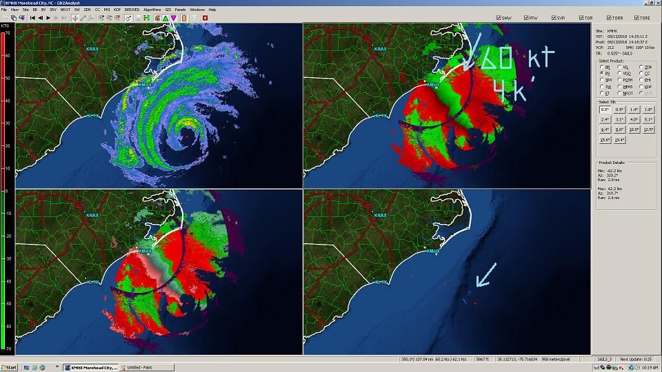
Near realtime,KMHX, Morehead City, NC

 photo 1027 Sept 13.jpg

Reflectivity, upper left, eye center 113 nautical miles from radar, Base Velocity, upper right, 62 kt wind, 4400' ASL, at blue arrow, coming ashore now, Storm Relative Velocity, using storm vector of 100 degrees at 10 kts, lower left.

Lower right, NROT, derived shear data, isolated sheer in the eyewall at blue arrow, current tornadic potential minimal.
226 posted on 09/13/2018 7:42:41 AM PDT by jeffers
[ Post Reply | Private Reply | To 223 | View Replies]

To: jeffers

Hey you!!!!! Haven’t seen you for a year...

I believe Flo was a 3 when I got the chocolate; )


227 posted on 09/13/2018 7:50:11 AM PDT by SE Mom (Screaming Eagle mom)
[ Post Reply | Private Reply | To 221 | View Replies]

To: jeffers
From 50 miles SE of eye center, up around 150,000 feet:

 photo 1047 Volumetric.jpg
228 posted on 09/13/2018 7:52:33 AM PDT by jeffers
[ Post Reply | Private Reply | To 226 | View Replies]

To: jeffers

Eyewall visibly open


229 posted on 09/13/2018 7:52:33 AM PDT by NautiNurse (Do not make me pay Ferrari prices for Chevy Vega health insurance.)
[ Post Reply | Private Reply | To 226 | View Replies]

To: jeffers

Great view of the outer bands reaching shoreline.


230 posted on 09/13/2018 7:54:07 AM PDT by NautiNurse (Do not make me pay Ferrari prices for Chevy Vega health insurance.)
[ Post Reply | Private Reply | To 228 | View Replies]

To: NautiNurse

Donald Trump has caused the storm to dissolve.

Even the weather gods shrink before the God Emperor.

#Presidentforlife #MAGA


231 posted on 09/13/2018 7:54:16 AM PDT by Jim Noble
[ Post Reply | Private Reply | To 229 | View Replies]

To: SE Mom

LTNS indeed.

Purchase vs Landfall Intensity is a gray area, I’ll check for a ruling.


232 posted on 09/13/2018 7:55:09 AM PDT by jeffers
[ Post Reply | Private Reply | To 227 | View Replies]

To: jeffers; SE Mom

Sympathy chocolate purchased at Category 3-4 earns future hurricane offsets.


233 posted on 09/13/2018 7:58:51 AM PDT by NautiNurse (Do not make me pay Ferrari prices for Chevy Vega health insurance.)
[ Post Reply | Private Reply | To 232 | View Replies]

To: NautiNurse

Here she comes... gotta say, the forecasters have nailed this one from quite a long ways out.


234 posted on 09/13/2018 8:00:40 AM PDT by alancarp (George Orwell was an optimist.)
[ Post Reply | Private Reply | To 199 | View Replies]

To: NautiNurse

Eyewall IS open but...

From 1402Z thru 1440Z, there is significant development towards full closure.

From 1440Z thru present, the new structure weakens, and the entire eyewall visibly increases diameter.

ERC?


235 posted on 09/13/2018 8:03:02 AM PDT by jeffers
[ Post Reply | Private Reply | To 229 | View Replies]

To: abb; abbi_normal_2; aberaussie; abner; AbsoluteGrace; alancarp; Alas Babylon!; Alia; ...

SUMMARY OF 1100 AM Advisory...
----------------------------------------------
About 145 MI...ESE of Wilmington NC
About 195 MI...E of Myrtle Beach SC
Maximum Sustained Winds...105 MPH
Present Movement...NW at 10 MPH
Minimum Central Pressure...955 MB...

Hurricane-force winds extend outward up to 80 miles from
the center and tropical-storm-force winds extend outward up to 195
miles.


On/Off Hurricane List Mash Here-->

236 posted on 09/13/2018 8:04:32 AM PDT by NautiNurse (Do not make me pay Ferrari prices for Chevy Vega health insurance.)
[ Post Reply | Private Reply | To 1 | View Replies]

To: NautiNurse; SE Mom

Ima let y’all handle the subclauses and where-aseszz.

Yardwork, setup, and studio client due here at 7pm.

In and out till we wrap at 11p, focus on NROT and tornadic potential, then in solid till coffee quits working.


237 posted on 09/13/2018 8:07:17 AM PDT by jeffers
[ Post Reply | Private Reply | To 233 | View Replies]

To: NautiNurse

238 posted on 09/13/2018 8:08:46 AM PDT by Red Badger (July 2018 - the month the world learns the TRUTH......Q Anon.......Timelines change. Aug 16)
[ Post Reply | Private Reply | To 236 | View Replies]

To: NautiNurse

Cape Hatteras twitter film from an hour ago

https://twitter.com/jeffhampton56/status/1040242850787717120


239 posted on 09/13/2018 8:09:02 AM PDT by KC Burke (If all the world is a stage, I would like to request my lighting be adjusted.)
[ Post Reply | Private Reply | To 223 | View Replies]

To: NautiNurse

240 posted on 09/13/2018 8:09:50 AM PDT by Red Badger (July 2018 - the month the world learns the TRUTH......Q Anon.......Timelines change. Aug 16)
[ Post Reply | Private Reply | To 236 | View Replies]


Navigation: use the links below to view more comments.
first previous 1-20 ... 201-220221-240241-260 ... 741-756 next last

Disclaimer: Opinions posted on Free Republic are those of the individual posters and do not necessarily represent the opinion of Free Republic or its management. All materials posted herein are protected by copyright law and the exemption for fair use of copyrighted works.

Free Republic
Browse · Search
News/Activism
Topics · Post Article

FreeRepublic, LLC, PO BOX 9771, FRESNO, CA 93794
FreeRepublic.com is powered by software copyright 2000-2008 John Robinson