
Posted on 09/09/2018 8:01:18 AM PDT by NautiNurse
September 10 is the statistical peak of the Atlantic Tropical Storm season, and the conga line of storms dancing across the Atlantic is not disappointing historical data. The Governors of NC and SC have declared states of emergency for a potential major hurricane landfall, while Hurricane Florence is slowly creeping westward. Florence is predicted to increase forward motion and intensity Monday. Hurricanes Hazel (1954) and Hugo (1989) are two notorious major hurricanes to make landfall in NC and SC, respectively. North Carolina has prior experience with "F" named hurricanes. Hurricanes Fran (1996) and Floyd (1999) caused widespread flooding and damage in the Tar Heel state.
The NHC has been issuing Public Advisories for Florence since August 30. The five day "Cone of Uncertainty" archive progression since Aug. 30 may be found here.
Isaac is a small storm. Isaac is predicted to steadily strengthen during the next few days as the storm remains over warm waters and in a low wind shear environment in the short term. The NHC predicts Isaac will reach hurricane status within 2 days.
Helene is expected to reach hurricane status in the short term. However, Helene is not anticipated to threaten U.S. interests. The forecast track turns north into the mid-Atlantic.
Click on the images below to enlarge

If I read Twitter feed correctly, Joe B. posted it on Sunday 9/9 early afternoon...
Uhhhh, it's now called: "CLIMATE CHANGE" and it causes EVERYTHING bad, even if nothing happens!
Earth's Gaia's only hope, of course, is VOLUNTARY HUMAN EXTINCTION, staring with all DENIERS.
Flooding is exactly what I’m worried about. Florence could be a monster
I remember when Sandy was approaching. It was right before Halloween, and the NY Post had a cover that showed how massive it was, with this cover on October 28th.
Hurricanes do boomerang. Ivan did.
I think Joe Bistardi is in his early 60s. I hear he lifts weights and is in very good shape.
Good advice.
What always amazes me are the number of people who have generators, and they only have 5 or so gallons of gas on hand (some with less). They run their generator when the power goes out for a few hours, and then are amazed it uses gasoline. So they drive to their nearest gas station, and find out the power is out there too and the pumps don't work. So they drive some more. And drive some more. Finally, they find a gas station with power. And then they are amazed, angry, and hurt that there are huge lines with people trying to fill their cars and gas containers.

Realistically, I believe you need about 25 - 30 gallons on hand. I keep mine with Sta-bil in 5 gallon containers.
I put the date filled on each container, and use the oldest gas first for the mower, leafblowers, etc. You can pour it into your car's gastanks and get fresh after 6 months to keep the gas new.
A relative of mine when out after Sandy looking for red gas containers, because he only had 2 gallons of gas for his generator. When the generator went out, his wife freaked out and told him to get more gas. He went to every hardware store he could find looking for gas containers. They laughed at him.
Updated within the last hour. Looks like current tracking is a still a direct hit near Wilmington, NC.
![]()
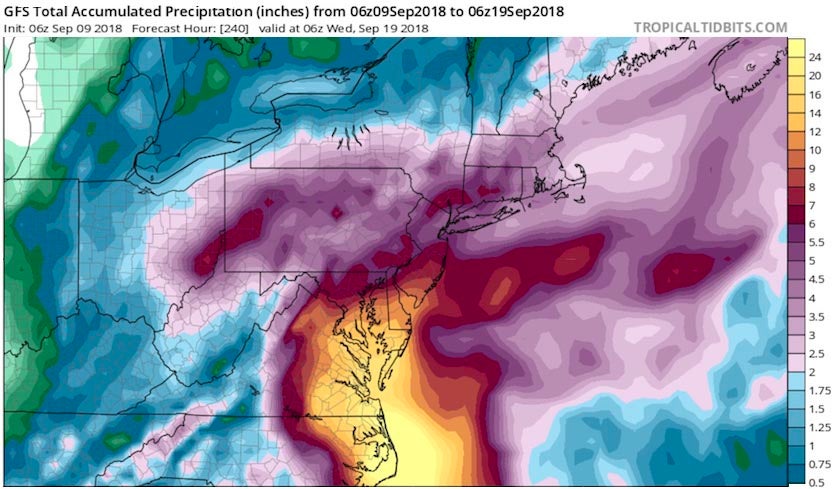
Here is the latest forecast:
HWRF model winds and pressure forecast for 11 pm EDT Thursday, September 13, from the 6Z Sunday run of the model. The HWRF model was our top intensity model from 2017, and predicted that Florence would make landfall near Wilmington, North Carolina as a Category 3 hurricane.

Drudge is now tweeting out the same info as Joe Bastardi's prediction:
-----------------------------------------------------

MATT DRUDGEVerified account @DRUDGE
Hurricane Florence may end up being the worst natural disaster in recorded history for the Carolinas and Virginia. 3 to 4 feet of rain, IF predictions hold! BIG news week developing...
I’m seeing less “the Carolinas” and more “North Carolina/Virginia” here.
I wish there were an easy way to compare path and wind history with Hurricane Isabel, looks like it’s on a very very similar path with similar intensity.
Like Harvey did last year in Houston.
Keep in mind the storm was well over 1000 miles away...
Probably Wednesday. Restaurants had stopped ordering food so you get what you get.
The NOAA G-IV jet is conducting another synoptic surveillance
mission this morning in support of the 1200 UTC model cycle, and
these flights will continue through Tuesday.A NOAA P-3 Hurricane Hunter aircraft is also scheduled to conduct
a research mission into Florence this morning, with Air Force C-130
fix missions beginning late this afternoon.Additional upper-air data are being collected across portions of the
central and eastern U.S. via special 0600 UTC and 1800 UTC
radiosonde launches. Hopefully these data will help improve the
track and intensity forecasts.
My guess is landfall will deviate some several times before it actually hits,would be strange if it didn’t,major storms take on a life of their own after a while and even a wobble can change the target zone.
Even the 48 hour forecast could easily be off 6 mph making it a five if even for a short period.
Glad to hear it, thanks.
Disclaimer: Opinions posted on Free Republic are those of the individual posters and do not necessarily represent the opinion of Free Republic or its management. All materials posted herein are protected by copyright law and the exemption for fair use of copyrighted works.


