Posted on 08/24/2017 8:44:29 AM PDT by NautiNurse
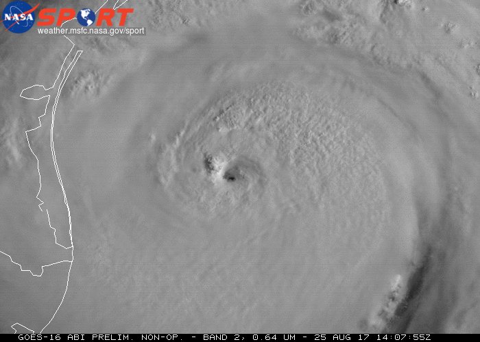
Potentially catastrophic Hurricane Harvey approaching Texas Gulf Coast.


Mash image to find lots of satellite imagery links
Public Advisories
NHC Discussions
NHC Local Hurricane Statements Corpus Christi
NHC Local Hurricane Statements Galveston
Buoy Data near Harvey

Leadership and lack of leadership....
Relatives, in CC, packed up and left for the hills, yesterday.
They left early enough to avoid most of the traffic, thankfully.
Notice some buses are for black people only, others are for mixing black and white...
I had to laugh at the bus colors...in this. Crazy time we live with the ridiculous racial tensions, some jokes can’t be ignored.
Glad they got out....
Here where I live In PA there’s little that would threaten safety....but if ever needed to leave the school house is on the Hill two blocks from me.... walking distance....
We have more problems with winter snow storms shutting things down ...ice and such....power outages. Rain storms can get loud with flash flooding but I’m well above that.
Trust you’re going to be ok throughout this....going to get ‘loud’ I think.
One in Matagorda County.
Bob Hall Pier is the first land-based station I’ve seen with tropical storm force winds ... 42 m.p.h.
That map has nothing to do with winds actually being experienced. It’s nothing more than:
1. Probable track of storm;
2. Probable classification of storm;
3. Storm warnings and watches;
4. New this season, estimated extent of storm force winds (local results WILL vary).
Port Aransas reporting 41 m.p.h.
EVERYONE stay safe in Texas!!
In NYC, the only hurricane force winds we usually have to worry about come from Deblasio’s mouth.
Sending prayers out.


Prepped and squared away. Got guac, chips, beer and charcoal.

Beautiful shots. Of course, when photos start to look like spooky paintings, you’re about to catch hell...

The Climate Changes Zealots are going to do their best to make this sound like Katrina II and then try to blame Trump for backing out of the Paris accord, yada, yada.
Note to non-Texans: You will see pictures of Interstate 10 underwater. It’s happened several times before. One stretch planners cleverly decided to tunnel under the cross streets on the way to downtown instead of jumping over them. Result: Floods every time there is heavy rains. Dramatic photos for the media to exploit.
If it dawdles around Houston, it will be worse than the underrated Tropical Storm Allison if 2001 in terms of damage. If the eye moves inland, though, it should peter out into a nice rain storm which we Texans will have back to normal in a week or two.
I’m hoping it comes further inland so the I-35 corridor gets a good cooling off. It’s August, after all.

Good luck! Check in with local updates when you get a chance.
On it. Have ridden out many storms since the 1960’s. And have learned lots of lessons from old timers who experienced storms from the 1930’s and on. This one looks like a mixture of Hurricane Carla from 1961 and TS Allison.

Tornado threat increasing as outer bands of #Harvey move inland. GOES16 Day Land Cloud multi-spectral RGB product.

Disclaimer: Opinions posted on Free Republic are those of the individual posters and do not necessarily represent the opinion of Free Republic or its management. All materials posted herein are protected by copyright law and the exemption for fair use of copyrighted works.