STATION ELEV HIGH LOW PCPN SNOW DEPTH
MOUNT LECONTE 6400 45 27 0.00 14
Posted on 03/20/2010 9:28:18 PM PDT by ThunderSleeps
Just about everyone, except the uber-faithful, now realizes global warming is perhaps the greatest hoax anyone (or any group) has ever tried to perpetrate on the world.
I offer more anecdotal evidence of said hoax.
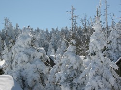
Today I happened to be driving down 25 through New Mexico, cut the corner at Las Cruces on 26, and headed west into Arizona on 10. Noted that the small (by Colorado standards) mountains around Deming NM had snow on them. Snow, in late March. Not an isolated incident. All the mountains to my left (south of 10) as I crossed into AZ had snow. The rather low ridges south of Wilcox had snow. Even the relatively big peak south of Tucson has snow. (PS, cool airshow at D-M today)
So, in mid-late March, relatively small peaks literally within sight of the US-Mexico border have snow? Some "global warming" eh? {snicker} No wonder the global warming zealots have shut up. Sheer embarrassment.
On the other hand we had a lovely day in the San Joaquin Valley in the mid-60’s, however when the Sierra’s are visible, there is quite an impressive snow pack.
I live in Dallas and I have about an inch of “global warming” left on my truck from the snow flurries we had a few hours ago.
Four new inches of snow here this morning. South Central NM, (foothills of some pretty big mountains not ON the mountains): 22F at noon, (wind chill factor around 0F.) 18F now at 10:30PM.
I could use some of AlGore’s warming.
I see those mountains everyday and I have lived here for 50 years and can say that this has never happened before, there has been snow on the mountian for 114 day.
I live just West of the DFW airport, between Dallas and Ft. Worth. Rained over an inch Saturday and then began snowing here a little after 6 pm. Six hours later, I had over 2 inches of snow on my place. First day of Spring?
So, in mid-late March, relatively small peaks literally within sight of the US-Mexico border have snow? Some "global warming" eh? {snicker} No wonder the global warming zealots have shut up. Sheer embarrassment.
It's called the last gasp of winter around here in Oklahoma, it happens all the time... doncha know... LOL ...
Office of Governor Brad Henry
State of Oklahoma
State Capitol - Oklahoma City OK 73105
(405) 521-2342
State of Emergency Declared in Preparation for Winter Storm
March 19, 2010
Oklahoma City — State officials declared a state of emergency late Friday in all 77 of Oklahoma’s counties in preparation for a blizzard forecast in Oklahoma expected to bring snow and frigid temperatures to much of the state, as well as the potential for ice or flooding in some areas.
At the request of Gov. Henry, Lt. Gov. Jari Askins approved the paperwork declaring the emergency.
The declaration provides a formal mechanism for local governments to seek reimbursement for recovery costs through the state’s disaster public assistance program should conditions warrant. The executive order is also the first step toward seeking federal aid should it be necessary.
Gov. Henry is on a family trip to Colorado and is returning to the state on Saturday.
The State Emergency Operations Center will be activated by the Oklahoma Department of Emergency Management at 7:00 a.m. on Saturday morning.
For more information contact:
Michelann Ooten, Oklahoma Emergency Management, 405-205-1879
Thomas Larson, Press Secretary for Gov. Brad Henry, 405-301-6357
We've had these March snowstorms forever around here... :-)
I live just West of the DFW airport, between Dallas and Ft. Worth. Rained over an inch Saturday and then began snowing here a little after 6 pm. Six hours later, I had over 2 inches of snow on my place. First day of Spring?
You just got some of that "spillover" from Oklahoma, that's all... LOL ...


This is for accumulations from Friday night to Saturday night...

I live in Dallas and I have about an inch of “global warming” left on my truck from the snow flurries we had a few hours ago.
That's just "left-overs" from Oklahoma... no worries there... :-)
Spring may have to wait in state
BY BRYAN PAINTER
Published: March 19, 2010
Oklahoma has a very fresh memory of the fact that the end of winter does not mean the end of wintry weather.
Spring officially begins Saturday, but it may just be a continuation of winter in Oklahoma.
A winter storm watch is in effect from Saturday morning to Sunday morning. Temperatures Saturday may be about 35 to 40 degrees cooler than today’s high temperatures. Strong north winds are expected to drop wind chills into the teens and 20s in most areas Saturday.
Snow appears likely near and north of Interstate 40 in the western two-thirds of the state. Local amounts over 8 inches are forecast for north-central Oklahoma, with a threat of dropping into central Oklahoma, the weather service said.
Other areas could see accumulations of more than 4 inches, according to the National Weather Service. Wind gusts over 45 mph will produce blowing and drifting snow, and blizzard conditions may exist at times, the weather service said.
Before the snow, though, rain and thunderstorms are expected to break out along a cold front this afternoon in southwest, west-central and northern Oklahoma, with winds of 30 mph gusting over 40 mph. It should spread east and south tonight as cold air plunges deeper into the region, the weather service said.
The timeline and intensity of a winter storm changes rapidly, making it important to continue to monitor the weather, said Mike Foster, meteorologist in charge of the National Weather Service, Norman Forecast Office.
"This winter has been very active with record or near-record snow and ice events, each of which has presented very complex forecast problems,” he said. "The storm expected to impact us Friday and Saturday, is no exception.
"This very dynamic late winter storm will produce snow for many locations, but the amount at any spot will depend on small scale moisture and temperature details, which are still to be determined.”
Just a year ago, areas of Oklahoma received a state record dose of snow, a few days into spring.
On March 27-28, 2009, portions of northwest Oklahoma received more snow in a 24-hour period than any time since records began in 1892, with official measurements of 26 inches at Woodward and Freedom. Unofficial totals were even greater. The hardest hit areas in Oklahoma were in the extreme northwest as well as into the Panhandle.
Accumulations are not expected to reach those proportions. But, winter is expected to end with some of the same intensity it has displayed for months. And thus stores may see increased activity.
"We will sell a lot of milk and other groceries tomorrow for two reasons,” Terry Holden, a Braum’s spokesman said Thursday. "First, everybody who was going to come in Saturday will move it up a day. Second, folks do store up before bad weather.”
This winter’s weather
The winter of 2009-10 was not the coldest in Oklahoma history. It will end somewhere in the middle of the pack.
And, it was not the wettest, ranked at 23rd statewide going into Thursday.
"However, the cold and wet weather seemed to coincide at the most inopportune times to produce more bouts with frozen precipitation than we have seen in recent years,” said Gary McManus of the Oklahoma Climatological Survey.
Two storms definitely stand out, the Christmas Eve blizzard and the Jan. 28-29 ice storm.
"One of the strangest things about this winter, as it turns out, was not the cold weather but the lack of any substantial warm weather,” McManus said. "Oklahoma winters tend to be mild with intermittent bouts of frigid weather and pleasantly warm weather. The really cold weather showed, but the pleasantly warm weather was largely absent.”
With 20.7 inches of snow this winter, Oklahoma City enters the upcoming storm 4.5 inches short of tying its record.
Also this winter, temperatures in Oklahoma City dipped as low as 6 degrees on Jan. 10 and failed to reach 70 degrees, coming close with 69 degrees on March 5.
The highest temperature recorded this winter was 75 degrees at both Hollis and Waurika. The Oklahoma Mesonet failed to record a 70-degree temperature during February for the first time since the network’s inception in 1994.
The southern half of the state received far more moisture than did the northern half, McManus said. Up to 16 inches of precipitation fell in the southeast compared to just over 2 inches in the extreme northwest.
"That is a signature of an El Nino-influenced precipitation pattern,” McManus said.
Will spring arrive?
Eventually spring weather will show up.
But what will that mean this year?
The National Oceanic and Atmospheric Administration’s Climate Prediction Center says odds currently favor wetter-than-normal conditions in the Panhandle and northwestern Oklahoma and below-normal temperatures throughout most of the state.
![]()
LOL, Star...
The maps aren’t accurate, though. 10 pm news showed it snowing in Waxahatchi about 20-25 miles South of Dallas. The maps don’t even show snow as far South as the DFW area.
If the DFW airport recorded 1.8 inches, it will set a record for snowfall in the area during a Winter season. We were already over 16 inches.
That’s partly why I posted. Wondering where all that GW went, and if this kind of thing is normal. I live a little north of here. Just seems odd to me to see snow within spitting distance of our southern border this late in winter.
I’m on Galveston Bay, south of Houston and it almost froze last night! 34 degrees at 6am, no wonder the tomato plants are not happy!
If the DFW airport recorded 1.8 inches, it will set a record for snowfall in the area during a Winter season. We were already over 16 inches.
Well, here are some statistics from the last snowstorm that y'all had...
7:10 PM Thu, Feb 11, 2010
Jason Sickles/Editor
Updated @ 4:55 a.m. Friday, Feb. 12
The record fell at 6:57 p.m. with it still snowing and the winter storm warning extended until 6 a.m. Friday. While the official record is measured at Dallas-Fort Worth International Airport, many local cities saw just as much or more.
Greatest snowfall in one calendar day
That’s partly why I posted. Wondering where all that GW went, and if this kind of thing is normal. I live a little north of here. Just seems odd to me to see snow within spitting distance of our southern border this late in winter.
Well, I've posted on a lot of those Global Warming threads... and to somewhat sum it up for the posts, without giving the full details here, basically it's that "Anthropogenic Global Warming" is the false issue, as that's not backed up by legitimate science.
However, "Global Warming" and "Global Cooling" is normal and it happens all the time. So, we've had Global Warming and we've had Global Cooling, but not "Anthropogenic Global Warming"...
In fact, we were in a Global Warming spell for the last many decades that I can remember, warming up quite a bit, from my early life. And now..., we've shifted from that Global Warming to a Global Cooling phase. After that, we'll go back to Global Warming once again...
And heck, I might as well post one of those articles that I have, with that nice graph on it... :-)
Until recently, global temperatures were more than a degree Fahrenheit warmer when compared to the overall 20th Century mean. From August of 2007 through February of 2008, the Earth’s mean reading dropped to near the 200-year average temperature of 57 degrees. Since that time, the mean reading has been fluctuating.
We, Cliff Harris and Randy Mann, believe that the warming and even the cooling of global temperatures are the result of long-term climatic cycles, solar activity, sea-surface temperature patterns and more. However, Mankind’s activities of the burning of fossil fuels, massive deforestations, the replacing of grassy surfaces with asphalt and concrete, the ‘Urban Heat Island Effect,’ are making conditions ‘worse’ and this will ultimately enhance the Earth’s warming process down the meteorological roadway in the next several decades.

From the late 1940s through the early 1970s, a climate research organization called the Weather Science Foundation of Crystal Lake, Illinois, determined that the planet’s warm, cold, wet and dry periods were the result of alternating short-term and long-term climatic cycles. These researchers and scientists also concluded that the Earth’s ever-changing climate likewise has influenced global and regional economies, human and animal migrations, science, religion and the arts as well as shifting forms of government and strength of leadership.
Much of this data was based upon thousands of hours of research done by Dr. Raymond H. Wheeler and his associates during the 1930s and 1940s at the University of Kansas. Dr. Wheeler was well-known for his discovery of various climate cycles, including his highly-regarded ‘510-Year Drought Clock’ that he detailed at the end of the ‘Dust Bowl’ era in the late 1930s.
During the early 1970s, our planet was in the midst of a colder and drier weather cycle. Inflationary recessions and oil shortages led to rationing and long gas lines at service stations worldwide. The situation at that time was far worse than it is now, at least for the time being.
The Weather Science Foundation also predicted, based on these various climate cycles, that our planet would turn much warmer and wetter by the early 2000s, resulting in general global prosperity. They also said that we would be seeing at this time widespread weather ‘extremes.’ There’s little doubt that most of their early predictions came true.
Our recent decline in the Earth’s temperature may be a combination of both long-term and short-term climate cycles, decreased solar activity and the development of a strong long-lasting La Nina, the current cooler than normal sea-surface temperature event in the south-central Pacific Ocean. Sunspot activity in the past 18 months has decreased to the lowest levels since ‘The Little Ice Age’ ended in the mid-to late 1800s. This "cool spell," though, may only be a brief interruption to the Earth’s overall warming trend. Only time will tell.
Based on these predictions, it appears that much warmer readings may be expected for Planet Earth, especially by the 2030s, that will eventually top 1998's global highest reading of 58.3 degrees. It’s quite possible we could see an average temperature in the low 60s. Until then, this ‘cooling period’ may last from just a few months to as long as several years, especially if sunspot activity remains very low.
We at Harris-Mann Climatology, www.LongRangeWeather.com, believe that our prolonged cycle of wide weather ‘extremes,’ the worst in at least 1,000 years, will continue and perhaps become even more severe, especially by the mid 2010s. We should see more powerful storms, including major hurricanes and increasing deadly tornadoes. There will likewise be widespread flooding, crop-destroying droughts and freezes and violent weather of all types including ice storms, large-sized hail and torrential downpours.
We are already seeing on virtually every continent an almost Biblical weather scenario of increasing droughts and floods. In both the southwestern and southeastern corners of the U.S, there are severe water shortage problems associated with chronic long-term dryness. In some cases, the water deficits are the worst in at least 400 years.
Dr. Wheeler also discovered that approximately every 102 years, a much warmer and drier climatic cycle affects our planet. The last such ‘warm and dry’ peak occurred in 1936, at the end of the infamous ‘Dust Bowl’ period. During that time, extreme heat and dryness, combined with a multitude of problems during the ‘Great Depression,’ made living conditions practically intolerable.
The next ‘warm and dry’ climatic phase is scheduled to arrive in the early 2030s, probably peaking around 2038. It is expected to produce even hotter and drier weather patterns than we saw during the late 1990s and early 2000s.
But, we should remember, that the Earth’s coldest periods have usually followed excessive warmth. Such was the case when our planet moved from the Medieval Warm Period between 900 and 1300 A.D. to the sudden ‘Little Ice Age,’ which peaked in the 17th Century.
By the end of this 21st Century, a big cool down may occur that could ultimately lead to expanding glaciers worldwide, even in the mid-latitudes. We could possibly see even a new Great Ice Age. Based on long-term climatic data, these major ice ages have recurred about every 11,500 years. Well, you guessed it. The last extensive ice age was approximately 11,500 years ago, so we may be due. Again, only time will tell.
The Weather Channel lists OKC in the Top 10 of U.S. bad-winter cities.
By SARA PLUMMER World Staff Writer
Published: 3/19/2010 2:23 AM
Last Modified: 3/19/2010 4:58 AM
With nearly 21 inches of snow already recorded this winter season, Oklahoma City was among the Weather Channel's 10 worst winter-weather cities for 2009-10.

Robert Eliot waits on a tow truck after he lost control of his car on U.S. 75 near the 46th Street North exit on March 28, 2009. Tulsa, within reach of a record this year, could see snow Saturday. STEPHEN HOLMAN/Tulsa World file
Oklahoma City, only 100 miles from Tulsa, has had nearly 4 more inches of snow than Tulsa this winter, said Chuck Hodges, a meteorologist with the National Weather Service.
The biggest difference was Oklahoma City's 13.5 inches of snow on Christmas Eve and Christmas compared with the nearly 6 inches Tulsa saw.
The Weather Channel based its rankings on weather conditions and socioeconomic-related variables from Dec. 1 through Feb. 28 compared with averages of 30-year climatological data.
But meteorologists know that despite spring's official start Saturday, snow totals for both cities this season aren't set in stone yet.
National Weather Service meteorologist Kenneth Jackson said, "Some of our biggest snowstorms come in March."
Last year in Tulsa, 10.4 inches of snow fell in March, 6 inches of that in one day. In 1994, more than 14 inches of snow fell in the city in March.
"Every year, we've had something — either a trace (of snow) or a couple inches," Jackson said.
Snow is likely in Oklahoma in early spring because more moisture makes its way north from the Gulf of Mexico while northern cold fronts still come this far south, Jackson said.
And even though it happens every year, snow in March still surprises Oklahomans.
"We warm up to the 50s and 60s (and) you think winter's over," Jackson said. "It can swing from one extreme to another. It's Oklahoma weather."
The temperature extremes will be evident this weekend. Friday's springlike temperatures are expected to give way to thunderstorms and a cold front Saturday with a chance for snow, according to the National Weather Service.
The warm, fast southern winds from the Gulf of Mexico could actually increase the chance of snow because of all the moisture they bring, Jackson said.
After so much snow this winter, it might as well keep coming, he said.
"We might as well break the record if we can," Jackson said of Tulsa's 25.6-inch record, which was set in the winter of 1923-24. "It would have to be like last March."
With Tulsa sitting on 17.1 inches of snow this season, it would take more than 8 inches for that to happen. Official snowfall is measured at Tulsa International Airport.
If snow does accumulate Saturday, don't expect school to be closed Monday, Jackson said. Spring snowfalls rarely stick around.
"It's there, and the next day it's gone," he said.
10 worst winter-weather cities of 2009-10
* tied
Source: The Weather Channel
Disclaimer: Opinions posted on Free Republic are those of the individual posters and do not necessarily represent the opinion of Free Republic or its management. All materials posted herein are protected by copyright law and the exemption for fair use of copyrighted works.