| This thread has been locked, it will not receive new replies. |
|
Locked on 09/24/2005 10:02:57 AM PDT by Admin Moderator, reason:
Thread VIII: http://www.freerepublic.com/focus/f-news/1490587/posts |
Posted on 09/23/2005 8:01:35 PM PDT by NautiNurse
Hurricane Rita landfall is anticipated within the next few hours. Strong winds and heavy rains are battering southern Louisiana and southeastern Texas.
MSM news crews are shouting over the howling winds as they foolishly describe blowing rain, swaying trees, and crashing waves through rain splattered camera lenses. It's a hurricane. We know these things already.
An 18 wheeler rig reportedly overturned on an I-10 bridge. The fate of the truck driver is unknown at this time. Reports of widespread power outages in Lake Charles. KPLC-TV Lake Charles local news has remarkably improvised their reporting from a remote location. They are taking calls from residents, NWS, and public utility representatives, and alerting residents to local conditions.
On the flip side, CNN announced to the world that law enforcement officers had evacuated from Port Arthur TX with the rest of the population. Engraved looter invitations would have been more elegant.
Godspeed to all those in the path of this storm.
The following links are self-updating:
Public Advisory Currently published every 3 hours 5A, 8A, 11A, 2P, etc. ET
NHC Discussion Published every six hours 6A, 11A, 6P, 11P
Three Day Forecast Track
Five Day Forecast Track
Rita Forecast Track Archive
Forecast Models
Buoy Data Western Gulf of Mexico
Houston/Galveston/Beaumont/Lake Charles Wx Watches/Warnings
Jefferson Co TX NWS Weather
Current Weather Warnings and Watches for Texas
Current Weather Warnings and Watches for Louisiana
Hi Res Houston Flood Zone Map Slow load, great detail
Images:
Lake Charles Long Range Radar Still image, with loop link
Houston/Galveston Long Range Radar Still image, with loop link
Lake Charles Experimental Radar Outages and Delays May Occur
Storm Floater IR Loop
GOM WV Loop
GOM IR Still Image
Visible Storm Floater Still (only visible during daylight hours)
Color Enhanced Atlantic Loop
Streaming Video: (coverage may be intermittent)
KHOU-TV/DT Houston
KPRC-TV/DT Houston
KTRK-TV/DT Houston
KTRH-AM Houston
KPLC-TV/DT Lake Charles/Lafayette
KSLA-TV/DT Shreveport
Additional Resources:
FReeper Sign In Thread Check in to let us know whether you are staying, going, and when you get there
FReepers Offering Lodging To Rita Evacuees People and/or Pet Friendly FReepers Offering Shelter
KHOU Houston
KTRK ABC News Houston
KPLC Lake Charles Evac Routes, news
KFDM Beaumont/Port Arthur News, evac info
Hurricane City
Wxnation Houston
Galveston Webcams
Golden Triangle Weather Page Provides Galveston Weather, Warnings, Radar, etc.
| Category | Wind Speed | Barometric Pressure | Storm Surge | Damage Potential |
|---|---|---|---|---|
| Tropical Depression |
< 39 mph < 34 kts |
Minimal | ||
| Tropical Storm |
39 - 73 mph 34 - 63 kts |
Minimal | ||
| Hurricane 1 (Weak) |
74 - 95 mph 64 - 82 kts |
28.94" or more 980.02 mb or more |
4.0' - 5.0' 1.2 m - 1.5 m |
Minimal damage to vegetation |
| Hurricane 2 (Moderate) |
96 - 110 mph 83 - 95 kts |
28.50" - 28.93" 965.12 mb - 979.68 mb |
6.0' - 8.0' 1.8 m - 2.4 m |
Moderate damage to houses |
| Hurricane 3 (Strong) |
111 - 130 mph 96 - 112 kts |
27.91" - 28.49" 945.14 mb - 964.78 mb |
9.0' - 12.0' 2.7 m - 3.7 m |
Extensive damage to small buildings |
| Hurricane 4 (Very strong) |
131 - 155 mph 113 - 135 kts |
27.17" - 27.90" 920.08 mb - 944.80 mb |
13.0' - 18.0' 3.9 m - 5.5 m |
Extreme structural damage |
| Hurricane 5 (Devastating) |
Greater than 155 mph Greater than 135 kts |
Less than 27.17" Less than 920.08 mb |
Greater than 18.0' Greater than 5.5m |
Catastrophic building failures possible |
Previous Threads:
Hurricane Rita Live Thread, Part VI
Hurricane Rita Live Thread, Part V
Hurricane Rita Live Thread, Part IV
Hurricane Rita Live Thread, Part III
Hurricane Rita Live Thread, Part II
Hurricane Rita Live Thread, Part I
Tropical Storm Rita
Tropical Depression 18
I think they must have had a gross of them in the truck for him.
KPRC 2 stream just had a report of a building collapse in Galveston. Still too dark to show much.
All electric appears out, except in downtown.
Building appeared to be a 2 story older building that housed a restaurant.
[We'll see more of this when daylight comes, winds die down, and helo's get to fly cameras around. We initially got reports after Katrina that the damage didn't seem too bad -- until overflights told a different story.]
Good morning, NautiNurse, and others. Thanks for the work on the threads.
Just your average android.
News from Houston: 28 confirmed burglaries ("looting"), 16 arrests. Houston has a dedicated task force assigned to finding and catching looters for the duration of the hurricane, and apparently they're doing a good job. There's video on Channel 13 now of a car that had crashed into a tree (pretty hard, from the looks of it) when the police caught some folks looting a Wal-Mart and they tried to get away.
midway between Jasper and Beaumont according to above after coming ashore as a 3
Just got answer. This is part of BC spillway. Locks on the Miss can be opened for water to exit the River above NO and go thru a big swath of the land, spillway, and go into Lake Ponchatrain.
I wonder if this means that water from the Lake going over those levees is Miss River water.
I haven't heard this before so it is in the area of rumor, maybe false. People outside NO should be able to see and report it if so.
Good morning...and now I must bid you all adieu. Headed north to cooler weather for a few days.
I've heard of the locks. And I've also heard that, somehow, they regulate between the lake and the river. My understanding has always been that one or the other could be used to pump to depending on which source was the problem. I'm not more educated than that. The river hasn't been a problem so far. But, as someone pointed out, there will be rain water coming from everywhere north and into the river.
Thanks for keeping the threads going.
thanks for your hard work.
Mornin.
The old 1700 Thur graphic is still up at
http://i4.photobucket.com/albums/y138/jeffers_mz/02J.jpg
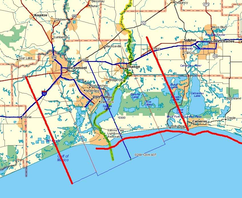
It's a little dated but I have a newer one, zoomed on Orange, Beaumont, and Port Arthur, at:
http://i4.photobucket.com/albums/y138/jeffers_mz/Rita/o4landfallmap.jpg
It's quick and dirty, no legends, but based on the last pre and first post storm plots so it's accurate.
Heavy straight red = outer eyewall boundaries
skinny straight red =inner eyewalls
Heavy wavy red = max surge effect
blue = the linear interpolated eyecenter track
I'm pulling down DEMs right now, looking to have surge projections at 15 and 20 feet for Beaumont, Port Arthur, Orange, and Lake Charles, ETA two hours. Maybe less, many areas don't have 10 meter data so the downloads are going faster.
The river is low now, it can take the rain.
Fox is covering a lot on Lake Charles - they have a guy on the parking deck of that new casino.
I did not see Geraldo fall - but Shep took a spill last night... and his hat flew off. ;)
Glad to see you're posting!
Not exactly sure where the eye is right at this moment - TV is in the other room.
Safe travels.
Cool...:-) One less thing.
Looking for a hard location on NO levee breaches.
Got 9th ward, looking especially for reports from London Canal or any other affecting downtown New Orleans.
Rebuilding NOLA in its current form is madness. The only thing I can think of that would be more impracticle and less viable is building a city at the foot of a volcano and constructing an elaborate awning system to keep the ash and lava off.
THANK YOU so MUCH for all your hard work!!!!! Have a nice cool weekend!
Disclaimer: Opinions posted on Free Republic are those of the individual posters and do not necessarily represent the opinion of Free Republic or its management. All materials posted herein are protected by copyright law and the exemption for fair use of copyrighted works.