Skip to comments.
Is LA Governor Blanco Hiding "Imaginary" Levees? (4 x 100 KB images)
Posted on 09/14/2005 4:39:47 PM PDT by jeffers
Several media sources have reported that LA Governor Kathleen Blanco resisted and delayed federal efforts to send aid and relief to southern Louisiana, expressing concern that if the federal government became involved, they would lay all the blame on state and local officials. This is a matter of public record. What has yet to come to light are any details which might explain Governor Blanco's apparant insecurity.
This article from The New Orleans Times-Picayune, dated June 23, 2002, notes the following significant points:
1. The New Orleans area's last line of defense against hurricane flooding is a 475-mile-long system of levees, locks, sea walls and floodgates averaging about 16 feet high. The Army Corps of Engineers says the system will protect the city and suburbs from a Category 3 hurricane that pushes in enough seawater to raise Lake Pontchartrain 11.5 feet above sea level -- high over the head of anyone standing on the other side of a levee.
That margin of error is critical because a storm that pushes the lake any higher can force water over the top of the levees and inundate the city. The water could quickly rise 20 feet or higher. People would drown, possibly in great numbers.
The corps doesn't know what that safety margin is anymore. Generally speaking, the corps says the powerful, slow-moving storms capable of overwhelming the system are rare and the levees are safe. But corps engineers say their own safety estimates are out of date, and an independent analysis done for The Times-Picayune suggests some levees may provide less protection than the corps maintains.
2. Measuring the risks of disaster is a technical feat that few understand. But such exercises are critical to the future of New Orleans. If the new corps study confirms that protection is less than previously thought, the answers could have major effects on issues such as flood insurance rates, future levee expansions, emergency planning, evacuation and long-term business decisions.
3. The landscape also is changing because of coastal erosion, sinking and even levee building.
4. Levee heights along the Mississippi River-Gulf Outlet and Intracoastal Waterway in the area range from 17.5 to 19 feet. Butler's estimates put the 100-year flood level at 16.3 feet above sea level, meaning waves on top of that would wash over the top and flood areas inside.
The historical record tends to confirm these results, Butler said. "All along the levee, there has been very high water measured there for several storms, certainly in Betsy. If you had the right kind of storm come in there, you'd really be in trouble."
http://homepages.uc.edu/~maynarjb/105/NewOrleans/NewOrleans_hurricanes.htm
In 1999, NASA launched shuttle mission STS-99, a 17 day effort which mapped over 80% of planet Earth, to a resolution of 1 meter per pixel or better, a flight more commonly referred to by computer mapping specialists as SRTM-99, short for Shuttle Radar Tomography Mission, 1999.
The 1 meter per pixel datasets are highly classified by the US military, however, the 10 meter per pixel and 30 meter per pixel datasets have been released into the public domain. These are available for download here, among other places:
http://data.geocomm.com/
Digital Elevation Models (DEMs) indicate that in 1999, levees east of St. Bernard Parish were not then at their originally specified heights above sea level. While it is possible that those sections fell victim to equipment malfunction or image resolution averaging, the following composite images demonstrate that any such failure would have had to have been highly selective.
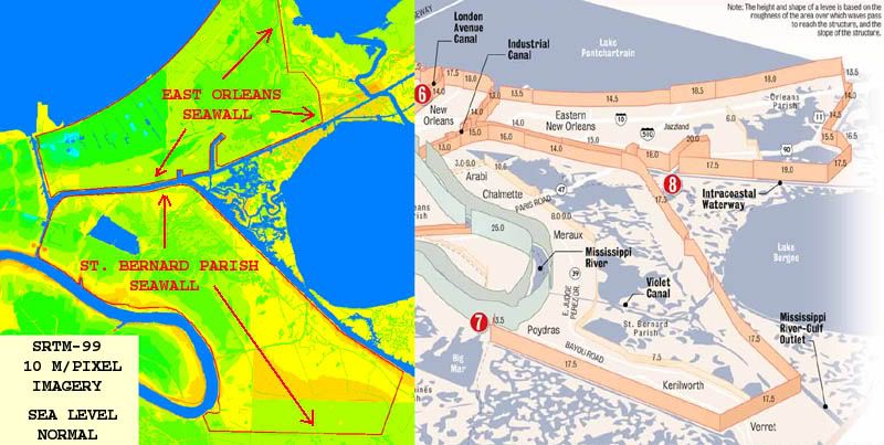
The image above shows elevation data for St. Bernards Parish as of 1999, using mapping software calibrated to a normal sea level. Relevent levee systems are artificially highlighted in red.
In the next image below, sea level has been digitally increased to six feet above normal.
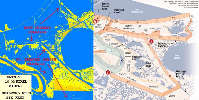
In the above image, nearly all major sections of the levee/seawalls are still visible, as they should be if they are indeed 17 feet above sea level. However, the following two images clearly show that at sea levels of eight feet above normal, large sections of the St. Bernards Parish seawall/levee system are no longer visible.
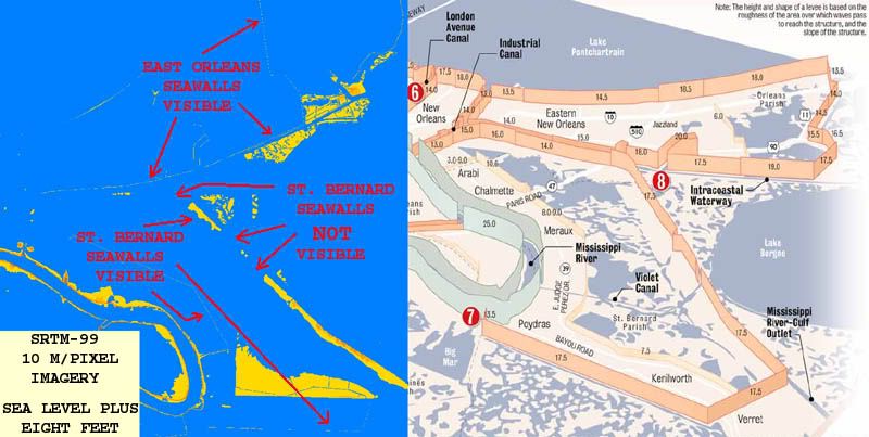
Note missing levee sections above.
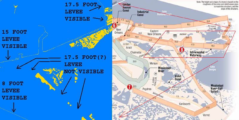
A closer view of selected portions of image three.
These disturbing images leave no choice but to raise the following questions:
1. How often were these sections of the levee seawall system inspected?
2. Have they been inspected since 1999?
3. What method(s) were used during post 1999 levee inspections to determine the actual height of these structures? GPS? Laser level circuit from a known and tested benchmark? Optical transit or dumpy level circuit from a known and tested benchmark? Eyeball estimate?
4. Were these inspections carried out on the ground or by aerial survey?
5. Were any discrepancies noted during these assumed inspections?
6. What actions were taken to remedy any problems found during these inspections?
7. If it was found that subsidence had indeed lowered the seawall/levee structures, who was informed of these discrepancies, and when were they made aware of them?
8. If no discrepancies were noted, then why do high resolution shuttle radar images clearly show seawalls measured at 8, 15, and 17.5 feet, while not showing seawalls which supposedly top out at 17 feet in other nearby locations?
Given that St. Bernards Parish was the first area to flood during Hurricane Katrina, and that this area will likely yield the highest body count, these are questions that demand answers.
It is no secret that the missing levee sections noted in the above imagery include those areas most likely to fail in the event a storm surge is funneled from Lake Borgne into the Intercoastal Waterway. If these sections had already subsided and sank as far back as 1999, and local and state officials cannot document repairs since then, at the very least the public has been falsely assured, and by the reckoning of some, charges of negligence or even malicious negligence may not be out of order.
TOPICS: Crime/Corruption; Culture/Society; Government; Miscellaneous; News/Current Events; Technical; US: Louisiana; Your Opinion/Questions
KEYWORDS: failure; flood; hurricane; katrina; levee; neworleans; shuttle; space; surge
Navigation: use the links below to view more comments.
first 1-20, 21-40, 41-46 next last
1
posted on
09/14/2005 4:39:54 PM PDT
by
jeffers
To: jeffers
Which one is the levee that Rove dynamited?
/sar.
2
posted on
09/14/2005 4:43:08 PM PDT
by
frankjr
To: jeffers
I don't know. I think Blanco and the media have already assigned blame for the levies on the administration and the Corps. Any further blame will still be shifted that way.
3
posted on
09/14/2005 4:47:50 PM PDT
by
satchmodog9
(Murder and weather are our only news)
To: jeffers
Good questions.
They deserve answers.
4
posted on
09/14/2005 4:49:56 PM PDT
by
okie01
(The Mainstream Media: IGNORANCE ON PARADE)
To: jeffers; jan in Colorado; Former Dodger; Dark Skies; USF
the wonders of modern technology...Blanko lied as NO sank.
5
posted on
09/14/2005 4:54:41 PM PDT
by
Fred Nerks
(Understand islam understand evil - read THE LIFE OF MUHAMMAD free pdf see link My Page)
To: jeffers
6
posted on
09/14/2005 4:55:03 PM PDT
by
jra
To: jeffers
You've posed some interesting questions. She certainly did everything in her power to keep people, people who could have provided relief and saved lives, out of New Orleans. It was a Herculean effort on her behalf.
7
posted on
09/14/2005 4:58:03 PM PDT
by
Peach
(South Carolina is praying for our Gulf coast citizens.)
To: satchmodog9
satchmodog9 wrote:
" don't know. I think Blanco and the media have already assigned blame for the levies on the
administration and the Corps. Any further blame will still be shifted that way."
Blanco's a state governor.
She's not the Speaker of the House, nor the Senate Majority Leader, nor does her party control either house.
The facts will be heard.
8
posted on
09/14/2005 4:58:39 PM PDT
by
jeffers
To: jeffers
Good report, Jeffers... now to get someone to ask the same questions.
To: jeffers
Interesting data. If it helps any, I remember before the storm there were many experts interviewed about the seawall levee system. Many said that some of the seawalls had sunken, and their original heights were no longer reliable measures of protection.
10
posted on
09/14/2005 5:03:35 PM PDT
by
Semper911
(Nagin = Mayor Culpa)
To: OXENinFLA
To: Semper911
Semper911 wrote:
"Interesting data. If it helps any, I remember before the storm there were many experts interviewed about
the seawall levee system. Many said that some of the seawalls had sunken, and their original heights were
no longer reliable measures of protection."
My software shows levees that are supposed to be 17 feet tall, being as low as 6.6 feet above sea level in some of the areas I noted.
You can't even miss that much subsidence from the air or hiking along the tops.
Binary solution set.
NASA screwed the pooch, or else somebody was asleep at the switch.
For a minimum of six years.
12
posted on
09/14/2005 5:13:28 PM PDT
by
jeffers
To: Arizona Carolyn
Arizona Carolyn wrote:
"Good report, Jeffers... now to get someone to ask the same questions."
I can't do much for the TP article, or the levee map from the same source, but as for my work, consider it public domain.
Ping your friends, tell them to ping theirs, ping the media, run with it.
Some folks down south need a wake-up call.
13
posted on
09/14/2005 5:16:29 PM PDT
by
jeffers
To: jeffers
NASA screwed the pooch, or else somebody was asleep at the switch.Yeah, I see what you mean. I was just recalling those talking heads saying that they were supposed to be 17 feet high, but that there had been settlement and they were no longer that high.
You would know better than I how long it takes for a seawall to "settle" more than 10 feet.
14
posted on
09/14/2005 5:19:28 PM PDT
by
Semper911
(Nagin = Mayor Culpa)
To: jeffers
How about a little primer on how the politics work as far as maintaining the levees. Is it a state responsibility to inform the Corps of Engineers of these problems? My initial impression is that it's a Corps function and any blame for not reporting the poor state of these levees would fall to them.
I'm looking forward to you disabusing me of that notion.
15
posted on
09/14/2005 5:25:22 PM PDT
by
Arkie2
(Mega super duper moose, whine, cheese, series, zot, viking kitties, barf alert!)
To: jeffers
16
posted on
09/14/2005 5:30:04 PM PDT
by
rellimpank
(urbanites don' t understand the cultural deprivation of not being raised on a farm:NRABenefactor)
To: jeffers
It's too bad this thread died. i think you're on to something.
17
posted on
09/14/2005 6:09:03 PM PDT
by
Arkie2
(Mega super duper moose, whine, cheese, series, zot, viking kitties, barf alert!)
To: Fred Nerks; jeffers; fastattacksailor; swordfish71; broadsword; Nesher; ariamne; ...
Another great catch, Fred, Thanks for the PING!
Great post, Jeffers.
The Disappearing Levee PING!
18
posted on
09/14/2005 6:14:50 PM PDT
by
Former Dodger
( "Insanity: Doing the same thing over and over again and expecting different results." --Einstein)
To: jeffers
Technical question from a rank amateur:
I have read that parts of the levee are 100% earthworks, while other parts have lower earthworks with a concrete wall at the peak.
Given the resolution of the photos, would a much thinner concrete wall show up, or would it disappear because it's so much thinner than earthworks?
Do the areas with concrete tops correspond to the missing areas on the map?
19
posted on
09/14/2005 6:15:43 PM PDT
by
ZOOKER
( <== I'm with Stupid...)
To: jeffers
Digital Elevation Models (DEMs) BUMP.
20
posted on
09/14/2005 6:23:11 PM PDT
by
hummingbird
(21st Century Newsreporting - "Don't get me started!")
Navigation: use the links below to view more comments.
first 1-20, 21-40, 41-46 next last
Disclaimer:
Opinions posted on Free Republic are those of the individual
posters and do not necessarily represent the opinion of Free Republic or its
management. All materials posted herein are protected by copyright law and the
exemption for fair use of copyrighted works.
FreeRepublic.com is powered by software copyright 2000-2008 John Robinson