| This thread has been locked, it will not receive new replies. |
|
Locked on 08/28/2005 9:46:32 AM PDT by Admin Moderator, reason:
Locked - New Thread http://www.freerepublic.com/focus/news/1472323/posts |
Posted on 08/27/2005 8:05:55 PM PDT by NautiNurse
Hurricane warnings and watches are posted. Hurricane Katrina continues to strengthen in the Gulf of Mexico. The forecast models continue to converge upon New Orleans. However, all interests in the northern Gulf of Mexico should follow the path of this very large and dangerous storm, and be prepared for a major hurricane landfall. There have been reports of coastal animals leaving in droves for higher ground. Meanwhile, New Orleans continues to suggest that residents evacuate.
The following links are self-updating:
Public Advisory Currently published every 3 hours 5A, 8A, 11A, 2P, etc. ET
NHC Discussion Published every six hours 6A, 11A, 6P, 11P
Three Day Forecast Track
Five Day Forecast Track
Navy Storm Track
Katrina Track Forecast Archive Nice loop of each NHC forecast track for both three and five day
Forecast Models
Alternate Hurricane Models via Skeetobite
Bouy Data Louisiana/Mississippi
Buoy Data Florida
Images:
New Orleans/Baton Rouge Experimental Radar Subject to delays and outages - and well worth the wait
Ft. Polk, LA Long Range Radar Loop
Northwest Florida Long Range Radar
Storm Floater IR Loop
Storm Floater Still & Loop Options
Color Enhanced IR Loop
Other Resources:
Hurricane Wind Risk Very informative tables showing inland wind potential by hurricane strength and forward motion
Central Florida Hurricane Center
New Orleans Web Cams Loads of web cam sites here. The sites have been very slow due to high traffic
New Orleans Music Online Couldn't resist--love that jazz
Golden Triangle Weather Page Nice Beaumont weather site with lots of tracks and graphics
Hurricane City
Crown Weather Tropical Website Offers a variety of storm info, with some nice track graphics
Live streaming:
copy/paste into player:
WWL-TV/DT New Orleans (WMP) - mms://beloint.wm.llnwd.net/beloint_wwltv
WVTM-TV/DT Birmingham (WMP) - mms://a1256.l1289835255.c12898.g.lm.akamaistream.net/D/1256/12898/v0001/reflector:35255
WDSU-TV/DT New Orleans (WMP) - http://mfile.akamai.com/12912/live/reflector:38202.asx
Hurricane City (Real Player) - http://hurricanecity.com/live.ram
ABCNews Now (Real Player) - http://reallive.stream.aol.com/ramgen/redundant/abc/now_hi.rm
Hurricane Katrina Live Thread, Part III
Katrina Live Thread, Part II
Hurricane Katrina Live Thread, Part I
Tropical Storm 12
| Category | Wind Speed | Barometric Pressure | Storm Surge | Damage Potential |
|---|---|---|---|---|
| Tropical Depression |
< 39 mph < 34 kts |
Minimal | ||
| Tropical Storm |
39 - 73 mph 34 - 63 kts |
Minimal | ||
| Hurricane 1 (Weak) |
74 - 95 mph 64 - 82 kts |
28.94" or more 980.02 mb or more |
4.0' - 5.0' 1.2 m - 1.5 m |
Minimal damage to vegetation |
| Hurricane 2 (Moderate) |
96 - 110 mph 83 - 95 kts |
28.50" - 28.93" 965.12 mb - 979.68 mb |
6.0' - 8.0' 1.8 m - 2.4 m |
Moderate damage to houses |
| Hurricane 3 (Strong) |
111 - 130 mph 96 - 112 kts |
27.91" - 28.49" 945.14 mb - 964.78 mb |
9.0' - 12.0' 2.7 m - 3.7 m |
Extensive damage to small buildings |
| Hurricane 4 (Very strong) |
131 - 155 mph 113 - 135 kts |
27.17" - 27.90" 920.08 mb - 944.80 mb |
13.0' - 18.0' 3.9 m - 5.5 m |
Extreme structural damage |
| Hurricane 5 (Devastating) |
Greater than 155 mph Greater than 135 kts |
Less than 27.17" Less than 920.08 mb |
Greater than 18.0' Greater than 5.5m |
Catastrophic building failures possible |
I am afraid this is going to be a huge disaster. Prayers for all in its path.
I share your concern.
This is a very frightening storm.
Couple of new images of Katrina
http://www5.wright-weather.com/bb/showthread.php?s=&postid=452165#post452165
Either that or they are scared slap silly.
btw/I adore Jane. Both of her; Margaret Rutherford and Geraldine McEwan ;)
Do you know when the next update is?
I'm wondering if she might not turn at all. She seems to be modifying the environment around her to suit where she wants to go.
000
wtnt32 knhc 280850
tcpat2
bulletin
hurricane katrina advisory number 21
nws tpc/national hurricane center miami fl
4 am cdt sun aug 28 2005
...dangerous category four hurricane katrina continues
west-northwestward but expected to turn northward...
...new tropical storm warnings issued for northern gulf coast...
a hurricane warning is in effect for the north central gulf coast
from morgan city louisiana eastward to the alabama/florida
border...including the city of new orleans and lake pontchartrain.
a hurricane warning means that hurricane conditions are expected
within the warning area within the next 24 hours. preparations to
protect life and property should be rushed to completion.
a tropical storm warning and a hurricane watch are in effect from
east of the alabama/florida border to destin florida...and from
west of morgan city to intracoastal city louisiana. a tropical
storm warning means that tropical storm conditions are expected
within the warning area within the next 24 hours. a hurricane watch
means that hurricane conditions are possible within the watch
area...generally within 36 hours.
at 4 am cdt...0900z...a tropical storm warning has been issued from
destin florida eastward to indian pass florida...and from
intracoastal city louisiana westward to cameron louisiana.
a tropical storm warning means that tropical storm conditions are
expected within the warning area within the next 24 hours.
for storm information specific to your area...including possible
inland watches and warnings...please monitor products issued
by your local weather office.
at 4 am cdt...0900z...the center of hurricane katrina was located
near latitude 25.4 north... longitude 87.4 west or about 275 miles
south-southeast of the mouth of the mississippi river.
katrina is moving toward the west-northwest near 10 mph. a gradual
turn toward the northwest is expected later today.
maximum sustained winds are near 145 mph with higher gusts. katrina
is a category four hurricane on the saffir-simpson scale. some
strengthening is forecast during the next 24 hours.
hurricane force winds extend outward up to 85 miles from the
center...and tropical storm force winds extend outward up
to 185 miles.
estimated minimum central pressure is 935 mb...27.61 inches.
coastal storm surge flooding of 15 to 20 feet above normal tide
levels...locally as high as 25 feet along with large and dangerous
battering waves...can be expected near and to the east of where the
center makes landfall.
rainfall totals of 5 to 10 inches...with isolated maximum amounts of
15 inches...are possible along the path of katrina across the gulf
coast and the southeastern united states. the hurricane is still
expected to produce additional rainfall amounts of 2 to 4 inches
over extreme western cuba...and 1 to 3 inches of rainfall is
expected over the yucatan peninsula.
isolated tornadoes will be possible beginning sunday evening over
southern portions of louisiana...mississippi...and alabama...and
over the florida panhandle.
repeating the 4 am cdt position...25.4 n... 87.4 w. movement
toward...west-northwest near 10 mph. maximum sustained
winds...145 mph. minimum central pressure... 935 mb.
an intermediate advisory will be issued by the national hurricane
center at 7 am cdt followed by the next complete advisory at 10 am
cdt.
forecaster knabb
You're right. I was watching. They act like they're talking about a morning shower. It's very wrong. The Weather Channel is not what it used to be.
But on the better side, I saw that FoxNews had Amy Kellogg in the studio last night doing a show. She earned it, she's great.
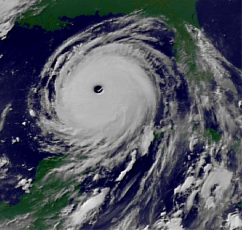
How wide is that eye now ............... 60 miles?
7 am CDT, I think.
There are no other strong influences on it and it's traveling over warmer and warmer wayer.
"They can evacuate to the dome.........."
With the huge population of violent criminals in New Orleans, it may be more dangerous in the dome than outside of it.
I have an uncle that lives 6-10 feet below flood stage of one of the rivers near Houston. There is a levee system on that river..
Perhaps the hurricane evacuees could go to camp Casey to visit Cindy....
That seems newsworthy-two stories in one!
New Orleans TV interviewed the Mayor earlier. He said that "the Dome is the shelter of last resort."
Live broadcast:
http://www.wwltv.com/perl/common/video/wmPlayer.pl?title=beloint_wwltv&props=livenoad
Unreal (unbelievable)
For some reason I was under the impression the deep ditches found in and around Houston were dug for flood control. I know we had a very deep ditch near our subdivision that usually was either dry or had a very small stream. (easily jumped across by a 10 year old)
She is one big ugly broad. Daytime is going to be bad enough, I wouldn't want to meet up with her in the dark.
Prayers up for all in the path of the terrible storm.
Disclaimer: Opinions posted on Free Republic are those of the individual posters and do not necessarily represent the opinion of Free Republic or its management. All materials posted herein are protected by copyright law and the exemption for fair use of copyrighted works.