| This thread has been locked, it will not receive new replies. |
|
Locked on 08/28/2005 9:46:32 AM PDT by Admin Moderator, reason:
Locked - New Thread http://www.freerepublic.com/focus/news/1472323/posts |
Posted on 08/27/2005 8:05:55 PM PDT by NautiNurse
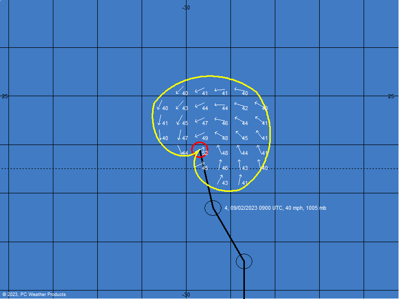
Hurricane warnings and watches are posted. Hurricane Katrina continues to strengthen in the Gulf of Mexico. The forecast models continue to converge upon New Orleans. However, all interests in the northern Gulf of Mexico should follow the path of this very large and dangerous storm, and be prepared for a major hurricane landfall. There have been reports of coastal animals leaving in droves for higher ground. Meanwhile, New Orleans continues to suggest that residents evacuate.
The following links are self-updating:
Public Advisory Currently published every 3 hours 5A, 8A, 11A, 2P, etc. ET
NHC Discussion Published every six hours 6A, 11A, 6P, 11P
Three Day Forecast Track
Five Day Forecast Track
Navy Storm Track
Katrina Track Forecast Archive Nice loop of each NHC forecast track for both three and five day
Forecast Models
Alternate Hurricane Models via Skeetobite
Bouy Data Louisiana/Mississippi
Buoy Data Florida
Images:
New Orleans/Baton Rouge Experimental Radar Subject to delays and outages - and well worth the wait
Ft. Polk, LA Long Range Radar Loop
Northwest Florida Long Range Radar
Storm Floater IR Loop
Storm Floater Still & Loop Options
Color Enhanced IR Loop
Other Resources:
Hurricane Wind Risk Very informative tables showing inland wind potential by hurricane strength and forward motion
Central Florida Hurricane Center
New Orleans Web Cams Loads of web cam sites here. The sites have been very slow due to high traffic
New Orleans Music Online Couldn't resist--love that jazz
Golden Triangle Weather Page Nice Beaumont weather site with lots of tracks and graphics
Hurricane City
Crown Weather Tropical Website Offers a variety of storm info, with some nice track graphics
Live streaming:
copy/paste into player:
WWL-TV/DT New Orleans (WMP) - mms://beloint.wm.llnwd.net/beloint_wwltv
WVTM-TV/DT Birmingham (WMP) - mms://a1256.l1289835255.c12898.g.lm.akamaistream.net/D/1256/12898/v0001/reflector:35255
WDSU-TV/DT New Orleans (WMP) - http://mfile.akamai.com/12912/live/reflector:38202.asx
Hurricane City (Real Player) - http://hurricanecity.com/live.ram
ABCNews Now (Real Player) - http://reallive.stream.aol.com/ramgen/redundant/abc/now_hi.rm
Hurricane Katrina Live Thread, Part III
Katrina Live Thread, Part II
Hurricane Katrina Live Thread, Part I
Tropical Storm 12
| Category | Wind Speed | Barometric Pressure | Storm Surge | Damage Potential |
|---|---|---|---|---|
| Tropical Depression |
< 39 mph < 34 kts |
Minimal | ||
| Tropical Storm |
39 - 73 mph 34 - 63 kts |
Minimal | ||
| Hurricane 1 (Weak) |
74 - 95 mph 64 - 82 kts |
28.94" or more 980.02 mb or more |
4.0' - 5.0' 1.2 m - 1.5 m |
Minimal damage to vegetation |
| Hurricane 2 (Moderate) |
96 - 110 mph 83 - 95 kts |
28.50" - 28.93" 965.12 mb - 979.68 mb |
6.0' - 8.0' 1.8 m - 2.4 m |
Moderate damage to houses |
| Hurricane 3 (Strong) |
111 - 130 mph 96 - 112 kts |
27.91" - 28.49" 945.14 mb - 964.78 mb |
9.0' - 12.0' 2.7 m - 3.7 m |
Extensive damage to small buildings |
| Hurricane 4 (Very strong) |
131 - 155 mph 113 - 135 kts |
27.17" - 27.90" 920.08 mb - 944.80 mb |
13.0' - 18.0' 3.9 m - 5.5 m |
Extreme structural damage |
| Hurricane 5 (Devastating) |
Greater than 155 mph Greater than 135 kts |
Less than 27.17" Less than 920.08 mb |
Greater than 18.0' Greater than 5.5m |
Catastrophic building failures possible |
According to the Mayor and the weatherman on WWL-TV, the levees were only 15 feet high when they were built, and have since settled to about 13 ft high. And they're just earthen levees. Debris - boats, pieces of structures - carried by the storm surge and waves will just punch holes into the levees. The city pumps water out to Lake Pontchartrain, but the hurricane winds will force water from the lake back into the city.
From http://www.weather.com/newscenter/specialreports/hurricanes/vulnerablecities/neworleans.html
"The levees that protect the city from flooding are also a flood threat themselves. "The biggest threat that the city has is that of a slow moving Category 3, 4 or 5 hurricane, which would create a surge of water that could be up to 30 feet high. Now if this (high) water comes into the city, it will top the levees. It will go over the top of the levees and actually fill up the city," "
Heh. People shouldn't be surprised why the mayor is hesitant then.
Speaking of God..Loyola University is right in harms way as well. I'd be in a state of panic if my child was there.
sw
The size of this storm will leave a swath of destruction that is difficult to grasp.
Glad to know when we can have public prayer...
Only when a category 5 hurricane is going to hit your city.
I couldn't leave someone behind like that :(
AP has just ordered all their reporters in NO to evacuate...


agreed.
and Tulane University
I couldn't either. I'd cram her in somewhere.
Forget the levees, at this rate of intensification the Superdome is in jeopardy. If not from the storm then from the tornados.
I wouldn't want to be stuck in there for weeks even if it holds up structurally
do you have an online link for the radio station? thanks.
Radio station in NOLA just called for listeners to pray ...
Hope they have stronger wind anemometers then they did inf Florida.
I have been in the eye of a cat 3 hurricane. It is like being in the rage of God. And that one was a minimum cat 3 at that.
Disclaimer: Opinions posted on Free Republic are those of the individual posters and do not necessarily represent the opinion of Free Republic or its management. All materials posted herein are protected by copyright law and the exemption for fair use of copyrighted works.