
Posted on 07/13/2005 7:11:21 PM PDT by NautiNurse
Hurricane Emily resources--the links are self-updating for handy reference:
NHC Hurricane Public Advisory Updates Currently published every three hours 5A, 8A, 11A, 2P, etc. ET.
NHC Hurricane Discussion Updates Published every 6 hours 5A, 11A, 5P, 11P ET
Caribbean Visible Loop (Only works during daylight hours)
Puerto Rico Long Range Radar Loop
Emily Forecast Track Archive Loop Great for reviewing the 3 day and 5 day historic track positions
Alicia taught me that there is no such thing as wind resistant mobile homes.
re 281 things are starting to get interesting, let a shimper borrow my generator, time to get it back.
low presure setting up in central texas, if that stays for a few days watch out.
Things are beginning to get interesting...
But the computer models are merely slight variations of the extrapolation of her current forward motion.
It's a 100% certainty that Cancun and Cozumel will have a lousy start to the week no matter what.
Unless the models eventually show a weakening of the ridge and a northward turn, a kid could predict landfall with a ruler.

The only people who live where it came ashore are cows, unless you count the illigal immigrants who don't really live there but are hoofing it up toward Corpus Christi and Houston and happened to be in the wrong place at the wrong time.
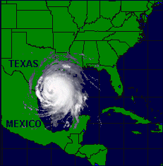
This is still the largest hurricane of record to hit Texas and covered the entire Gulf of Mexico. For 3 days (9/10-9/12) it hung off theTexas coast between Corpus Christi and Port Author with eye winds varying between 125 and 175 mph. I lived in Corpus Christi, three blocks from the bay, and we didn't dare go outside until the 4th day since hurricane force winds extended along the coast. It went into Port Lavaca with 175 mph winds. SCUBA MOM
Hurricane Carla
September 9-12, 1961
The most powerful tropical system to affect the Texas coast in over 40 years…Hurricane Carla made landfall between Port O’Connor and Port Lavaca on the day of September 11, 1961. In the open waters of the Gulf, a minimum central pressure of 931mb, or 27.50 inches along with maximum sustained wind speeds over 150 mph, made Carla a category 5 hurricane on the Saffir-Simpson scale of hurricane intensity. When the "eye" or center of Hurricane Carla made landfall early in the morning of the 11th, the intensity had dropped off but the storm was still packing winds of 120 mph in areas from Port O’Connor up the coast to Galveston. The "eye" of the storm came within 65 miles to the east of Corpus Christi.
Hurricane warnings were issued along the entire Texas coast on the 9th prompting immediate evacuation of all islands just offshore and low coastal areas. The wind, not the rain, became the major weather factor for the Coastal Bend area. Preliminary wind reports from locations hit hardest by Carla indicated sustained wind speeds of 115 mph in Matagorda…110 mph in Victoria…and 88 mph in Galveston. Peak wind gusts were estimated at 150 mph in Victoria and 170 mph at Port Lavaca! Average wind gusts of 80 to 90 mph were reported across Corpus Christi, with a peak wind of 81 mph recorded at the tower of the Weather Bureau Office, before failure of the instrument.
Rainfall amounts were heaviest from Port Lavaca up the coast to Galveston and within 50 miles inland, ranging from 10 to 16 inches in some spots. Galveston Airport recorded 16.49" of rain in a four-day period. Closer to home, at the airport in Corpus Christi, a relatively light 1.22" fell, but downtown Corpus had 5.15". Victoria recorded a notable 6.25" of rain.
Lowest central pressure recorded at the Corpus airport was 28.88" and at the navy base, 28.73". As the center of the storm passed over Port Lavaca, a calibrated barometer positioned at a dredging company recorded the lowest pressure anywhere on land, with 27.62" before the needle dipped below the reported scale.
With the intense wind, storm surge became a major problem. In some areas from Port Aransas to Sabine Pass, tides were 10 feet above normal…the highest levels since the storm of 1919. One report out of Port Lavaca had a tide level 18.5 feet above normal. The above normal tides produced extensive beach and inland damage to houses and businesses. Over the Corpus Christi area, most of the damage was to roofs, power and telephone lines, trees, and signs. One exception, were low-lying areas, which became flooded from heavy rain and caused more extensive damage. Estimated damage costs exceeded $300 million in Texas, with property losses being the primary contributor. In Nueces County alone, over $12 million in damage was reported from a combination of property damage and severe crop losses.
When it was all said and done, 43 people lost their lives to Hurricane Carla…31 known in the state of Texas.
You got that right...if there's any location that could ever be perfect for a hurricane landing...its definitely the KING RANCH...
I had never heard the snow-hurricane folklore either but in a way it makes sense. I think it's just saying that in a year with extreme weather, there tends to be more extreme weather. More volatility, in other words. Lots of things in nature have quiescent periods and other periods with more variability. In fact, even the stock market acts that way (VIX and VXN are used as measures of volatility).
Thanks for that wind correction. Carla was huge in size....I didn't think the winds were as high as Scuba Mom said...but the picture said a lot. Carla did lots of destruction...my grandparents lived in that area and couldn't return for weeks and weeks.
People arount here still talk about Carla as the Big One.
Looks like we're due...worrying these days ;o(
Pressure 958mb
Only a day ago, some believed it would grind ashore Venezuela and break up.
What a difference a day makes.
Nice radar find.
...Major Hurricane Emily gains more strength...
At 11 PM AST...0300z...the government of the Cayman Islands has
issued a Hurricane Watch for all of the Cayman Islands.
A Hurricane Watch is now in effect for Jamaica and for all of the
Cayman Islands.
At 11 PM AST...the government of Venezuela has discontinued the
Tropical Storm Warning east of Caracas.  A Tropical Storm Warning
remains in effect for the northern coast of Venezuela from Caracas
westward to punto fijo...including the offshore islands north of
the coast and west of Caracas.
A Tropical Storm Warning is also in effect for portions of the
southern coast of the Dominican Republic from Punta Salinas
westward to the Dominican Republic/Haiti border...and for the
entire southwestern peninsula of Haiti from the Dominican
Republic/Haiti border to Port-au-Prince.
A Tropical Storm Warning is also in effect for Bonaire... Curacao...
and Aruba.
Interests elsewhere in the central and western Caribbean should
monitor the progress of Emily.
For storm information specific to your area...including possible
inland watches and warnings...please monitor products issued
by your local weather office.
At 11 PM AST...0300z...the center of Hurricane Emily was located
near latitude 13.6 north... longitude 67.5 west or about 375
miles... 600 km... south-southeast of Santo Domingo in the
Dominican Republic and about 690 miles...1110 km...east-southeast
of Kingston Jamaica.
Emily is moving toward the west-northwest near 20 mph
...32 km/hr...and this motion is expected to continue during the
next 24 hours.
Data from a United States Air Force reconnaissance aircraft indicate
that maximum sustained winds have increased and are now near 125
mph...205 km/hr...with higher gusts.  Emily is a category three
hurricane on the Saffir-Simpson scale.  Some additional
strengthening is possible...and Emily could become a category four
hurricane during the next 24 hours.
Hurricane force winds extend outward up to  25 miles... 35 km...
from the center...and tropical storm force winds extend outward up
to 125 miles...205 km.
Reports from the reconnaissance aircraft indicate that the minimum
central pressure in Emily has been falling during the past few
hours.  Based on these reports...the estimated minimum central
pressure is 957 mb...28.26 inches.
Emily is expected to produce total rainfall accumulations of 2 to 4
inches across portions of the Netherlands Antilles.  Rainfall totals
of 3 to 6 inches are expected over portions of Hispaniola...with
isolated 8 inch amounts possible.  These rains could produce
life-threatening flash floods and mud slides.
Repeating the 11 PM AST position...13.6 N... 67.5 W.  Movement
toward...west-northwest near 20 mph.  Maximum sustained
winds...125 mph.  Minimum central pressure... 957 mb.
An intermediate advisory will be issued by the National Hurricane
Center at 2 am AST followed by the next complete advisory at 5 am
AST.
Forecaster Knabb
Disclaimer: Opinions posted on Free Republic are those of the individual posters and do not necessarily represent the opinion of Free Republic or its management. All materials posted herein are protected by copyright law and the exemption for fair use of copyrighted works.