Skip to comments.
The Wana Campaign -- Maps, Place Names and Participants
An FReference Thread
Boot Hill
| March 21, 2004
| Boot Hill
Posted on 03/21/2004 3:34:25 AM PST by Boot Hill
The Wana Campaign -- Maps, Place Names and Participants
An FReference Thread
[This thread was designed primarily as a reference tool. Please limit posts to necessary additions, corrections, questions and pings. Thank you.]
This thread is a reference source of basic information on the Wana (Pakistan) anti-terrorist campaign. It inlcudes maps, locations of geographic place names, ethnic, religious and population information that can benefit the FReeper trying to get a handle on what's happening in this major battle of the War on Terror.
Map #1, Pakistan
As can be seen on the map below, Pakistan is comprised of 4 provinces and one Federally Administered Tribal Areas (or FATA). The Wana campaign is being fought in these tribal areas. The tribal areas can be found on the map about 1/3 of the way down and 1/2 way across, along the border with Afghanistan.
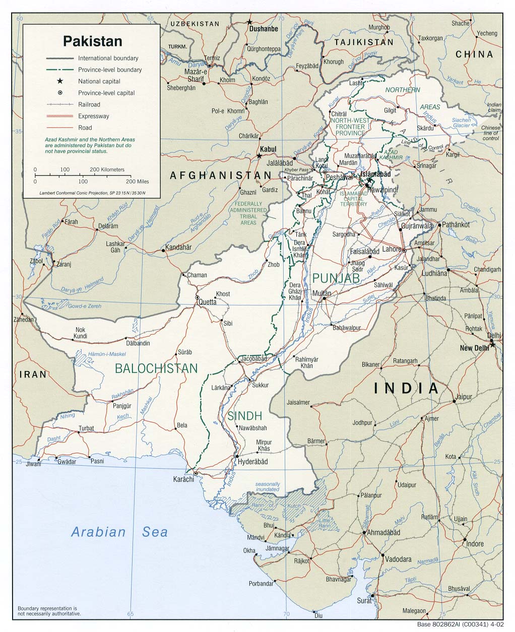
Map #2, The Federally Administered Tribal Areas (in gray)
FATA is comprised of seven distinct agencies. The current campaign is being conducted in the South Waziristan Agency, and more specifically, in the area surrounding the capitol city of Wana. (see below)

Map #3, Waziristan (not labeled), but centered about the capitol of Wana

Map #4, Wana (center) and surrounding area, higher resolution

Map #5, Wana (center) and surrounding area, highest resolution

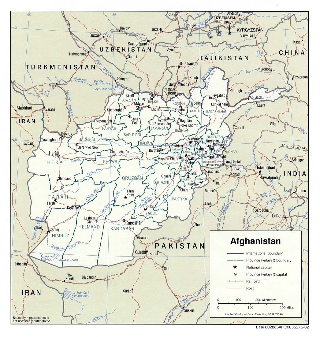
Finally...If you need a map of Afghanistan (including the provinces) the following link will open in a new window.
Map of Afghanistan
IMPORTANT PLACE NAMES OF THE WANA COMBAT AREA
|
|
| VARIANT |
NATIVE |
CNTRY |
ON MAP? |
LOCATION |
SOURCE |
|
|
| Azam Warsak |
Azamiwarsakai |
PK |
NO |
27 km (17 miles) SSW (213°) of Wana |
GEONames |
|
|
| Shin Warsak |
Shin Warsak Sat |
PK |
NO |
6 km (3 miles) WWS (239°) of Wana |
GEONames |
|
|
| Kaloosha |
Kalosha |
PK |
NO |
11 km (7 miles) W (264°) of Wana |
GEONames |
|
|
| Zarian Noor |
|
PK |
NO |
"within 15 km of Azam Warsak" |
News Reports |
|
|
| Shakin [1] |
Shkin |
AF |
YES |
37 km (23 miles) NW (311°) of Wana |
GEONames |
|
|
| Angorada [2] |
De Angur Kot Zyabu |
AF/PK |
NO |
6 km (4 miles) NE (37°) of Shkin |
GEONames |
|
|
| Lwara [3] |
Lwara Dasta |
AF |
NO |
74 km (46 miles) N (353°) of Wana |
GEONames |
|
|
NOTES:
1. Shkin: This is the sight of a major U.S. forward fire base. Shkin is known amongst U.S. troops as "the most evil place in Afghanistan". This base has been the sight of bloody fighting since early 2002.
2. Angorada: This village belonged to Afghanistan till April,1992, but was annexed by Pakistan thereafter. That annexation is still in dispute and has been the cause for claims of cross-border incurrsions by both sides. Notice the proximity to Shkin. Angorada has over 13 spelling variations that I'm aware of.
3. Lwara: This is the Lwara located in Paktika Province (Afghanistan), ajacent to Waziristan (Pakistan). There is another Lwara in Paktia Province, near Khowst (to the north). Both are U.S. forward fire bases on the Afghani/Paki frontier.
SOURCES:
GEONames data base
University of Texas Map Collection
MultiMap.com
TOPICS: Foreign Affairs; News/Current Events; War on Terror; Your Opinion/Questions
KEYWORDS: manhunt; maps; pakistan; southasia; wana; waronterror; waziristan
Navigation: use the links below to view more comments.
first 1-20, 21-36 next last
1
posted on
03/21/2004 3:34:26 AM PST
by
Boot Hill
To: Cap Huff; Dog; Coop; swarthyguy; Angelus Errare; Ernest_at_the_Beach; Prodigal Son
FYI
If anyone has a more inclusive ping list, would you mind pinging it?
--Boot Hill
2
posted on
03/21/2004 3:36:40 AM PST
by
Boot Hill
(Candy-gram for Osama bin Mongo, candy-gram for Osama bin Mongo!)
To: Boot Hill
Thanks for the info.
3
posted on
03/21/2004 6:32:46 AM PST
by
expatpat
To: Boot Hill
Thanks Boot.
4
posted on
03/21/2004 10:14:33 AM PST
by
Dog
To: Boot Hill; blam; Ragtime Cowgirl; Ranger
Terrific work. Finally found
Shkin!Why does the map show the important names in the smallest type? (That's on the last two maps with the yellow lines)
Are those expressways?
Or Donkey trails?
5
posted on
03/21/2004 11:44:25 AM PST
by
Ernest_at_the_Beach
(The terrorists and their supporters declared war on the United States - and war is what they got!!!!)
To: Boot Hill; Khan Noonian Singh; Valin; Grampa Dave; LibWhacker; Lion in Winter
Boot Hill,
Thanks for compiling this thread.
6
posted on
03/21/2004 11:51:36 AM PST
by
Cap Huff
To: Boot Hill; Ernest_at_the_Beach; MJY1288; xzins; Calpernia; TEXOKIE; Alamo-Girl; windchime; ...
This is the sight of a major U.S. forward fire base. Shkin is known amongst U.S. troops as "the most evil place in Afghanistan". This base has been the sight of bloody fighting since early 2002. ~~~~~~~~~~~~~~~~~~~~~~~~~~~~~
FYI, w/ maps!
Thanks, Boot Hill.
Thanks for the ping, Ernest. (^:
7
posted on
03/21/2004 1:37:12 PM PST
by
Ragtime Cowgirl
("(We)..come to rout out tyranny from its nest. Confusion to the enemy." - B. Taylor, US Marine)
To: Boot Hill
From another fr thread
In fact, the fighting that continued into Sunday is concentrated in about a 30 square mile area near the city of Wana, around the villages of Shin Warsak, Daza Gundai, Kallu Shah, Ghaw Khawa, and Khari Kot.
8
posted on
03/21/2004 2:10:40 PM PST
by
Capt. Tom
(Don't confuse the Bushies with the dumb republicans. - Capt. Tom)
To: Cap Huff; Dog; Coop; swarthyguy; Angelus Errare; Ernest_at_the_Beach; Prodigal Son
update...WHY THE WANA AREA?
Much has been made of the fact that the Pakistani tribal areas are desolate, mountainous areas peopled by fierce warlords. But the reasons for al-Qa'ida and the Taliban hiding out there is much more complex than that.
In 1893, Sir Henry Mortimer Durand, the foreign secretary of British India (which included Pakistan) completed a treaty with the Amir Abdul Rahman Khan of Afghanistan to establish what is known today as the "Durand Line" as being the official boundary between Afghanistan and Pakistan. The surveying and mapping that produced that line, was based more on geography and British wishful thinking, than on problems of regional ethnicity. And therein lies the seeds of the current situation today.
To understand the crux of the problem, look at this Map of ethnic distribution in Afghanistan and Pakistan (opens in anew window, honest!) and note the distribution of the Pashtun peoples. Note, in particular that the Pashtun areas in Pakistan are in the narrow band along the western edge of Pakistan comprising the Federally Administered Tribal Areas (FATA) and the North West Frontier Province (NWFP). This was Pakistan's "apartheid", to isolate the Pashtuns and their language (Pashto) and fundamentalism from the rest of Pakistan.
The Pashtun people are Sunni fundamentalists, the same faith from which springs the Salafi and the Wahhabist sects that fire the philosophy of Osama bin Laden, al-Qa'ida and, most especially, the Taliban. It is not a surprise then, that the Pashtun people would become famous as the "brutal warriors of the Taliban". No artificial constraint, such as the political boundary between two countries, could restrain this Pashtun support for fundamentalist Islamic causes. Even if it meant harboring terrorists from foreign lands.
The current battle for the tribal areas that Pakistan (and the U.S.) are involved in, not only confronts al-Qa'ida, but also Pashtun fundamentalism. Pakistan has always governed the tribal areas under the principle that "if you don't cause us any problems, we won't cause you any problems". Of the seven tribal agencies within FATA, only North and South Waziristan continue to cause any problems. Pakistan has used the "iron fist and velvet glove" approach to pacify the other tribal areas, but in Waziristan, they are finding, they need more iron fist and less velvet glove.
This battle is winnable.
--Boot Hill
9
posted on
03/21/2004 5:12:24 PM PST
by
Boot Hill
(Candy-gram for Osama bin Mongo, candy-gram for Osama bin Mongo!)
To: Cap Huff; Dog; Coop; swarthyguy; Angelus Errare; Ernest_at_the_Beach; Prodigal Son
update... WHAT IS TASK FORCE 121?
Since the beginning of the Wana operation, there has been much buzz in the press about a major player in the action, namely the mysterious Task Force 121 and its commander, Admiral McRaven.
Task force 121 was established by order of President Bush in July of 2003. It is a special operations, joint service task force, comprised of elements of the Army, Navy, Marine Corps, Air Force, CIA and DIA. It has been charged with the task of tracking down and either capturing or killing Saddam Hussein, Osama bin Laden, Ayman al-Zawahiri and Mullah Muhammad Omar and other important terrorist leaders.
From "Task Force 121 likely to hunt Bin Laden in Pakistan":
Task Force 121’s composition includes four major elements:
Grey Fox: a deep-cover organisation based at Fort Belvoir in Northern Virginia. Members specialise in spying and intercepting communications. They carry hardware that can tap into electronic-eavesdropping satellites and can splice fibre-optic cables. Grey Fox maintains a fleet of aircraft at Baltimore-Washington International Airport. On occasion, members enter countries on "non-official cover" using assumed identities. Created principally to combat international drug smugglers, Grey Fox has turned out to be the perfect unit for Defence Secretary Donald Rumsfeld’s demand for "actionable intelligence" to kill or capture Al Qaeda operatives and other terrorists.
The army once maintained Grey Fox, but after September 11 the Pentagon shifted direct control to Joint Special Operations Command (JSOC) at Fort Bragg, NC. Ultimately, Grey Fox reports to US Special Operations Command in Tampa, Fla.
Although officials still refer to the intelligence unit as Grey Fox, a defence source said its code name was changed during the war on terrorism. The source asked that the new designation not be reported. Grey Fox has operated under a number of different code words. In the early 1990s, for example, it was called "Capacity Gear".
JSOC: This is the headquarters for an elite 800-member group of Army Delta Force and Navy SEALs who specialise in counter-terrorism. Left mostly on the shelf pre-September 11, JSOC is today the most active it has ever been.
JSOC was the bulk of Task Force in Afghanistan that hunted Bin Laden, Mulla Omar and other high-value targets. It then reinvented itself as Task Force 121 in Iraq. Sources say it’s likely the task force will take on a new designating number now that it is back in Afghanistan.
JSOC and Grey Fox make up the "black" world of special operations. The "white" units — which operate more publicly — include Green Berets and civil-affairs officers.
CIA Special Activities Division: These are CIA paramilitaries who can aid Task Force 121 by setting up networks of sources in Iraq and Afghanistan, and provide intelligence directly to the warriors.
The 160th Special Operations Aviation Regiment: This fleet of Black Hawk, Chinook and AH-6 "Little Bird" helicopters ferries the Delta Force and SEALs where they need to go, quickly, at night, at low altitudes. Saddam was loaded onto a "Little Bird" Dec. 13 and taken to Tikrit after Task Force 121 and a 4th Infantry Division unit found him hiding in a hole on a farm.
[snip]
The 160th Special Operations Aviation Regiment (SOAR), also known as the Night Stalkers (more detail here and here), is the group responsible for many of the "black helicopter" stories that were so common a few years back. They are also the black ops group that practiced the assaults on a number of small American cities as training exercises in preparation for just the kind of operations they are currently conducting in Iraq, Afghanistan (and dare we say it) Pakistan.
--Boot Hill
10
posted on
03/21/2004 5:12:35 PM PST
by
Boot Hill
(Candy-gram for Osama bin Mongo, candy-gram for Osama bin Mongo!)
To: Boot Hill
Good job!
11
posted on
03/21/2004 5:23:59 PM PST
by
Dog
To: Boot Hill
Thanks for the nice work.
Pakistan is a very interesting place.
12
posted on
03/21/2004 6:55:07 PM PST
by
Ernest_at_the_Beach
(The terrorists and their supporters declared war on the United States - and war is what they got!!!!)
To: Ragtime Cowgirl
Bump!
To: Capt. Tom; Dog
Thank you Capt. Tom and Dog for your suggestions.
I searched the GEONames database for the place names you suggested, or anything remotely resembling those names. I searched an area two degrees square, or 104 miles on a side, centered on Wana. These are the results.
Shin Warsak -- Already included in list of place names, above.
Daza Gundai -- Most likely "Ghundai", meaning mountain or hill, but still no hits on Daza Ghundai or anything like it.
Kallu Shah -- The only thing close was "Kala Rajan Shah, but it was substantially outside the 30 mile "box" to the NE of Wana, while newspaper reports place Kallu Shah as being in the Azam Warsak area, which is to the SW. So, imo, we have no hit on this one either.
Ghaw Khawa -- A big zero. Nothing on GEONames and nothing on Google.
Khari Kot -- Indeterminate. Google had zero hits, but the GEONames database had four possible hits. The most likely was Karim Kot (14 km, 9 miles, NW at 320° from Wana), but I have a low confidence that I correctly identified the Khari Kot named in the article. However, if you think that's the one, I'll add it to the table.
WHY IS IT SO HARD TO FIND THE PLACE NAMES OF THIS REGION?
There are several reasons.
- The people of the region speak Pashto, which is written in Arabic script. Translation of place names to English is not done by translating the meaning of the word to its English equivalent, but rather by converting each sound (or phone) to the romantic letters that approximate that phone. In many cases the phones are so complex that conversion requires the use diacritic characters. There is no exact science to making such a conversion, so for any given place name, you may find as many as a dozen different spellings.
- Population density in this area is very low and averages (easily) below 10 person per square kilometer and in many areas, it goes below 1 person per square kilometer. This means that many populated places have so few residents or are so far in the outback, that they often are overlooked or ignored.
- The GEONames database is not the problem here. That database is the same database our military relies on for geographic intelligence. It contains nearly 6 million entries of foreign place names covering over 200 categories and types of names. It has, perhaps, the best database search feature available on the internet.
--Boot Hill
14
posted on
03/22/2004 2:38:40 AM PST
by
Boot Hill
(Candy-gram for Osama bin Mongo, candy-gram for Osama bin Mongo!)
To: Boot Hill
I had trouble myself looking for these places. What I thought was happening was they were using locality names which are not cities or towns.
For example if the battles were taking place in New York City, and you gave locations of the action like , lower Manhattan and Brooklyn, most foreigners not familiar with New York City sections, may not relate to those places,and think they are outside the city.
I think you have it right it is a language difference in describing the locations.
Remember these battles are in several places in Waziristan and not just at the more famous one where AL Zawahiri was thought to be. - Tom
15
posted on
03/22/2004 7:58:53 AM PST
by
Capt. Tom
(Don't confuse the Bushies with the dumb republicans. - Capt. Tom)
To: Boot Hill
BTTT!
To: Boot Hill; Cap Huff; Dog; Coop; swarthyguy; Angelus Errare; Ernest_at_the_Beach; Prodigal Son
Pakistani army convoy attacked
Mar 23, 2004
Attackers ambushed a Pakistani army convoy on Tuesday, killing 12 soldiers and wounding 22 more, as tribal elders tried to persuade encircled al Qaeda fighters to surrender.
The army, which says it has trapped hundreds of militants and their Pakistani tribal allies in rugged territory near the Afghan border, held fire on Monday to let a delegation of elders talk peace.
However, a convoy heading for the town of Wana to support the operation against the militants was ambushed by fighters with rockets.
"There were 12 dead and 22 wounded," one government official told Reuters. "The army has blocked the road from both ends and no one is allowed to go in."
There was no information on casualties among the attackers.
The battle, involving 5,000 troops, is the biggest Pakistan has ever waged in its semi-autonomous tribal area and is part of a major push to try and sweep foreign militants from the Afghan border region and catch al Qaeda chief, Osama bin Laden.
US forces are hunting on the other side of the border. The twin operations come amid heightened worldwide anxiety over al Qaeda attacks.
To: Boot Hill
update, more about...WHY THE WANA AREA?
The 1893 treaty that established the Durand Line as the official border between Afghanistan and Pakistan, was term limited to 100 years. That means that as of 1993 (11 years ago), the Durand Line ceased being the official border between these two countries. A provision in that treaty called for a re-negotiation of the exact boundaries of that border upon the expiration of the treaty. A Tripartite Commission has been formed to do just that.
"Coincidently", it was just one year shy of that treaty expiration date in 1992, that Pakistan installed the Taliban government to power in Afghanistan.
--Boot Hill
18
posted on
03/22/2004 1:26:28 PM PST
by
Boot Hill
(Candy-gram for Osama bin Mongo, candy-gram for Osama bin Mongo!)
To: swarthyguy
Sounds like Pakistan has a foreign army within its borders!
19
posted on
03/22/2004 2:04:20 PM PST
by
Ernest_at_the_Beach
(The terrorists and their supporters declared war on the United States - and war is what they got!!!!)
To: Boot Hill; Cap Huff; Coop; swarthyguy; Angelus Errare; section9; hchutch; Prodigal Son; ...
Global Security has posted the maps of the Wana Operation ....with the villages where the fighting is taking place. Locate Wana then look southwest and find the little blue/black dots....that is the battle area.
Wana Operational area
20
posted on
03/23/2004 8:22:38 AM PST
by
Dog
Navigation: use the links below to view more comments.
first 1-20, 21-36 next last
Disclaimer:
Opinions posted on Free Republic are those of the individual
posters and do not necessarily represent the opinion of Free Republic or its
management. All materials posted herein are protected by copyright law and the
exemption for fair use of copyrighted works.
FreeRepublic.com is powered by software copyright 2000-2008 John Robinson