Skip to comments.
Astronomy Picture of the Day 10-28-02
NASA ^
| 10-28-02
| Robert Nemiroff and Jerry Bonnell
Posted on 10/27/2002 9:38:03 PM PST by petuniasevan
Astronomy Picture of the Day
Discover the cosmos! Each day a different image or photograph of our fascinating universe is featured, along with a brief explanation written by a professional astronomer.
2002 October 28
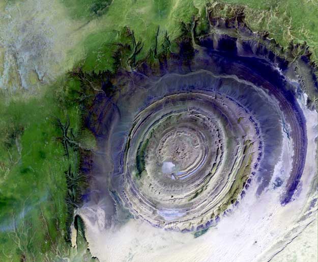
Earth's Richat Structure
Credit: Landsat 7, USGS, NASA
Explanation: What on Earth is that? The Richat Structure in the Sahara Desert of Mauritania is easily visible from space because it is nearly 50 kilometers across. Once thought to be an impact crater, the Richat Structure's flat middle and lack of shock-altered rock indicates otherwise. The possibility that the Richat Structure was formed by a volcanic eruption also seems improbable because of the lack of a dome of igneous or volcanic rock. Rather, the layered sedimentary rock of the Richat structure is now thought by many to have been caused by uplifted rock sculpted by erosion. The above image was captured last year by the orbiting Landsat 7 satellite. Why the Richat Structure is nearly circular remains a mystery.
TOPICS: Astronomy; Astronomy Picture of the Day; Science
KEYWORDS: crater; desert; erosion; geology; image; landform; landsat; lookalike; mauritania; photography; richat; richatstructure; rock; saharadesert; satellite; structure
Astronomy Fun Fact:Here's proof that one has to be careful in any interpretation of what we see, whether it be on Earth or in a distant galaxy. Wouldn't you think "impact crater" if you saw this type of structure on Mars, for instance?
50 kilometers is about 30 miles.
To: MozartLover; Joan912; NovemberCharlie; snowfox; Dawgsquat; viligantcitizen; theDentist; ...
To: petuniasevan
That is a cool picture.
To: petuniasevan
Thanks for the ping & good morning
4
posted on
10/28/2002 12:32:54 AM PST
by
firewalk
To: petuniasevan
Thanks for the ping.
To: petuniasevan
Wonderful image!
To: petuniasevan
Very strange feature.
To: petuniasevan
Looks like the structure above a salt dome. Any maps of this structure showing dips?
8
posted on
10/28/2002 7:07:28 PM PST
by
Graewoulf
To: Graewoulf
I can't find any topo map of the structure.
Here's what a NASA page had to say:
"Initially interpreted as a meteorite impact structure because of its high degree of circularity, it is now thought to be merely a symmetrical uplift (circular anticline) that has been laid bare by erosion. Paleozoic quartzites form the resistant beds outlining the structure. The reason for the high degree of circularity is not clear."
http://eob.gsfc.nasa.gov/NaturalHazards/natural_hazards_v2.php3?img_id=2124
Disclaimer:
Opinions posted on Free Republic are those of the individual
posters and do not necessarily represent the opinion of Free Republic or its
management. All materials posted herein are protected by copyright law and the
exemption for fair use of copyrighted works.
FreeRepublic.com is powered by software copyright 2000-2008 John Robinson

