What an incredible dataset to look at.
Posted on 12/18/2024 6:09:03 PM PST by Tom Tetroxide
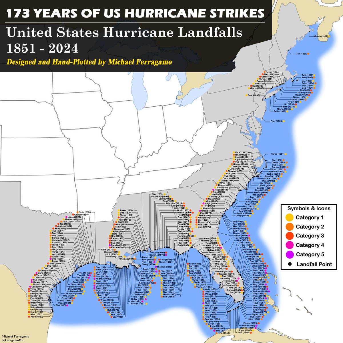
It's finally done. Over 3 days of hand-plotting 173 years' worth of data. The end result is unbelievable.
What an incredible dataset to look at.
A note from Michael Ferragamo....
“Quite a bit of confusion about why SANDY 2012 isn’t on this list. Sandy was officially classified as extratropical a few hours before striking NJ, thus was not a hurricane at landfall.
Yes, it still had 80 mph winds, however it was no longer a fully tropical hurricane.”
Nice!
How does DelMarVa escape over the decades?
Have no idea.
Amazing map!
This one has always been my favorite:
And this graph has no peer in the mirth it provokes in me!
“How does DelMarVa escape over the decades?”
That struck me too, and only one in New Jersey. Only one between Nag’s Head NC and New York. Is it because of the indentation of the coast?
it seems hurricanes never make left turns, so the only way to get to delmarva is to go thru NC first
Yes, due to the earth’s rotation. Same reason why weather fronts in general go from west to east.
bttt
Bump cool map
“...because of the indentation of the coast?”
My first thought.
I would be interesting to see a plot of river water outflow volume.
Maybe having the Chesapeake Bay behind the DMV Peninsula helps too?
Because to get a hurricane to move left (west) that far north you need a very strong high pressure to the north and no low to the west (which drives storms north)
Climatology that’s rare in that location
Hurricane sandy in 2012 found that gap but it lost its tropical characteristics by the time it hit southern NJ so it’s referred to as a Superstorm sandy
They are so lucky. It must be the Chesapeake bay that protects the three states.
“...it seems hurricanes never make left turns...”
Above a certain latitude, I’d agree.
Plenty of wandering in the Mexican/US Gulf.
This is a great plot to help one decide where to retire to if one is interested in the East Coast.
One of the wildest ones roared across Luzon (large northern Philippine island Manila is on) a few years back. Then it looped back and carved up more of Luzon.
I retired to Florida when it was affordable. That’s definitely no longer the case. Delaware looks interesting with no state taxes. I may look into it sometime.
It must be the Chesapeake bay that protects the three states.
——-
It has more to due with steering currents (see post 13)
Typically the Bermuda high is in the mid Atlantic
If it extends west Storms will move into the Gulf
Otherwise storms move around it north on its west side up the coast
A trough of low pressure is often over the central and eastern US also tugging storms north
Most of the Long Island hits are from North to north- northeast moving storms in the above steering currents moving just off the coast
In these common steering set ups any storms just west of that path will simply hit NC
Instead of, MD or DE
Disclaimer: Opinions posted on Free Republic are those of the individual posters and do not necessarily represent the opinion of Free Republic or its management. All materials posted herein are protected by copyright law and the exemption for fair use of copyrighted works.
