Posted on 12/24/2023 10:46:42 PM PST by DigitalVideoDude
NASA’s MERRA-2 climate model reveals that the Arctic stratosphere has reached a 40-year record low for December, creating a sudden appearance of polar stratospheric clouds (PSCs) far beyond their usual Arctic confines.
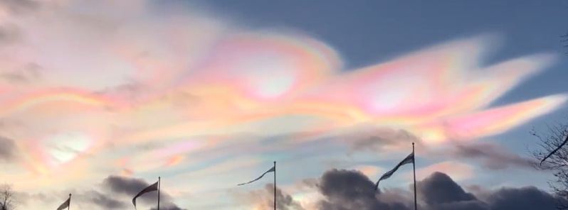
Recent observations have revealed a remarkable surge in polar stratospheric clouds (PSCs), often referred to as the most beautiful clouds on Earth due to their aurora-like colors.
This sudden increase is attributed to a 40-year record low in temperatures within the Arctic stratosphere for the month of December, as indicated by NASA’s MERRA-2 climate model.
PSCs form under extremely cold conditions, typically around -85 °C (-121 °F), in the otherwise cloudless stratosphere. The unusual cold snap has caused these clouds, usually confined to the Arctic, to descend all the way to mid-latitudes.
Notable sightings have been reported over Locarno, Switzerland, Torun, Italy, and Lausanne, Switzerland, locations well beyond the normal range of PSCs.
This phenomenon represents a significant deviation from the typical January start of the PSC season. The current extreme cold wave has not only given rise to an early onset of these clouds but also suggests the potential for increased occurrences in the coming weeks.
On December 24, 2023, the Arctic stratosphere is warming but it’s still cold enough for polar stratospheric clouds.
I blame the Germans. Germany shut down those nasty nuclear power plants and switched back to coal.
Environmental changes such as global cooling perhaps?
Oh no we’re all gonna die again. Everybody panic. It’s suppose to be hot not cold. Where is saint Greta?
Air Weather Service 1973-1977
On a somewhat related note, it is going to be that warmer and wetter than normal this week weather wise for my locale, however, Environment Canada also lists for Christmas Day and Boxing 1982 as the warmest with it being 54.5 F and 50.5 respectively. Also, the wettest Christmas weeks were in 1941 with 1.4 inches of rain received on Christmas Eve, 1.02 inches on Christmas Day 1979, and 1.25 on Dec 29 1940.
I get the impression that the media likes to portray years past as having picture perfect Christmas season weather, however, as one can see, weather extremes have gone on for forever and December has always been very up and down (at least in my locale). BTW, I converted the numbers to make things easier for people here.
Cold but we can handle it. Still a long way to go to Absolute Zero.
And speaking of weather, Santa brought me a new Accurite weather station to replace my old dying one.
Way cool. New background on my monitor.
Now there reporting climate model results as if the were observations.
AWS, stationed with the Army 70-73
6th Weather Sq, Rawinsonde, 69-70
Just the other day algore spewed unhinged global warming porn on CNN. He is a loathsome manbearpig.
Would have been a 50 year low without man made global warming. Btw - how are those electric polar exploration vehicles working out?
Yet another upside to global warming — awesome looking clouds.
Do not lick carbon dioxide snow... it causes cavities
Yeah but if it wasn’t Fer climate change, it might have been -122
“model reveals”? I’m confused. Again. Can’t they like just measure the temperature? Wouldn’t that be more convincing?
I wonder if the water vapor injected into the Stratosphere by that Pacific volcanic eruption a couple years back made this more likely to happen?
I wonder how much of this water vapor in the stratosphere is attributable to Hunga Tunga volcano? It seems the effects of that may be with us for a very long time.
Disclaimer: Opinions posted on Free Republic are those of the individual posters and do not necessarily represent the opinion of Free Republic or its management. All materials posted herein are protected by copyright law and the exemption for fair use of copyrighted works.