Posted on 08/29/2023 10:54:31 AM PDT by Red Badger
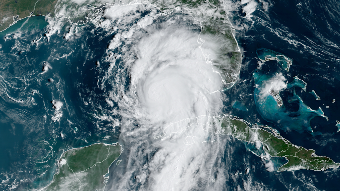
Visible satellite view on Hurricane Idalia intensifying over the Gulf of Mexico on Aug. 29. Image: CIRA/RAMMB
Hurricane Idalia is rapidly intensifying Tuesday as it moves over record-warm waters in the Gulf of Mexico.
Threat level: The storm will bring "catastrophic impacts from storm surge inundation" into Florida's Big Bend, with a "life threatening" surge southward to Tampa Bay, the National Hurricane Center warns.
Idalia was expected to strike Florida's Gulf coast on Wednesday as an "extremely dangerous" major Category 3 storm.
According to the NWS forecast office in Tallahassee, no storm since reliable records began in 1851 has tracked right into Apalachee Bay, as Idalia is forecast to do.
The shape of this region's coastline and shallow continental shelf offshore makes it a storm surge magnifier, with the NWS warning of "potentially devastating" storm surge impacts.
"There are NO major hurricanes in the historical dataset going back to 1851 that have tracked into Apalachee Bay. None," the NWS Tallahassee office wrote in a forecast discussion. "Don`t mess around with this."
State of play: At 11am ET, the hurricane was located about 275 miles south-southwest of Tampa, Fla., with maximum sustained winds of 85 mph. It was moving north at 14 mph.
Driving the news: Hurricane forecasters are forecasting the storm to leap from a Category 1 storm to Category 3 between Tuesday and Wednesday morning, with landfall expected during the day on Wednesday.
President Biden approved the state's emergency request and pledged federal disaster relief assistance during a phone call with Gov. Ron DeSantis on Monday.
Tampa International Airport is closed Tuesday in advance of the storm. Tampa-area counties began carrying out evacuations on Monday.
Zoom in: Idalia is expected to make landfall somewhere between Tampa and Tallahassee on Wednesday, but high winds and storm surge flooding are likely to begin in these areas as early as Tuesday evening.
A hurricane warning is in effect for the Gulf coast of Florida, from just north of Sarasota northward into the Florida Panhandle. This includes Tampa Bay.
A storm surge warning has also been issued from north of Point Charlotte to Indian Pass, Fla., including Tampa Bay.
Tropical storm and storm surge watches have been issued for the Atlantic coast of Florida north to South Carolina.
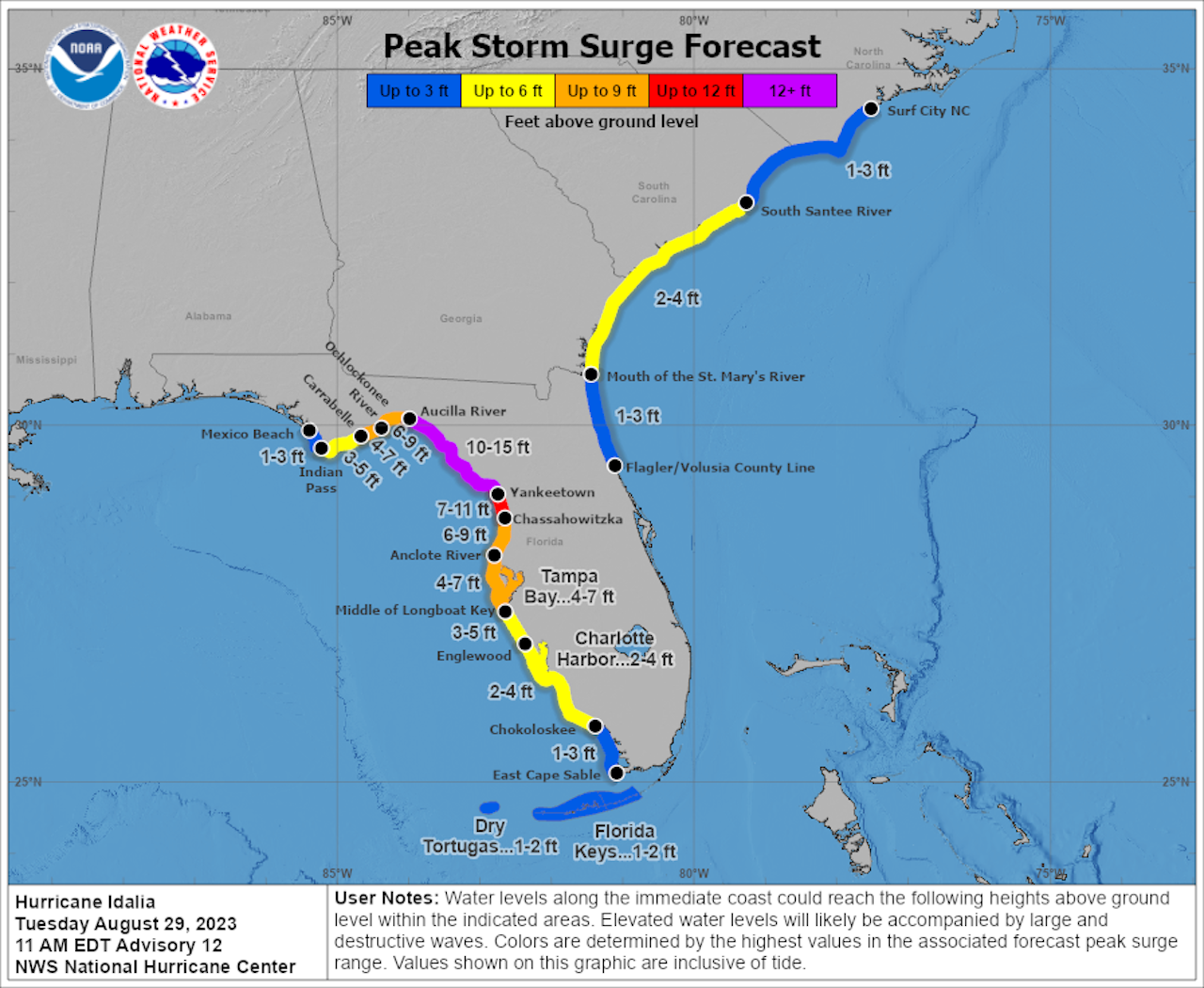
The peak surge forecast for Florida's Big Bend region calls for waters to potentially reach 10 to 15 feet above normally dry ground at high tide.
"Regardless of the cyclone's landfall intensity, there is increasing confidence of a significant storm surge event," NHC forecasters warned in an online forecast discussion. Map showing the peak storm surge forecast from Hurricane Idalia, showing the maximum surge in Florida's Big Bend region.
Peak storm surge forecast as of 11am ET on Aug. 29. Image: NOAA/NHC Between the lines: Tampa is located in a forecast zone projected to see 4 to 7 feet of storm surge flooding, though small changes in the storm's track and intensity could bring a higher surge into Tampa Bay.
If the storm hits at high tide, even the currently forecast surge could yield a record-high water level in Tampa Bay, especially because of astronomical high tides on Wednesday as well.
Heavy rainfall is also a threat from this storm, with amounts in Florida, Georgia and eventually the Carolinas reaching as high as 1 foot.
Forecasters are emphasizing that the forecast "cone of uncertainty" does not depict the full geographic scope of storm impacts, but rather only the probability of where the storm center may travel.
Of note: During the past few years, Florida has been hit with multiple storms along its Gulf coast that have intensified at rapid rates up through landfall, a process linked in part to climate change.
Sea surface temperatures along Idalia's forecast track currently average close to 90°F. These warm waters extend well beneath the ocean surface, providing a deep reservoir of heat for the storm to tap into. Go deeper:
We just went through this canned narrative here in SW Arizona over fizzlecane Hilary.
I have been thru 5 hurricanes and several TS.
I have seen the damages of a Cat 5, Michael, that hit Panama City and Mexico Beach.
The Gulf waters are extremely warm, and Idalia could spin up rather quickly, like Camille in 1969................
I am in Inverness which is 30 miles inland from the gulf coast and currently well outside the projected cone, hope it stays that way. We are prepped anyway & expect some wind and rain, hope it stays its course and doesn’t get bigger that the projected cat3.

And the climate liars are hoping for severe damage and many deaths, so they can say “See? I told you so!”
The initial forecast was for a Cat 1 but with the water temperatures in the gulf being hurricane rocket fuel, I figured it would intensify even more.
Any word on how badly western Cuba suffered?
Maybe the jail flooded...
It’s only forecast to be a Cat 3. They’re making it sound like a Cat 5.
Hysteria rules the MSM.
It improved greatly..........................
A friend of mine bought a townhose in Tampa. They left Kentucky Sunday with all their stuff to get it to the townhouse. It’s been an interesting trip...
Donna is the storm my older relatives all talked about.
Before I was born but it was memorable .
Cuba .
No one could tell the difference .
Same beat up homes , no roads ,no electricity , no water , and ancient cars that look like hell .
>>I don’t know why, but I’m having the feeling this may not be as bad as they’re playing it up to be . . . I confess . . . I’m weird.
Looking where it is supposed to hit, I think only about 6 people live there - so hopefully will not be a major impact.
Climate change real or not - I had to give up my plans for retiring to Florida...doesn’t matter what I think about risks of the climate changing, only what the insurance companies think. At this rate there will be no ins companies left to buy from and I am not rich enough to go without coverage.
“The initial forecast was for a Cat 1 but with the water temperatures in the gulf being hurricane rocket fuel, I figured it would intensify even more.”
Michael in 2018 did just that. Within hours it rocketed into just under a 5 and wiped out Panama City. I think at 6pm the news said go to bed because there is nothing to worry about. At 9:00pm, just 3 hours later, the news was screaming, “Run for your lives!!!”
Sounds like the kind of place where looters would be shot.
Article:
“a process linked in part to climate change”
They just don’t quit—24/7 brainwashing propaganda.
I was a nine year old tyke when this storm hit. I can recall the howling winds and bentover palm trees well. A big mess. I doubt Idalia will be as strong.
Dang that there global warming...
If there were no hurricanes, they would blame that on climate change as well.
Disclaimer: Opinions posted on Free Republic are those of the individual posters and do not necessarily represent the opinion of Free Republic or its management. All materials posted herein are protected by copyright law and the exemption for fair use of copyrighted works.