Skip to comments.
Drone footage shows Indonesia tsunami devastation after 10ft wave wipes WARNINE GRAPHIC PICS
dailymail ^
| 9/30/18
| Miranda Aldersley and Greta Levy and George Martin For Mailonline
Posted on 09/30/2018 2:29:24 PM PDT by ColdOne
Full title...............Drone footage shows Indonesia tsunami devastation after 10ft wave wipes out a beach festival - sweeping away partygoers, obliterating two towns killing 832...............WARNING GRAPHIC CONTENT: 832 people have been killed after a 6.1 magnitude tremor hit the central Indonesian island of Sulawesi on Friday followed by a massive 7.5 magnitude earthquake Indonesia's disaster agency's Sutopo Purwo Nugroho withdrew an earlier warning to residents of a tsunami But three hours later Indonesia's geophysics agency said there had been one, and hundreds have now died The cities of Palu and Donggala were struck by 10ft waves which demolished houses and
(Excerpt) Read more at dailymail.co.uk ...
TOPICS: Local News
KEYWORDS: donggala; eruption; indonesia; krakatoa; palu; sulawesi; tsunami; tsunamis; volcano; warnine
Navigation: use the links below to view more comments.
first previous 1-20, 21-33 last
To: ColdOne; GOP Poet; DoughtyOne; BenLurkin
Both towns (Palu and Dongala) are situated as vulnerable tsunami targets. Palu is at the end of a long, narrow river estuary, which funneled and focused the tsunami right into its center.
The "destroyed fishing village" of Dongala is on the beach, out on a point at the mouth of the estuary -- perfectly sited to catch the full force of a tsunami.
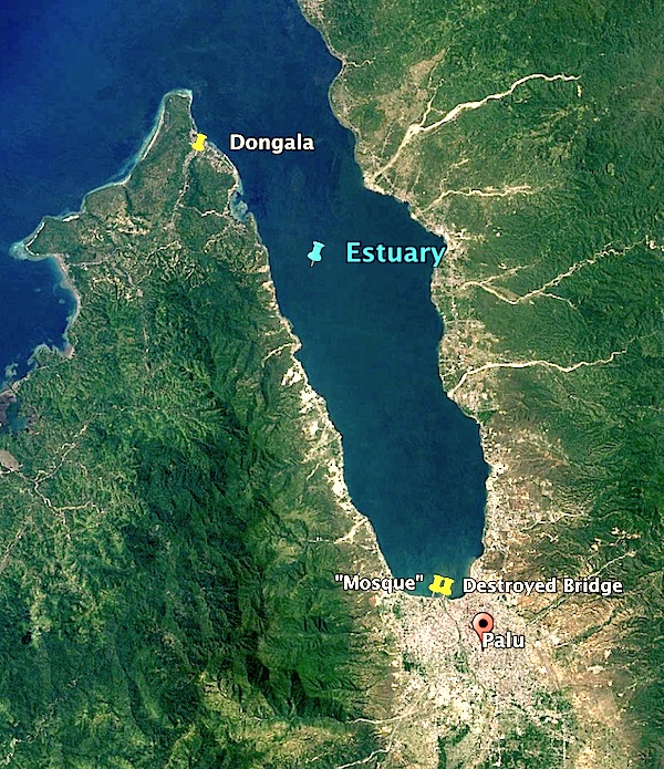
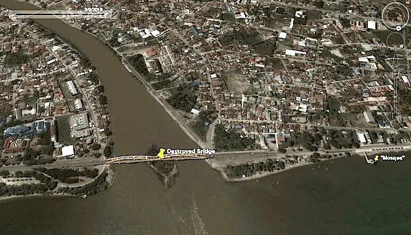
Palu is also a river valley, situated to force the wave to run the maximum distance inland -- with its most important bridge right on the beach -- at the very mouth of the river.
~~~~~~~~~~~
Look at that top photo. You'd think that folks living on the "Ring of Fire" -- on an island in the middle of an ocean prone to tsunamis -- would notice all that nice, undeveloped, elevated ground that surrounds their suicidal townsites...

SMH...
TXnMA

21
posted on
09/30/2018 5:43:32 PM PDT
by
TXnMA
("Allah": Satan's current alias. "Islam": Satan's invading army. "Muslims": Satan's useful idiots.)
To: TXnMA
...would notice all that nice, undeveloped, elevated ground that surrounds their suicidal townsites... When the principal mode of transportation is walking or boating, low flat land close to the river is chosen first and has the most value.
Although one would expect them to be in better shape due to all that walking, maybe modern, Western values will impart themselves on these folks and they will grow up and not just out.
It really seems densely populated. Is their entire life centered on the river?
22
posted on
09/30/2018 5:53:51 PM PDT
by
texas booster
(Join FreeRepublic's Folding@Home team (Team # 36120) Cure Alzheimer's!)
To: TXnMA
Thanks for the photos. The problem with those inlets, is that the water is landlocked, and it swells right up to the lowland focal point. Sad...
23
posted on
09/30/2018 5:55:00 PM PDT
by
DoughtyOne
(01/26/18 DJIA 30 stocks $26,616.71 48.794% > open 11/07/16 $215.71 from 50% increase in 1.2183 yrs)
To: texas booster
I recall that, in the latest Japanese tsunamis, numerous Nihonjin told of being saved by simply walking/running up the gently-sloping paths that led to hillside/hilltop Shinto shrines.
My point was not to build landslide-prone hillside cities (a la Californica). Rather, to -- at least -- provide easily-accessible refuge routes. After all, you don't have to climb but few feet to escape a tsunami...
I see nothing of that sort on Sulawesi... And, I don't expect them to build them -- even after this disaster...
TXnMA
24
posted on
09/30/2018 6:27:59 PM PDT
by
TXnMA
("Allah": Satan's current alias. "Islam": Satan's invading army. "Muslims": Satan's useful idiots.)
To: DoughtyOne
You're welcome...
When you have a tidal or sluggish river at a tsunami impact point, the wave can often run for miles up the reversed stream. Looking back over time, I didn't see any tidal reversals in that stream -- but neither did I see any rapids indicating any significant gradient.
And, that river is clearly "at the neck of the funnel"...
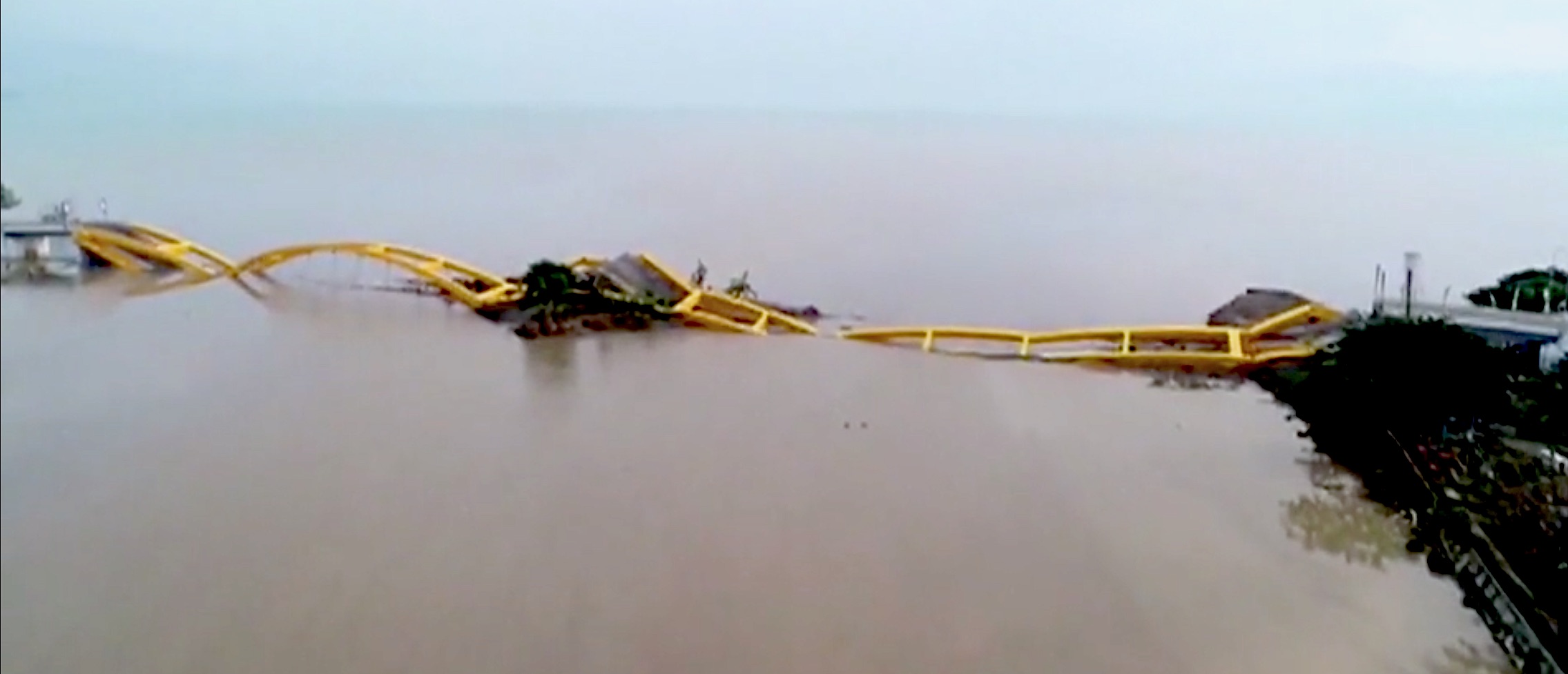
It's not often that you see bridge trusses mangled like that.
TXnMA
25
posted on
09/30/2018 6:36:34 PM PDT
by
TXnMA
("Allah": Satan's current alias. "Islam": Satan's invading army. "Muslims": Satan's useful idiots.)
To: TXnMA
The wave seemed to have come at a pretty bad angle. Not sure if it hit just right, but at least bad enough.
I was thinking about tsunamis the other day.
Is there always a big pull out of water, before the tsunami hits?
I know sometimes there is.
26
posted on
09/30/2018 6:39:25 PM PDT
by
DoughtyOne
(01/26/18 DJIA 30 stocks $26,616.71 48.794% > open 11/07/16 $215.71 from 50% increase in 1.2183 yrs)
To: ColdOne
27
posted on
09/30/2018 6:45:08 PM PDT
by
Trailerpark Badass
(There should be a whole lot more going on than throwing bleach, said one woman.)
To: DoughtyOne
Most of the people I have talked to that went through the tsunami that hit Cresent City in 1964 said most of the damage was done when the water receded afterwards.
28
posted on
09/30/2018 6:45:46 PM PDT
by
Lurkina.n.Learnin
(Wisdom and education are different things. Don't confuse them.)
To: TXnMA
“...would notice all that nice, undeveloped, elevated ground that surrounds their suicidal townsites... “
Probably a dozing volcano...
29
posted on
09/30/2018 7:10:25 PM PDT
by
PLMerite
("They say that we were Cold Warriors. Yes, and a bloody good show, too." - Robert Conquest)
To: Lurkina.n.Learnin
That could be true.
Going in it may dislodge a lot of stuff, and then coming back out, it all rakes the area.
30
posted on
09/30/2018 7:18:56 PM PDT
by
DoughtyOne
(01/26/18 DJIA 30 stocks $26,616.71 48.794% > open 11/07/16 $215.71 from 50% increase in 1.2183 yrs)
31
posted on
10/01/2018 3:46:46 AM PDT
by
glock rocks
(... so much win!)
To: ColdOne
Neptune kicks allah’s butt
32
posted on
10/01/2018 5:02:24 AM PDT
by
kanawa
(Trump Loves a Great Deal)
To: AdmSmith; AnonymousConservative; Berosus; Bockscar; cardinal4; ColdOne; Convert from ECUSA; ...
33
posted on
10/03/2018 1:24:56 PM PDT
by
SunkenCiv
(www.tapatalk.com/groups/godsgravesglyphs/, forum.darwincentral.org, www.gopbriefingroom.com)
Navigation: use the links below to view more comments.
first previous 1-20, 21-33 last
Disclaimer:
Opinions posted on Free Republic are those of the individual
posters and do not necessarily represent the opinion of Free Republic or its
management. All materials posted herein are protected by copyright law and the
exemption for fair use of copyrighted works.
FreeRepublic.com is powered by software copyright 2000-2008 John Robinson