Skip to comments.
Micro To Macro Mapping -- Observing Past Landscapes Via Remote-sensing
Popular Archaeology ^
| Friday, February 09, 2018
| University of Cambridge news release
Posted on 02/18/2018 3:55:08 PM PST by SunkenCiv
Remotely detecting changes in landforms has long relied upon the interpretation of aerial and satellite images... More recently, data produced by photogrammetry and Light Detection and Ranging (LiDAR) models have become commonplace for those involved in geographical analysis - engineers, hydrologists, landscape architects and archaeologists...
In new research published this week in the journal Earth Surface Processes and Landforms, Cambridge archaeologists present a new algorithm, Multi-Scale Relief Model (MSRM), which is able to extract micro-topographic information at a variety of scales employing micro-, meso- and large-scale digital surface (DSM) and digital terrain (DTM) models...
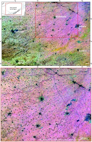
The TwoRains multitemporal remote sensing approach has had an important impact as it was able to find and accurately trace more than 8,000km of relict water courses; the image of which has been selected as the cover image of this year's Cambridge Science Festival (see image above).
However, the authors were conscious that many ancient rivers were not being found... nderstanding how the Indus civilisation accessed and managed their water resources is at the heart of the TwoRains Project.
(Excerpt) Read more at popular-archaeology.com ...
TOPICS: History; Science; Travel
KEYWORDS: godsgravesglyphs; harappan; tworainsproject
A composite image of vegetation indices in Northwest India created from 1254 images reveals a complex palaeoriver network comprised of more than 8000km of palaeochannels. The new MSRM algorithm will contribute to mapping the complete ancient palaeoriver network of northwest India and to a better understanding of how the Indus Civilisation operated c. 2600-1900 BC. Hector A. Orengo
1
posted on
02/18/2018 3:55:09 PM PST
by
SunkenCiv
To: TXnMA; StayAt HomeMother; Ernest_at_the_Beach; 1ofmanyfree; 21twelve; 24Karet; 2ndDivisionVet; ...
2
posted on
02/18/2018 3:57:11 PM PST
by
SunkenCiv
(www.tapatalk.com/groups/godsgravesglyphs/, forum.darwincentral.org, www.gopbriefingroom.com)
To: SunkenCiv
Don’t tell the Hoffmans - they’ll pack up and head out on another quixotic gold rush.
Thar’s gold in them thar paleochannels!
3
posted on
02/18/2018 6:15:06 PM PST
by
Noumenon
(It isn't racist if it's true, is it?)
To: SunkenCiv
There is a 1850's dugout in Palo Pinto County I never did find. Can they help me out?
It's just NW of Lipan.
4
posted on
02/18/2018 6:18:17 PM PST
by
Deaf Smith
(When a Texan takes his chances, chances will be taken that's fore sure)
Disclaimer:
Opinions posted on Free Republic are those of the individual
posters and do not necessarily represent the opinion of Free Republic or its
management. All materials posted herein are protected by copyright law and the
exemption for fair use of copyrighted works.
FreeRepublic.com is powered by software copyright 2000-2008 John Robinson
