Posted on 01/26/2012 12:04:04 PM PST by JustaDumbBlonde

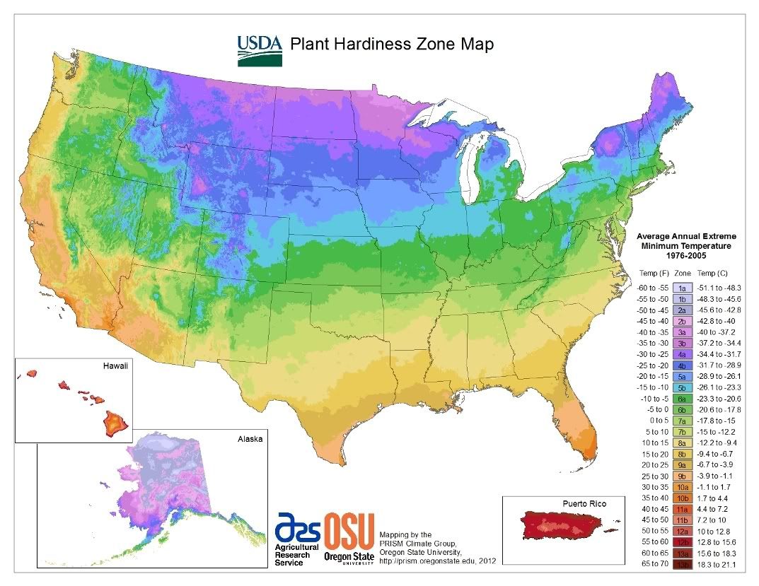
USDA Unveils New Plant Hardiness Zone Map
The U.S. Department of Agriculture (USDA) today released the new version of its Plant Hardiness Zone Map, updating a useful tool for gardeners and researchers for the first time since 1990 with greater accuracy and detail. The new map — jointly developed by USDA's Agricultural Research Service and Oregon State University's PRISM Climate Group — is available online at http://www.planthardiness.ars.usda.gov . ARS is the chief intramural scientific research agency of USDA.
For the first time, the new map offers a Geographic Information System based interactive format and is specifically designed to be Internet-friendly. The map website also incorporates a "find your zone by ZIP code" function. Static images of national, regional and state maps have also been included to ensure the map is readily accessible to those who lack broadband Internet access.
"This is the most sophisticated Plant Hardiness Zone Map yet for the United States," said Dr. Catherine Woteki, USDA Under Secretary for Research, Education and Economics. "The increases in accuracy and detail that this map represents will be extremely useful for gardeners and researchers."
Plant hardiness zone designations represent the average annual extreme minimum temperatures at a given location during a particular time period. They do not reflect the coldest it has ever been or ever will be at a specific location, but simply the average lowest winter temperature for the location over a specified time. Low temperature during the winter is a crucial factor in the survival of plants at specific locations.


(Excerpt) Read more at usda.gov ...
Each week on The Weekly Gardening Thread, I will post a link back to this thread, so it will be handy.
Weekly Gardening Thread (Catalog Fever) Vol. 1 Jan 6, 2012
Weekly Gardening Thread (Seeds) Vol. 2, January 13, 2012
Weekly Gardening Thread Vol. 3, January 20, 2012
Thanks momtothree for the heads up to this information!
Here are the state-specific links:
Detailed State Plant Hardiness Zone Maps
International Plant Hardiness Zone Maps
Australia
Canada
China
Europe
Japan

See you all tomorrow on the regular weekly thread. It may be a bit late because I have to attend a funeral in the morning. Take care ...
I think it gets my area right. Brings zone 6a right up the Mississippi valley to Keokuk, in the ‘Florida of Iowa’ which is always just a bit warmer than us 20 miles to the north, and we’re often a bit warmer than the rest of the state.
Finally a zone map that is not confusing for my area, Meridian, Ms. I could never tell from the old map if I was in a 7b or 8a. There were dips of 7b into the 8a zone right on top of me. Now I am in a solid 8a and so is Marshall, Tx where we are moving.
Thanks for the map.
I live in Southern California where there are a zillion micro-climates because of the hills and valleys, large and small. What grows on the next block does not necessarily do well in my yard.
It’s almost been hit and miss, but these maps do help.
I only wish I could enter my zip code to get a bit more specific.
Thank you for the post.
I am a ‘wee’ bit surprised the government has not informed US these ZONES are in flux due to man made climate change.
The state maps indicate what I have long suspected—the part of OH I’m in is warmer than most of the state, and more like northern Kentucky.
Well worth a look.
The National Gardening Asso. still has the old map up and when I enter my zip code it tells me I am in 7b. 7b is kind of an peninsula dipping down into the middle of the 8a zone. I never understood this. I hope this new map is correct and not based on Political Correctness, e.g. global warming!
WOW - that was a lot of work. Thank you my friend!!!!!!!!!
This map is what I was asking about last week. Thanks so much.
Thanks for the maps.
You can enter your zip code at the site but remember that's the zone for that post office and not necessarily your garden. Type in the surrounding zips just in case. Check the state map link and zoom in to make sure if you're close to a boundary.
I’ve already seen a Lefty AGW-believer spouting off about this map, yelling SEE, SEE, THERE REALLY IS AGW, THEY HAD TO RE-DO THE MAP!
Idiots.
It’s all right, Lefty useful idiots are already claiming that for them.
That’s great. It’s easy to read, for a change. I’m 5b, right along the western coast of Lake Michigan just north of Milwaukee. Diana is in 5a, due west of me in Dane County (Madison). I was surprised to se the temperature differences between 5a and 5b. I’ll probably still plant to Zone 4 for perennials and shrubs.
Thanks, I always thought I was 6a, but now looks like 6b ... nice to know!
I’m now solidly 8b, where I used to be solidly 8a.
You’re most welcome!
You betcha!
Disclaimer: Opinions posted on Free Republic are those of the individual posters and do not necessarily represent the opinion of Free Republic or its management. All materials posted herein are protected by copyright law and the exemption for fair use of copyrighted works.