Skip to comments.
Utah Tribes: “Myself in the Water” -
Thunderbird Foundation for the Arts ^
| 10/15/2011
| Nelson Wadsworth
Posted on 11/16/2011 1:18:10 PM PST by Utah Binger
Photographs by John K. Hillers from the John Wesley Powell Expedition of 1872
Mt. Carmel, UTAH – October 12, 2011 - From October 15, 2011 through December 31, 2011, the Thunderbird Foundation for the Arts will present Utah Tribes: “Myself in the Water” – Photographs by John K. Hillers from the John Wesley Powell Expedition of 1872. This is only the second large-scale exhibition of these rare, original prints since the Foundation obtained them in 1999.
Photographer John (Jack) K. Hillers (1843-1925) made the 116 images of the Utah Tribes Exhibit while he was working with the legendary U.S. explorer and scientist John Wesley Powell during the federally funded survey of the Colorado Plateau in 1872-1875. Powell was not only interested in the geology of the Colorado River region, but also in the native populations who dwelt in the environs of the plateaus.
In the fall of 1872 Powell set out to photograph the Kaibab Paiutes, who at the time were settled in their winter camp at the mouth of Kanab Canyon, not far from the Mormon settlement of Kanab. Earlier attempts to photograph the Paiutes had been unsuccessful because the Indians feared the camera. But now, accompanied by southern Utah Mormon leader Jacob Hamblin, the so-called “buckskin apostle” to the Indians, Powell met with the leader of the Kaibab Paiute band, Chuarumpeak. With Hamblin’s reassurance, the Paiutes were at last convinced the camera would do them no harm, and they gave Hillers the Indian name of “Myself in the Water,” symbolic of his camera being able to capture their own reflections in the water in his magic wooden box.
Thus began a long association of mutual trust between Powell and the Paiutes, which freely opened access to Hillers’ cameras. Many of the pictures in the Utah Tribes Exhibit are the result.
The exhibition will be accompanied by a special reproduction portfolio of 8 simulated photogravures, available for purchase through the Thunderbird Foundation. A show description and preview of close-up detail images from Utah Tribes: “Myself in the Water” is featured on the Foundation website.
TOPICS: Education; History; Society; Travel
KEYWORDS: kaibabplateau; paiutes; powell; southernutah
Navigation: use the links below to view more comments.
first previous 1-20, 21-40, 41-60, 61-73 next last
To: glock rocks; Utah Binger
Thanks, real history is quite rare these days.
21
posted on
11/16/2011 9:37:32 PM PST
by
SouthTexas
(You cannot bargain with the devil, shut the government down.)
To: glock rocks
Thanks for the ping. I need a reason to visit Southern Utah soon.
22
posted on
11/17/2011 3:51:54 AM PST
by
colorcountry
(Comforting lies are not your friends. Painful truths are not your enemies.)
To: colorcountry
-——I need a reason to visit Southern Utah soon-——
Read the “thief of time” by tony hillerman, then go stay in the motel in Bluff. then take a raft ride down the San Juan river to see the fantastic petraglyphs and where Chaco wash enters the river. Then go up on the hill and see the great house ruins.
That might transform a need into urgent action to go
23
posted on
11/17/2011 4:57:56 AM PST
by
bert
(K.E. N.P. +12 ..... Crucifixion is coming)
To: bert
I’m from Panguitch....colorcountry....get it? Sheesh, although I do believe south eastern Utah is beautiful too.
24
posted on
11/17/2011 4:59:47 AM PST
by
colorcountry
(Comforting lies are not your friends. Painful truths are not your enemies.)
To: bert
I’m from Panguitch....colorcountry....get it? Sheesh, although I do believe south eastern Utah is beautiful too.
25
posted on
11/17/2011 4:59:47 AM PST
by
colorcountry
(Comforting lies are not your friends. Painful truths are not your enemies.)
To: colorcountry
Well, yes. I get it now
I love your part of the country and intended to visit this last year. Maybe next year we’ll make it again
26
posted on
11/17/2011 5:22:00 AM PST
by
bert
(K.E. N.P. +12 ..... Crucifixion is coming)
To: bert; Utah Binger; colorcountry; SouthTexas; Brad's Gramma; glock rocks; Jim Robinson; onyx; ...
I’ve been a fan of So. Utah since I moved here 50 years ago and while not a bush hugger by any stretch, have worked hard through the years to keep things out such as strip mining the Kaparowitz plateau and the constructing of the Kaparowitz power plant.
And worked the super fund Uranium tailings cleanup project in the early 80’s
Started boating Lake Powell when the annual visitor numbers were less than 10,000 a year (now over 1 million).
most of my profile page is dedicated to the beauty of So. Utah...
UB I will absolutely try to grab ma and come down to the viewing, I love all the history from the Fremonts all the way back to the Anisazi’s and would enjoy seeing y’all again...
for the non familiar, some pics we’ve taken through the years while traveling to and from powell, I take different routes home to keep the trip from becoming monotonous
http://public.fotki.com/IRTruckn/lake-powell/
http://public.fotki.com/IRTruckn/burr-trail-from-bul/
the top of the Burr trail actually ends up at the East entrance of Capital Reef...
http://public.fotki.com/IRTruckn/capital-reef-along-/
and some pics of UB’s place and last years FR picnic...
http://public.fotki.com/IRTruckn/2011-1st-annual-fr-/
27
posted on
11/17/2011 8:36:18 AM PST
by
Pete-R-Bilt
(I love guns... and coffee!)
To: Pete-R-Bilt
Great! We’ll see you when we see you!
28
posted on
11/17/2011 8:41:00 AM PST
by
Utah Binger
(Southern Utah where INVITED Freepers will meet again next summer. Jim Robinson Too)
To: Pete-R-Bilt
Hiya Pete!
You have lots and lots of beautiful pictures!!!
29
posted on
11/17/2011 8:56:31 AM PST
by
onyx
(PLEASE SUPPORT FREE REPUBLIC BY DONATING NOW! Sarah's New Ping List - tell me if you want on it.)
To: Pete-R-Bilt
Ahhh...... the Burr Trail.
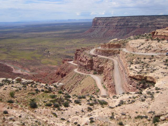
A fantastically beautiful drive. Coming across the ridge and down the Water Pocket fold switchbacks is rivaled only by the Mokee Dugway.
30
posted on
11/17/2011 9:08:04 AM PST
by
bert
(K.E. N.P. +12 ..... Crucifixion is coming)
To: bert
That’s an interesting road, one I used lots of times when we were cleaning up the Uranium tailings.
During the 10 months I worked the project I lived in Mexican hat and hauled dirty tailings out of Fry Cyn to a place we agreed not to disclose for processing the rest was capped and stabilized, areas down there will still set off Geigers
we only pulled 42’ trailers back then(thank goodness) wouldn’t want to pull one of today’s 53’s
31
posted on
11/17/2011 10:06:14 AM PST
by
Pete-R-Bilt
(I love guns... and coffee!)
To: glock rocks
You know, it may be just an amazing coincidence, but my Indian name is Camera In The Water.Mine is (depending on who is doing the naming)...
Lucky Soaring Turkey Vulture
Woman with Broken Heal
Napayshni, meaning strong or courageous
Wind Rider
32
posted on
11/17/2011 3:20:24 PM PST
by
Elsie
(Heck is where people, who don't believe in Gosh, think they are not going)
To: Utah Binger
33
posted on
11/17/2011 3:22:08 PM PST
by
Osage Orange
(Si Vis Pacem, Para Bellum)
To: Utah Binger
Which tribe are you?I'm from Indianpolis Indiana.
How many points does THAT get me? ;^)
34
posted on
11/17/2011 3:22:20 PM PST
by
Elsie
(Heck is where people, who don't believe in Gosh, think they are not going)
To: bert
Read the “thief of time” by tony hillerman, then go stay in the motel in Bluff. Which one?
Desert Rose is a NICE place!
Biggest rooms I've ever stayed in!
Hillerman was my Favorite!
I could SMELL the air fragrance in my mind as I read was he had written about the area in his books!
The Navajo have lost a good friend; and the world will no longer wonder about Chee's and Leaphorn's lovelife.
35
posted on
11/17/2011 3:28:53 PM PST
by
Elsie
(Heck is where people, who don't believe in Gosh, think they are not going)
To: bert
Coming across the ridge and down the Water Pocket fold switchbacks is rivaled only by the Mokee Dugway.Two years ago was my first down the Mokee in the dark. During the day, the view from the top is a vast open emptiness.
I was shocked to see so many electric lights out in the distance at night.
It sure dispeled my notions of what was out there, when my previous data was only what I could see in the day.
36
posted on
11/17/2011 3:33:42 PM PST
by
Elsie
(Heck is where people, who don't believe in Gosh, think they are not going)
To: Pete-R-Bilt
...one I used lots of times when we were cleaning up the Uranium tailings. .
.
.
. we only pulled 42’ trailers back then(thank goodness) wouldn’t want to pull one of today’s 53’sAMEN!
After seeing the carcasses that are over the side on those switchbacks!
Ok; just like a pix of Catherine Zeta-jones needs a balance of Helen Thomas; here is what we are talking about for you folks who have not (yet) driven this road:
37
posted on
11/17/2011 3:38:20 PM PST
by
Elsie
(Heck is where people, who don't believe in Gosh, think they are not going)
To: Elsie
The motel in question is the one depicted in the book “thief of time”. It is on the river. There is a framed letter in the lounge that designates the room as being the center of Bluff as described in his book. It is old but nice and “is In the book”
A short piece beyond is the river outfitter also described and who took us on the ride down the river. We lunched at the place where Chaco wash intersects the river. It is also the site of perhaps the greatest array of petroglyphs existent. It is also the point where Joe Leaphorn left the river and hiked up Chaco wash in search of the Park archeologist
Regarding the view from Cedar Mesa, It does seem to go on forever and is one of the best in the world anywhere. I think driving it at night is a very significant achievement. I’ve been down twice and up once.
There is a lot written about recession, double dip recession. The view from Mule point and the Mokee Dugway are my metaphor for our economy. In late 2008, The country took the drive off the sheer mesa wall and is now on the seemingly endless and flat plateau below. There is a rise now and then but the mountains on the horizon never seem to get much closer.
BTW, in October we spent part of a day in Nauvoo and visited all the historic places there including a really great visitors center. We were on an adventure traveling down the Great River Road from Lake Itaska MN to the rivers end in Venice LA.
38
posted on
11/17/2011 4:08:07 PM PST
by
bert
(K.E. N.P. +12 ..... Crucifixion is coming)
To: bert; Elsie

The American economy (view from the cedar Mesa, Mokee Dugway
39
posted on
11/17/2011 4:10:20 PM PST
by
bert
(K.E. N.P. +12 ..... Crucifixion is coming)
To: Osage Orange
40
posted on
11/17/2011 5:14:21 PM PST
by
Utah Binger
(Southern Utah where INVITED Freepers will meet again next summer. Jim Robinson Too)
Navigation: use the links below to view more comments.
first previous 1-20, 21-40, 41-60, 61-73 next last
Disclaimer:
Opinions posted on Free Republic are those of the individual
posters and do not necessarily represent the opinion of Free Republic or its
management. All materials posted herein are protected by copyright law and the
exemption for fair use of copyrighted works.
FreeRepublic.com is powered by software copyright 2000-2008 John Robinson