Posted on 08/25/2008 8:27:52 AM PDT by NautiNurse
Tropical Depression 7 has formed in the eastern Caribbean.
Buoy Data:
East Caribbean Buoys
West Caribbean Buoys
Florida Buoys
| Category | Wind Speed | Barometric Pressure | Storm Surge | Damage Potential |
|---|---|---|---|---|
| Tropical Depression |
< 39 mph < 34 kts |
Minimal | ||
| Tropical Storm |
39 - 73 mph 34 - 63 kts |
Minimal | ||
| Hurricane 1 (Weak) |
74 - 95 mph 64 - 82 kts |
28.94" or more 980.02 mb or more |
4.0' - 5.0' 1.2 m - 1.5 m |
Minimal damage to vegetation |
| Hurricane 2 (Moderate) |
96 - 110 mph 83 - 95 kts |
28.50" - 28.93" 965.12 mb - 979.68 mb |
6.0' - 8.0' 1.8 m - 2.4 m |
Moderate damage to houses |
| Hurricane 3 (Strong) |
111 - 130 mph 96 - 112 kts |
27.91" - 28.49" 945.14 mb - 964.78 mb |
9.0' - 12.0' 2.7 m - 3.7 m |
Extensive damage to small buildings |
| Hurricane 4 (Very strong) |
131 - 155 mph 113 - 135 kts |
27.17" - 27.90" 920.08 mb - 944.80 mb |
13.0' - 18.0' 3.9 m - 5.5 m |
Extreme structural damage |
| Hurricane 5 (Devastating) |
Greater than 155 mph Greater than 135 kts |
Less than 27.17" Less than 920.08 mb |
Greater than 18.0' Greater than 5.5m |
Catastrophic building failures possible |
Placemark
That will pose a big problem too. With the grounds already saturated flooding will be worse. Yesterday we had a heck of a thunderstorm come through. Not a bunch of rain but really loud thunder and lightening.
That’s bout the very worst thing that can happen...
If the storm hits New Orleans dead on it will be interesting to see how a Republican governor handles it.
On the other hand, don't get your hopes up that the mayor has learned from past experience...
TAW
Now, now... the government wouldn't want to do anything to hurt the "big oils" 30%+ return on equity.
Is not Gustav already playing a very serous game of chess right now?
Yes, substantial GOM South Texas mainland damage. That's what hurt South Padre so bad. The major electrical sub-station in Port Isabel (that feeds SPI) was destroyed and they also had millions $ damage. Also unlike the last major real estate boom in the 80's, SPI has experienced a major construction boom so there is substantially more high dollars property for a hurricane to damage now. When Dolly intensified right before making landfall I knew it was going to do a lot of damage. Thanks for the on-the-ground report.

Meteorologically I think it's called "gorilla foreplay", lol.

Hey NN,
Looking at the storm track...deja vue. But last time the New Orleans folks wouldn’t believe it was going to hit (remember how amazed we were that they weren’t evacuating)...this time, if it still heads that way, I’m sure they’ll take it seriously. Plus Jindal is in charge, and he seems to be making preparations even now.
Jindal has just declared a State of Emergency and activated the National Guard! Hoo-rah!
sw
If this storm takes the track shown in post # 439,
That looks like the mouth of the river,from the SSW,,,
This will push the river as well as the lakes into the city
from both directions,,,
The “Dome”/French Quarter/etc. ,all the areas that didn’t
flood last time could take near 30 feet of water,,,
Bobby is all over this,,,
It won’t matter what Da’Mayor does,,,
The Dead Pelican.com has lots of info...
My son lives in New Orleans as of 3 weeks ago and is prepared to leave any time Friday, or whenever, if an evacuation is ordered. His girlfriend works for AmeriCorps and is going to help people get to evacuation points and then will be put on Amtrak to Memphis, Tn.
It does sound like they are much better prepared down there, although my nerves sure aren’t.
VirginiaMom

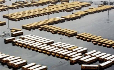
Now in August, some of the elderly & young had problems with heat on the school buses, many of which do not have air conditioning, but it beats being pulled off a roof 3 days later or drowning, I'd think.

-- 08.27.08-19:30 FLORIDA WATCH --
1. UPDATED to high tropical storm formation probability - Thunderstorm activity has become more concentrated this evening with the low pressure system centered about 375 miles east-northeast of the northern leeward islands. Environmental conditions are expected to become more conducive for a tropical depression to form tonight or tomorrow as it drifts northwestward.

This storm looks really bad tonight... I’m almost wondering if it’s been beat up to the point where it might not really come back. If we don’t see much re-organization soon we might get a lucky break here.
This afternoon, the invest looked a lot more organized than Gustav, even though it doesn’t have the winds Gustav does.
I said a special prayer today about Gustav. Will continue to do so. Miracles can and do happen.
Any idea where that picture from Charlotte is? That’s my hometown....
Disclaimer: Opinions posted on Free Republic are those of the individual posters and do not necessarily represent the opinion of Free Republic or its management. All materials posted herein are protected by copyright law and the exemption for fair use of copyrighted works.