Free Republic
Browse · Search
General/Chat
Topics · Post Article

Skip to comments.

Tropical Depression 7
NOAA/NHC ^ | 08/25/2008 | NOAA/NHC

Posted on 08/25/2008 8:27:52 AM PDT by NautiNurse

Tropical Depression 7 has formed in the eastern Caribbean.

Public Advisories

Forecast Discussion

Buoy Data:
East Caribbean Buoys
West Caribbean Buoys
Florida Buoys

Visible Satellite Image

IR Sat Image Loop

Water Vapor Image Loop

Category Wind Speed Barometric Pressure Storm Surge Damage Potential
Tropical
Depression
< 39 mph
< 34 kts
    Minimal
Tropical
Storm
39 - 73 mph
34 - 63 kts
    Minimal
Hurricane 1
(Weak)
74 - 95 mph
64 - 82 kts
28.94" or more
980.02 mb or more
4.0' - 5.0'
1.2 m - 1.5 m
Minimal damage to vegetation
Hurricane 2
(Moderate)
96 - 110 mph
83 - 95 kts
28.50" - 28.93"
965.12 mb - 979.68 mb
6.0' - 8.0'
1.8 m - 2.4 m
Moderate damage to houses
Hurricane 3
(Strong)
111 - 130 mph
96 - 112 kts
27.91" - 28.49"
945.14 mb - 964.78 mb
9.0' - 12.0'
2.7 m - 3.7 m
Extensive damage to small buildings
Hurricane 4
(Very strong)
131 - 155 mph
113 - 135 kts
27.17" - 27.90"
920.08 mb - 944.80 mb
13.0' - 18.0'
3.9 m - 5.5 m
Extreme structural damage
Hurricane 5
(Devastating)
Greater than 155 mph
Greater than 135 kts
Less than 27.17"
Less than 920.08 mb
Greater than 18.0'
Greater than 5.5m
Catastrophic building failures possible


TOPICS: Weather
KEYWORDS: gustav; hurricane; predictions; tropical
Navigation: use the links below to view more comments.
first previous 1-20 ... 421-440441-460461-480 ... 581-592 next last
To: NautiNurse

Placemark


441 posted on 08/27/2008 1:53:12 PM PDT by greyfoxx39 (Romney supporters' sixth sense...."Mommy, I see BIGOTS EVERYWHERE......WAHHHH!)
[ Post Reply | Private Reply | To 440 | View Replies]

To: CindyDawg
Just looking at the maps it looks like where ever Guss goes it’ going to be already wet.

That will pose a big problem too. With the grounds already saturated flooding will be worse. Yesterday we had a heck of a thunderstorm come through. Not a bunch of rain but really loud thunder and lightening.

442 posted on 08/27/2008 1:56:53 PM PDT by girlscout
[ Post Reply | Private Reply | To 435 | View Replies]

To: NautiNurse

That’s bout the very worst thing that can happen...


443 posted on 08/27/2008 2:00:04 PM PDT by 1COUNTER-MORTER-68 (THROWING ANOTHER BULLET-RIDDLED TV IN THE PILE OUT BACK~~~~~)
[ Post Reply | Private Reply | To 439 | View Replies]

To: 1COUNTER-MORTER-68
That’s bout the very worst thing that can happen...

If the storm hits New Orleans dead on it will be interesting to see how a Republican governor handles it.

On the other hand, don't get your hopes up that the mayor has learned from past experience...

444 posted on 08/27/2008 2:12:04 PM PDT by Senator_Blutarski (No good deed goes unpunished.)
[ Post Reply | Private Reply | To 443 | View Replies]

To: NautiNurse
Everybody is getting all gittery down here in Mississippi and the dern thing is still 4 to 5 days out. I've already gotten 2 phone calls about gas going up 10 to 25 cents per gallon just today.

TAW

445 posted on 08/27/2008 2:14:23 PM PDT by Malichi (!)
[ Post Reply | Private Reply | To 440 | View Replies]

To: rodguy911
Do prices still go up if we start drawing from the strategic reserve which is what it was designed for?

Now, now... the government wouldn't want to do anything to hurt the "big oils" 30%+ return on equity.

446 posted on 08/27/2008 2:34:41 PM PDT by flattorney (See my comprehensive FR Profile "Straight Talk" Page)
[ Post Reply | Private Reply | To 397 | View Replies]

To: Constitutionalist Conservative

Is not Gustav already playing a very serous game of chess right now?


447 posted on 08/27/2008 2:52:03 PM PDT by yield 2 the right
[ Post Reply | Private Reply | To 383 | View Replies]

To: CindyDawg
It could have been worse but signs of Dolly are still all around. There was a lot of damage and not just to the Island. Last week I went to Harlingen and there still is a mobile home park of houses with serious roof damage. Many businesses still don't have signs. I think the main reason we aren't getting much media coverage though is that people are repairing and there isn't much grumbling....not the kind of stuff the media is interested in.

Yes, substantial GOM South Texas mainland damage. That's what hurt South Padre so bad. The major electrical sub-station in Port Isabel (that feeds SPI) was destroyed and they also had millions $ damage. Also unlike the last major real estate boom in the 80's, SPI has experienced a major construction boom so there is substantially more high dollars property for a hurricane to damage now. When Dolly intensified right before making landfall I knew it was going to do a lot of damage. Thanks for the on-the-ground report.


448 posted on 08/27/2008 3:15:06 PM PDT by flattorney (See my comprehensive FR Profile "Straight Talk" Page)
[ Post Reply | Private Reply | To 159 | View Replies]

To: yield 2 the right
Is not Gustav already playing a very serous game of chess right now?

Meteorologically I think it's called "gorilla foreplay", lol.


449 posted on 08/27/2008 3:22:43 PM PDT by flattorney (See my comprehensive FR Profile "Straight Talk" Page)
[ Post Reply | Private Reply | To 447 | View Replies]

To: NautiNurse

Hey NN,

Looking at the storm track...deja vue. But last time the New Orleans folks wouldn’t believe it was going to hit (remember how amazed we were that they weren’t evacuating)...this time, if it still heads that way, I’m sure they’ll take it seriously. Plus Jindal is in charge, and he seems to be making preparations even now.


450 posted on 08/27/2008 4:31:51 PM PDT by Dawn531
[ Post Reply | Private Reply | To 440 | View Replies]

To: Dawn531
They should leave New Orleans or forever give up their rights to any assistance.

Jindal has just declared a State of Emergency and activated the National Guard! Hoo-rah!

sw

451 posted on 08/27/2008 4:39:06 PM PDT by spectre (Spectre's wife (Is He the one?)
[ Post Reply | Private Reply | To 450 | View Replies]

To: Senator_Blutarski

If this storm takes the track shown in post # 439,

That looks like the mouth of the river,from the SSW,,,

This will push the river as well as the lakes into the city

from both directions,,,

The “Dome”/French Quarter/etc. ,all the areas that didn’t

flood last time could take near 30 feet of water,,,

Bobby is all over this,,,

It won’t matter what Da’Mayor does,,,

The Dead Pelican.com has lots of info...


452 posted on 08/27/2008 5:02:17 PM PDT by 1COUNTER-MORTER-68 (THROWING ANOTHER BULLET-RIDDLED TV IN THE PILE OUT BACK~~~~~)
[ Post Reply | Private Reply | To 444 | View Replies]

To: Dawn531

My son lives in New Orleans as of 3 weeks ago and is prepared to leave any time Friday, or whenever, if an evacuation is ordered. His girlfriend works for AmeriCorps and is going to help people get to evacuation points and then will be put on Amtrak to Memphis, Tn.

It does sound like they are much better prepared down there, although my nerves sure aren’t.

VirginiaMom


453 posted on 08/27/2008 5:03:25 PM PDT by VirginiaMom (lost in the wilderness)
[ Post Reply | Private Reply | To 450 | View Replies]

To: 1COUNTER-MORTER-68
If what you say is the case, I strongly suggest Mayor Nagin use them THIS time, before he loses them again....


454 posted on 08/27/2008 5:18:44 PM PDT by Alas Babylon!
[ Post Reply | Private Reply | To 452 | View Replies]

To: Alas Babylon!
One of the articles I've seen says Jindal is reserving charter buses, but I know that Savannah uses school buses for hurricane evacuations, or did during Floyd (which actually didn't hit Savannah, but there was an evacuation anyway).

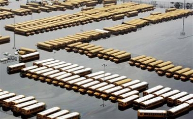
Now in August, some of the elderly & young had problems with heat on the school buses, many of which do not have air conditioning, but it beats being pulled off a roof 3 days later or drowning, I'd think.

455 posted on 08/27/2008 5:39:46 PM PDT by Amelia
[ Post Reply | Private Reply | To 454 | View Replies]

To: NautiNurse

-- 08.27.08-19:30 FLORIDA WATCH --
1. UPDATED to high tropical storm formation probability - Thunderstorm activity has become more concentrated this evening with the low pressure system centered about 375 miles east-northeast of the northern leeward islands. Environmental conditions are expected to become more conducive for a tropical depression to form tonight or tomorrow as it drifts northwestward.


456 posted on 08/27/2008 5:40:49 PM PDT by flattorney (See my comprehensive FR Profile "Straight Talk" Page)
[ Post Reply | Private Reply | To 1 | View Replies]

To: All

This storm looks really bad tonight... I’m almost wondering if it’s been beat up to the point where it might not really come back. If we don’t see much re-organization soon we might get a lucky break here.


457 posted on 08/27/2008 6:10:00 PM PDT by nwctwx
[ Post Reply | Private Reply | To 450 | View Replies]

To: nwctwx

This afternoon, the invest looked a lot more organized than Gustav, even though it doesn’t have the winds Gustav does.


458 posted on 08/27/2008 6:14:31 PM PDT by Amelia
[ Post Reply | Private Reply | To 457 | View Replies]

To: Amelia

I said a special prayer today about Gustav. Will continue to do so. Miracles can and do happen.


459 posted on 08/27/2008 6:24:46 PM PDT by sheikdetailfeather (DRILL HERE-DRILL NOW-PAY LESS)
[ Post Reply | Private Reply | To 458 | View Replies]

To: NautiNurse

Any idea where that picture from Charlotte is? That’s my hometown....


460 posted on 08/27/2008 6:36:31 PM PDT by aberaussie
[ Post Reply | Private Reply | To 407 | View Replies]


Navigation: use the links below to view more comments.
first previous 1-20 ... 421-440441-460461-480 ... 581-592 next last

Disclaimer: Opinions posted on Free Republic are those of the individual posters and do not necessarily represent the opinion of Free Republic or its management. All materials posted herein are protected by copyright law and the exemption for fair use of copyrighted works.

Free Republic
Browse · Search
General/Chat
Topics · Post Article

FreeRepublic, LLC, PO BOX 9771, FRESNO, CA 93794
FreeRepublic.com is powered by software copyright 2000-2008 John Robinson