
Posted on 03/13/2006 12:21:19 PM PST by cogitator
Today's two images are inspired by the "learn something new every day" phenomenon. In this case, the something that was learned was about the Northwest Angle in Minnesota, pictured here (click to go to article, with larger image link).
I wanted to find other images of the Northwest Angle, but couldn't find much. However, I did find the interesting site below, with a virtual tour and smallish excerpts from a Landsat poster of Lake of the Woods. The image below was interesting, especially the circularity of the features in the lower part of the image.
A Virtual Tour of Lake of the Woods

** ping ** ping **
*ping*
The text on the page with that image attributes that geology to a below-surface magma dome emplacement rather than an impact. I was surprised by that; I don't know how "informed" the description is.
NW angle ping
Yes, I question that: Canadian Shield just doesn't have magma domes under it, which are typical of subduction zones and great seismic activity.
Rather the opposite in fact: A magma dome (like the unusual southern granite domes at GA's Stone Mountain and TX's Enchanted Rock don't "stay submerged" either - they are revealed as the surrounding softer rock is eroded away, not revealed by the ridges in overlaying rock.
Enchanted Rock photo's. These are (real) magma domes.
http://austinexplorer.com/Hiking/HikeDetail.asp?HikeID=23
Stone Mountain
http://ngeorgia.com/mountains/stonemountainnh.html
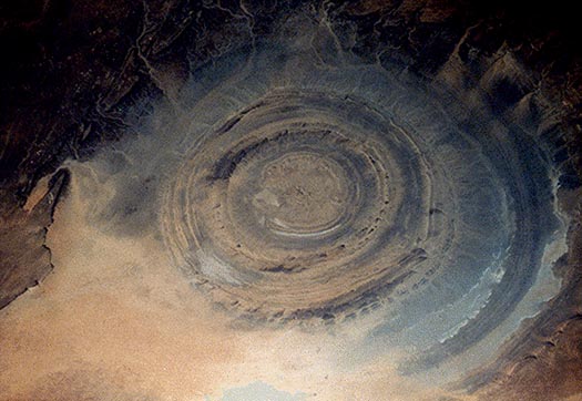
Caption: "What on Earth is that? The Richat Structure in the Sahara Desert of Mauritania is easily visible from space because it is nearly 50 kilometers across. Once thought to be an impact crater, the Richat Structure's flat middle and lack of shock-altered rock indicates otherwise. The possibility that the Richat Structure was formed by a volcanic eruption also seems improbable because of the lack of a dome of igneous or volcanic rock. Rather, the layered sedimentary rock of the Richat structure is now thought by many to have been caused by uplifted rock sculpted by erosion. Why the Richat Structure is nearly circular remains a mystery."
Another picture and caption:
Caption excerpt: "Initially interpreted as a meteorite impact structure because of its high degree of circularity, it is now thought to be merely a symmetrical uplift (circular anticline) that has been laid bare by erosion. Paleozoic quartzites form the resistant beds outlining the structure."
So perhaps my wording was inaccurate; they're attributing the circularity in that part of Lake of the Woods to a "symmetric circular uplift", similar to what formed the Richat Structure. Uplift is what makes mountains; it's unusual to see a circular version.
Whatever it is, it kinda makes your eyes spin when you look at it.
https://earthobservatory.nasa.gov/images/91258/an-unusual-angle
https://earthobservatory.nasa.gov/images/6357/northwest-angle-minnesota
Disclaimer: Opinions posted on Free Republic are those of the individual posters and do not necessarily represent the opinion of Free Republic or its management. All materials posted herein are protected by copyright law and the exemption for fair use of copyrighted works.