Posted on 09/23/2004 4:37:41 AM PDT by Chairman_December_19th_Society
We will not tire, we will not falter, and we will not fail!
Good morning!!
Do not let the victims of the attacks on New York and Washington, nor the brave members of our Nation's military who have given their lives to protect our freedom, die in vain!!
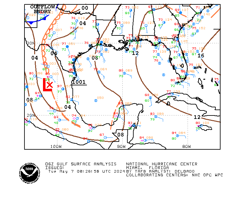
TROPICAL DEPRESSION IVAN ADVISORY #69
[Used in lieu of normal NHC graphic, which was not available.]
DISCUSSION
...IVAN POORLY ORGANIZED...MIGHT STRENGTHEN A LITTLE BEFORE REACHING TEXAS...
IVAN shows little sign of the normal organization associated with a tropical system (maybe because it is really a cut off LP system trying to behave as a tropical system?). There might be some strengthening before it reaches the coast, but the window for that to occur is closing.
IVAN is being steered by the strong mid-level HP center to its north. That center is forecast to weaken over the next 24 hours, and IVAN will slow after it makes landfall.
Rainfall amounts of 5 to 10 inches are possible along and to the right of the track of IVAN, which may result in life-threatening flash floods.
WATCHES/WARNINGS
A TROPICAL STORM WARNING IS IN EFFECT FROM THE MOUTH OF THE MISSISSIPPI TO SARGENT, TX.
STORM DATA
Fix Time: 5 AM ET / 4 AM CT (0900Z)
Location: 28.2N by 91.6W, or near Chattanooga, TN.
Vector: WNW at 15. This motion is expected to continue for the next 24 hours.
Winds: 40 MPH with some higher gusts.
Pressure: 1007 MB or 29.74"
Diameter of Hurricane Force Winds: N/A.
Diameter of Tropical Storm Force Winds: 170 miles.
Anticipated landfall time: 3 AM, Friday, September 24, 2004.
Anticipated landfall location: High Island, TX (about 20 miles NE of Galveston)
HURRICANE LOCAL STATEMENTS
NEXRAD IMAGERY

SLOSH DATA
Surge heights of 2 to 4 feet above normal are expected to the right of the center when IVAN makes landfall.
TOD DATA
Not applicable for a tropical storm.
STATE-ISSUED OFFICIAL EVACUATION INSTRUCTIONS AND OTHER INFORMATION
[None at this time.]
INTEREST WATCH AREA
Interests along the Louisiana and Texas Gulf coasts should monitor the progress of IVAN.
In the news...
Senator John Effin says that the draft would return if Bush is re-elected.
The Washington Pravda is accusing the Bush campaign of flip-flops since it targets one thing about Kerry, then something else, only to return to the first item.
For AMERICA - The Right Way, I remain yours in the Cause, the Chairman.

DISCUSSION
...IVAN ABOUT TO CROSS COASTLINE...
IVAN is reaching the Gulf coast, but there's a possibility it may track SW and then SE back into the Gulf after the weekend.
Lake Charles NEXRAD indicates some rainbands contain strong gusts.
Rainfall amounts of 5 to 10 inches may be expected in association with IVAN which can cause life-threatening flash floods.
Isolated tornados are possible over southern LA today.
WATCHES/WARNINGS
A TROPICAL STORM WARNING IS IN EFFECT FOR THE UNITED STATES GULF COAST FROM MORGAN CITY, LA, TO SAN LUIS PASS, TX.
STORM DATA
Fix Time: 8 PM ET (0000Z)
Location: 29.7N by 93.3W, or just S of Cameron, LA.
Vector: NW at 8 MPH. This motion is expected to continue for the next 24 hours.
Winds: 45 MPH. Some fluctuation is likley during the next 24 hours.
Pressure: 1003 MB or 29.62"
Diameter of Hurricane Force Winds: N/A.
Diameter of Tropical Storm Force Winds: 120 miles. Mainly to the north and east of center.
Anticipated landfall time: 9 PM ET / 8 PM CT, Thursday, September 24, 2004.
Anticipated landfall location: Johnson's Bayou, LA (about 10 miles E of the LA/TX border).
HURRICANE LOCAL STATEMENTS
NEXRAD IMAGERY

SLOSH DATA
IVAN will generate surge heights of 2 to 4 feet above normal tide levels near and to the right of where the center makes landfall.
TOD DATA
[Not applicable as IVAN is not a hurricane.]
STATE-ISSUED OFFICIAL EVACUATION INSTRUCTIONS AND OTHER INFORMATION
[None at this time.]
INTEREST WATCH AREA
Interests along the United States Gulf Coast in Louisiana and Texas should monitor the progress of IVAN.
Avon Park, then up to Jacksonville.

DISCUSSION
...JEANNE STALLED...SHOULD BEGIN MOVING WEST TONIGHT...
JEANNE has moved little in the last three hours. Very likely, however, the storm will move west to the south central part of the Florida Atlantic coast.
It will likely be a category III storm at that point.
WATCHES/WARNINGS
A HURRICANE WATCH IS IN EFFECT FOR THE NORTHWEST BAHAMAS.
A TROPICAL STORM WATCH REMAINS IN EFFECT FOR THE CENTRAL BAHAMAS, INCLUDING CAT ISLAND, THE EXUMAS, LONG ISLAND, RUM CAY, AND SAN SALVADOR.
STORM DATA
Fix Time: 8 PM ET/AT (2100Z)
Location: 26.0N by 70.4W, or 420 miles E of Great Abaco Island.
Vector: Nearly stationary.. An initiation of movement toward the W is expected during the next 24 hours.
Winds: 105 MPH 1-minute sustained. Some slight strengthening is expected over the next 24 hours.
Pressure: 966 MB or 28.53"
Diameter of Hurricane Force Winds: 90 miles.
Diameter of Tropical Storm Force Winds: 280 miles.
Anticipated Landfall Time: 10 PM ET, Saturday, September 25, 2004.
Anticipated Landfall Location: Ft. Pierce, FL.
HURRICANE LOCAL STATEMENTS
[None at this time.]
NEXRAD IMAGERY
[No part of JEANNE is within 124 nautical miles of any CONUS or Puerto Rico NEXRAD location.]
SLOSH DATA
[SLOSH data have not yet been calculated for JEANNE.]
TOD DATA
[None at this time. TOD data will be calculated if and when hurricane warnings are posted for CONUS and apply only to CONUS territories.]
STATE-ISSUED OFFICIAL EVACUATION INSTRUCTIONS AND OTHER INFORMATION
[There are no such documents for this system at this time.]
INTEREST WATCH AREA
Interests in the Bahamas, and along the United States Atlantic littoral from South Carolina to Florida should monitor the progress of JEANNE.
You are most welcome, Roomey, the boys and I really enjoy this dinner. In fact when the temperature gets below 80 degrees one of the boys will call and let me know, IT'S TIME!
I'll let you know how I do!!!
Here's a post by "Two Dawgs" from another thread that I thought was a riot....
A Brief Guide to American Newspapers
1. The Wall Street Journal is read by the people who run the country.
2. The Washington Post is read the people who think they run the country.
3. The New York Times is read by people who think they should run the country and who are very good at crossword puzzles.
4. USA Today is read by people who think they ought to run the country but don't really understand The New York Times. They do, however, like their statistics shown in pie charts.
5. The Los Angeles Times is read by people who wouldn't mind running the country-if they could find the time-and if they didn't have to leave Southern California to do it.
6. The Boston Globe is read by people whose parents used to to run the country and did a far superior job of it, thank you very much.
7. The New York Daily New is read by people who aren't too sure who's running the country and don't really care as long as they can get a seat on the train.
8. The New York Post is read by people who don't care who is running the country as long as they do something really scandalous, preferably while intoxicated.
9. The Miami Herald is read by people who are running another country but need the baseball scores.
10. The San Francisco Chronicle is read by people who aren't sure there is a country...or that anyone is running it; but if so, they oppose all that they stand for. There are occasional exceptions if the leaders are handicapped minority feminist atheist dwarfs who also happen to be illegal aliens from any other country or galaxy provided, of course, that they are not Republicans.
11. The National Enguirer is read by people trapped in line at the grocery store.
hmmmmm I'm going to have to try the apples and raisins in one of the crockpots. The boys and Roomey will love that.
I guess that means we're going to get some rain?????
So true, and the Waco Tribune Herald is run for the sole purpose of the obituary page in 3 counties. Thank you for the information, I need to report this to some of my democrat friends who read some of these papers. I love it.
Good night all. Early rise tomorrow.
NEXRAD shows tropical storm IVAN is making landfall near Holly Beach, LA.
Landfall estimate error = 12 miles west.

After reading your post, A Brief Guide to American Newspapers, I thought you might enjoy this too:
For lovers of good writing, here are the 10 winners of this year's
Bulwer-Lytton contest --AKA "Dark and Stormy Night Contest"-- (run by the
English Dept. of San Jose State University), wherein one writes only the
first line of a bad novel. The winners are:
10) "As a scientist, Throckmorton knew that if he were ever to break wind
in the echo chamber, he would never hear the end of it."
9) "Just beyond the Narrows, the river widens."
8) "With a curvaceous figure that Venus would have envied, a tanned,
unblemished oval face framed with lustrous thick brown hair, deep
azure-blue eyes fringed with long black lashes, perfect teeth that vied for
competition, and a small straight nose, Marilee had a beauty that defied
description."
7) "Andre, a simple peasant, had only one thing on his mind as he crept
along the East wall: 'Andre creep... Andre creep... Andre creep.'"
6) "Stanislaus Smedley, a man always on the cutting edge of narcissism,
was about to give his body and soul to a back alley sex- change surgeon to
become the woman he loved."
5) "Although Sarah had an abnormal fear of mice, it did not keep her
from eeking out a living at a local pet store."
4) "Stanley looked quite bored and somewhat detached, but then penguins
often do."
3) "Like an over-ripe beefsteak tomato rimmed with cottage cheese, the
corpulent remains of Santa Claus lay dead on the hotel floor."
2) "Mike Hardware was the kind of private eye who didn't know the meaning
of the word 'fear'; a man who could laugh in the face of danger and spit
in the eye of death -- in short, a moron with suicidal tendencies."
AND THE WINNER IS.....
1) "The sun oozed over the horizon, shoved aside darkness, crept along the
greensward, and, with sickly fingers, pushed through the castle window,
revealing the pillaged princess, hand at throat, crown asunder, gaping in
frenzied horror at the sated, sodden amphibian lying beside her,
disbelieving the magnitude of the frog's deception, screaming madly, 'You
lied!"
A tornado warning has been issued until 10 PM CT (11 PM ET).
See the following NEXRAD III overlay for the areal outline of the warning area.
Checking in, just long enough to wish everyone a good night. I had an extremely short night last night and a full day today.
I'm home from my final meeting of the day and am now checking out.
Rest Well dear FRiends.
On a different track, why does the media keep calling us bloggers? FReeping is much different than blogging. Does it even really matter?
5.56mm
Darn, I missed you again. Have a nice night of rest. :)
ALLAWI LIED! [KJL ]
Doing adult things here at NRWHQS, my anger at John Kerry is in delayed reaction mode. But here’s a passing thought: John Kerry essentially calls the prime minister of Iraq a liar (Rich—maybe the Left is moving from Bush Lied! to Allawi Lied!). Remember how nuts the media went when W. didn’t ace a pop quiz on foreign leaders names back in 2000? Comparatively, Kerry's Allawi response is something of actual substance there should be a little feeding frenzy over. There won’t be though, since the coverage seems to take the Kerry spin.
Isn't that outrageous!!!
Did Kerry Lie about Attending the Signing of the Gulf-War Ceasefire
(((((hugaroonies))))) for each of you!
Disclaimer: Opinions posted on Free Republic are those of the individual posters and do not necessarily represent the opinion of Free Republic or its management. All materials posted herein are protected by copyright law and the exemption for fair use of copyrighted works.