Astronomy Picture of the Day
Discover the cosmos! Each day a different image or photograph of our fascinating universe is featured, along with a brief explanation written by a professional astronomer.
2004 March 27 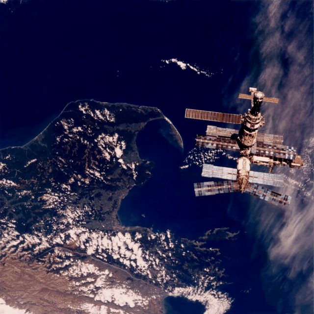
Posted on 03/27/2004 3:40:24 AM PST by petuniasevan
Discover the cosmos! Each day a different image or photograph of our fascinating universe is featured, along with a brief explanation written by a professional astronomer.
2004 March 27
Explanation: This dream-like image of Mir was recorded by astronauts as the Space Shuttle Atlantis approached the Russian space station prior to docking during the STS-76 mission. Sporting spindly appendages and solar panels, Mir resembles a whimsical flying insect hovering about 350 kilometers above New Zealand's South Island and the city of Nelson near Cook Strait. In late March 1996, Atlantis shuttled astronaut Shannon W. Lucid to Mir for a five month visit, increasing Mir's occupancy from 2 to 3. It returned to pick Lucid up and drop off astronaut John Blaha during the STS-79 mission in August of that year. Since becoming operational in 1986, Mir has been visited by over 100 spacefarers from the nations of planet Earth including, Russia, the United States, Great Britain, Germany, France, Japan, Austria, Kazakhstan and Slovakia. After joint Shuttle-Mir training missions in support of the International Space Station, continuous occupation of Mir ended in August 1999. The Mir was deorbited in March 2001.
NASA's Spirit will begin trekking toward hills on its eastern horizon in the next few days, entering a new phase of the rover's exploration of Mars just before its prime three-month mission ends and its extended mission begins, rover team members said today.
 This image shows the rocky road the Spirit rover will travel to reach its ultimate destination - the Columbia Hills. The hills, seen here in the background, are located 2.3 kilometers (1.4 miles) away in the southeast direction. Credit: NASA/JPL Download a larger image here |
Older rocks may hold evidence of an ancient body of water thought to have once filled Gusev Crater. Spirit landed inside that 150-kilometer-wide (95-mile-wide) crater 12 weeks ago, and the rover's main task is to find geological clues about whether the region ever had a wet environment. Spirit has spent much of its time since landing driving toward a 200-meter-wide (660-foot-wide) crater nicknamed "Bonneville." Rover scientists had anticipated that the impact that excavated Bonneville might have ejected rocks old enough to hold clues about whether Gusev held water.
"The ejecta from Bonneville didn't get excavated from deep enough to get below the volcanic layer," Arvidson said. So, after finishing an examination of a light-colored rock on the crater's rim, Spirit will head for the hills.
NASA's Jet Propulsion Laboratory, Pasadena, Calif., built each of the two Mars Exploration Rovers for a prime mission of 90 martian days of operation. Both rovers are healthy and could operate for several additional months, said JPL's Matt Wallace, mission manager. A martian day, or sol, lasts about 40 minutes longer than an Earth day, and Spirit's 82nd sol began on Friday. "Spirit will start driving toward the hills on sol 84 or a little after that," Wallace said.
Scientists have examined the terrain between Bonneville Crater and Columbia Hills in photographs taken from orbit by NASA's Mars Global Surveyor and found several features to inspect along the route. These include some small craters and a dark streak apparently left by a whirlwind that removed dust.
 This map shows thSpirit's past and future routes across the Gusev Crater floor. The solid red line shows where the rover has traveled so far, from lander to the rim of the large crater dubbed "Bonneville." The dotted red line indicates proposed future paths to the Columbia Hills. Credit: NASA/JPL/MSSS/New Mexico Museum of Natural History and Science Download a larger image here |
With stops for "traverse science" along the way, the trip of about 2.3 kilometers (1.3 miles) to the near edge of Columbia Hills will probably take 60 to 90 sols, Arvidson said.
Beginning next week and continuing into the extended mission, Spirit's controllers will switch from working on Mars time - with schedules set to coincide with day or night at Gusev crater - to an Earth time schedule easier to maintain for the long haul. The Opportunity team will shift the following week, Wallace said.
Opportunity is also at the start of a trek. This week, it climbed out of the small impact crater informally named "Eagle Crater" that it had been examining since it landed nine weeks ago. Rocks in an outcrop within the crater have provided evidence that the site was once under flowing water. In coming weeks, Opportunity will drive about 750 meters (nearly half a mile) to a crater nicknamed "Endurance," where scientists hope to find and examine a thicker set of bedrock layers to learn more about the duration of the region's wet history.
Before leaving Eagle Crater, Opportunity inspected the soil at five sites in the opposite half of the crater from the outcrop. The target patches show a diversity of particle sizes and shapes on the surface. "We're seeing the effects of differences in wind speed," said Bethany Ehlmann, a science team collaborator from the University of Washington, St. Louis. In some patches more than others, winds have removed small particles and left large particles behind, she said.
Spherical gray particles that have been fancifully called blueberries are plentiful in some soil patches higher on the inner slope of the crater than near the center of the crater. A reading by Opportunity's Moessbauer spectrometer on one of the higher patches found the highest concentration of hematite seen so far in the mission, reported Dr. Goestar Klingelhoefer of the University of Mainz, Germany. He is the lead scientist for that instrument, which is used for identifying iron-containing minerals. The type of hematite Opportunity has been finding usually forms on Earth under wet environmental conditions.
JPL, a division of the California Institute of Technology in Pasadena, manages the Mars Exploration Rover project for NASA's Office of Space Science, Washington, D.C.

YES! You too can be added to the APOD PING list! Just ask!
Disclaimer: Opinions posted on Free Republic are those of the individual posters and do not necessarily represent the opinion of Free Republic or its management. All materials posted herein are protected by copyright law and the exemption for fair use of copyrighted works.