Posted on 08/10/2021 9:48:04 AM PDT by blam

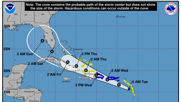
The National Hurricane Center is monitoring Potential Tropical Cyclone 6, which is set to become Tropical Storm Fred as early as Tuesday.
As of 0500 ET, Potential Tropical Cyclone 6 is 65 miles southwest of Guadeloupe, an island group in the southern Caribbean Sea. NHC states the storm has a 90% chance of developing into a tropical storm over the next 48 hours.
WFTV Orlando’s Meteorologist Brian Shields expects Potential Tropical Cyclone 6 to be upgraded to Tropical Storm Fred “soon.” He expects the storm will soon “impact Puerto Rico as a tropical storm, and then move into the Dominican Republic.”
BECOMING FRED: This will become Fred soon. It will impact Puerto Rico as a tropical storm, and then move into the Dominican Republic. If it survives land, there could be a tropical storm just south of us by late week. I’m tracking what all this means, on Channel 9 right now! pic.twitter.com/5Y0bN37umn
— Brian Shields, WFTV (@BrianWFTV) August 10, 2021
By the weekend, Shields expects the storm could impact the South Florida area. NHC’s forecast cone shows the storm could begin to produce tropical storm conditions in South Florida as early as Saturday morning.
The National Weather Service said Monday that South Florida could see “widespread and heavy rain” over the weekend. The impact of the storm is still unclear.
Aug 9th at 5pm – Potential Tropical Cyclone Six is forecast to become a Tropical Storm later tonight. While exact impacts for South Florida remain uncertain at this time, widespread & heavy rain will be possible across South Florida late this week into this weekend. Stay tuned! pic.twitter.com/J4t50HZxLA
— NWS Miami (@NWSMiami) August 9, 2021
A Tropical Storm Warning is in effect for:
◾Puerto Rico, including Culebra and Vieques
◾U.S. Virgin Islands
◾Dominican Republic on the south coast from Punta Palenque
◾eastward and on the north coast from Cabo Frances Viejo eastward
A Tropical Storm Watch is in effect for:
◾Martinique and Guadeloupe
◾Dominica
◾Saba and St. Eustatius
◾Dominican Republic on the north coast from Cabo Frances Viejo to
◾the Dominican Republic/Haiti border
◾Haiti from the northern border with the Dominican Republic to
◾Gonaives ◾Turks and Caicos Islands
◾Southeastern Bahamas
Last week, the National Oceanic and Atmospheric Administration upgraded the number of named storms this year to 21 from its prior forecast of 15 in May.
Statistically, the busiest part of the hurricane season begins on Aug. 20 and lasts through Sept. 10.

We’re all gonna die.
Bttt
And if this happens on election day 2024? Hurricane season lasts through November. Red states along the coast/gulf coast. The rats won’t need covid. We need to think ahead.
Hurricanes, brought to you by ‘global warming’. ;)
There goes the fishing tournament...
I know right?
Its not supposed to get any stronger than 35 mph even when it gets into the gulf.
SMH
This one could be a problem if it ends up in the central GOM
Keep an eye on it
Everybody in Florida will be dead from COVID by then anyway so why worry....sarc
Oh Noes!!! A thunderstorm.
But at least we’ll be vaccinated!...................
The fish ain’t goin’ nowhere....................
“The fish ain’t goin’ nowhere....................”
Ha, but the tournament can be cancelled. Fingers crossed it’s not.
rainy week end I suppose:
https://www.nhc.noaa.gov/refresh/graphics_at1+shtml/145238.shtml?gm_track#contents
What tourney
Sounds like the government should be making extra patrols to find any refugee boats or rafts leaving Cuba and send them back right now, before the storm hits. It would be bad optics to have bodies washing ashore after the weather clears.
Destin’s Fishing Rodeo isn’t until October, so there’s that..............
Disclaimer: Opinions posted on Free Republic are those of the individual posters and do not necessarily represent the opinion of Free Republic or its management. All materials posted herein are protected by copyright law and the exemption for fair use of copyrighted works.