Skip to comments.
FRIGHTENING: China Admits Three Gorges Dam Moved, Ignores Numerous Prior Reports and Says It Just Happened Last Weekend
Gateway Pundit ^
| 07/22/2020
| Joe Hoft
Posted on 07/22/2020 5:45:02 PM PDT by SeekAndFind

China finally admits Its Three Gorges Dam has ‘deformed slightly’ but claims it happened over the weekend, ignoring reports this happened long ago.
The Asian Times reported yesterday:
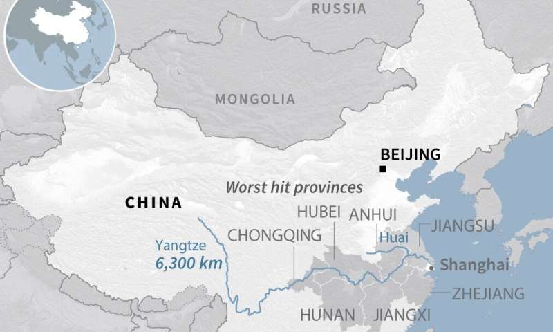
In a rare revelation, Beijing has admitted that its 2.4-kilometer Three Gorges Dam spanning the Yangtze River in Hubei province “deformed slightly” after record flooding.
The official Xinhua News Agency quoted the operator of the the world’s largest hydroelectric gravity dam as saying that some nonstructural, peripheral parts of the dam had buckled.
The dam was a pet project of the late Premier Li Peng and a monumental pride of the nation when it blocked and diverted Asia’s largest river in 1997.
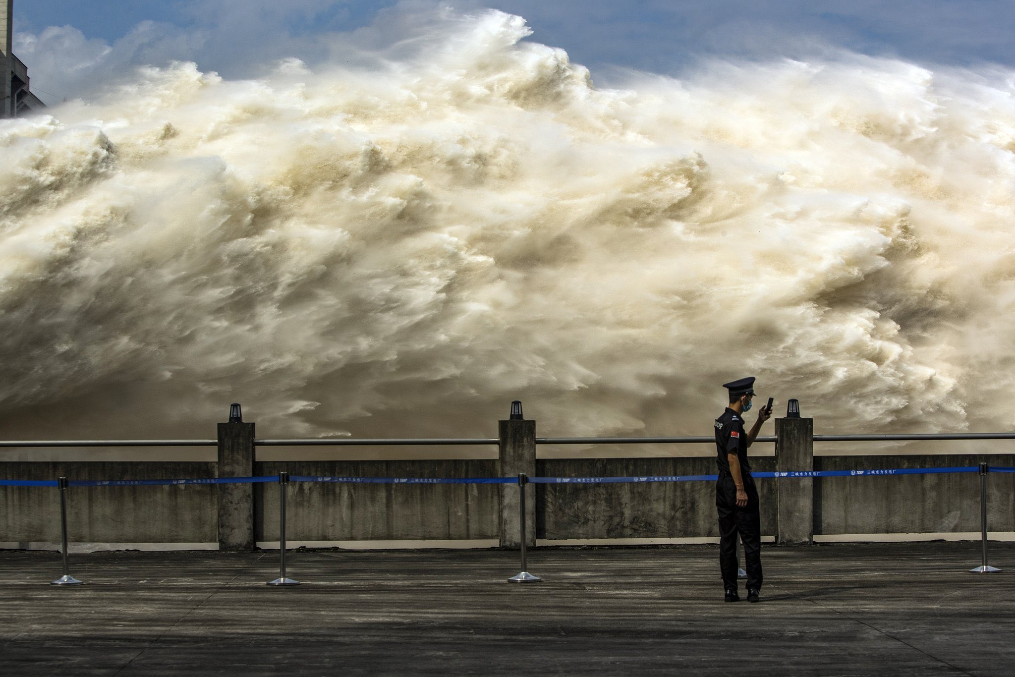
The deformation occurred last Saturday when the flood from western provinces including Sichuan and Chongqing along the upper reaches of the Yangtze River peaked at a record-setting 61,000 cubic meters per second, according to China Three Gorges Corporation, a state-owned enterprise that manages the dam and the sprawling power plant underneath it.
The company noted that parts of the dam had “deformed slightly,” displacing some external structures, and seepage into the main outlet walls had also been reported throughout the 18 hours on Saturday and Sunday when water was discharged though its outlets.
One week ago the Asian Review reported:
…Zhang Jianping, an activist in Jiangsu, is skeptical.
“With hindsight, I think that all those experts who opposed the buildings of the Three Gorges were right,” Zhang said on Radio Free Asia. “Since it was built, it has never played a role in preventing flooding or droughts, like we thought it would back then.”
Despite protests by residents and environmentalists, the Three Gorges Dam was completed in 2006 after a 12-year build. Millions were displaced as an area of about 600 kilometers was submerged to create the world’s largest dam and hydroelectricity facilities.
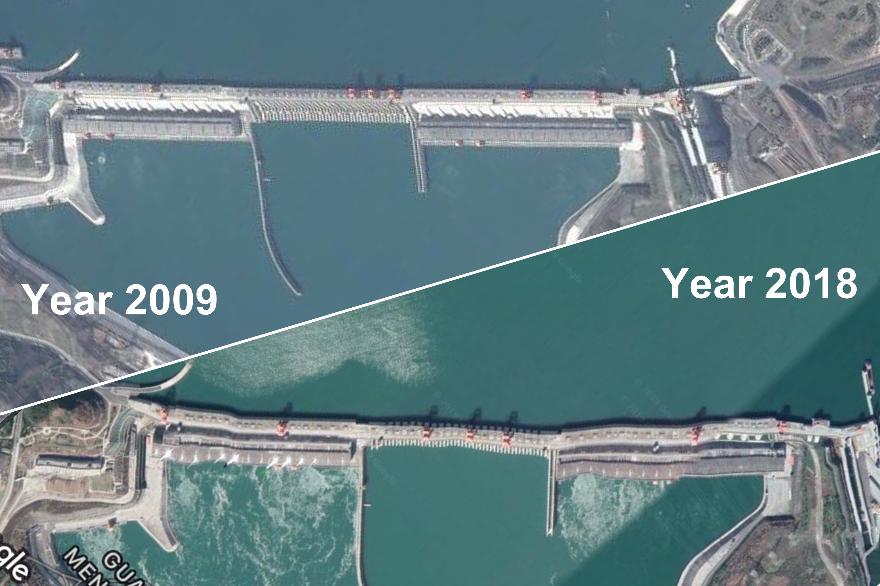
However, two weeks ago we reported China’s massive Three Gorges Dam is at risk of blowing, putting 400 million people at risk. The problem is that China once claimed the dam would withstand a 10,000 year flood, then a 1,000 year flood and now only a 100 year flood. Then in 2018 it was reported online that pictures show that the Three Gorges Dam has moved:
CLICK ABOVE ARTICLE LINK FOR THE VIDEO
An expert on the region’s food supply, Geoff Quartermaine Bastin, provided this analysis regarding the impact on the world’s food supply should the massive dam break:
The collapse of the TGD would destroy all the cropland and livestock downstream, destroy major cities such as Wuhan and could threaten Shanghai. It would affect the Grand Canal systems and so spill over into the Yellow River Region. I’m not going to quantify the damage, it’s very clear that the collapse would be catastrophic.
But not just to China. The country already is a net food importer. Without soybeans from Brazil and the USA and wheat from Australia and Europe and the US, China cannot feed its livestock let alone its human population. The collapse of the TGD would perhaps be the single largest disaster that could affect the world’s food security because aside from the immediate disaster there would be enormous upward pressure on food prices, putting essential staples out of reach of hundreds of millions of people outside China.
The point here is that anyone concerned about food anywhere should want to think through what they might do if the TGD failed.
The official China position is that the Three Gorges Dam moved this past weekend. It moved, but last weekend is at least two weeks after the dam’s movement first occurred.
TOPICS: Society; Weather
KEYWORDS: breakbabybreak; ccp; china; dam; flooding; foodsupply; foodsupplypanic; photoshoporama; threegorgesdam; yangtze; yangtzeriver
Navigation: use the links below to view more comments.
first previous 1-20, 21-40, 41-60, 61-80 ... 121-129 next last
To: SeekAndFind
Elastic reinforced concrete structure design?
21
posted on
07/22/2020 5:58:07 PM PDT
by
shotgun
To: SeekAndFind
if it breaks,,it destroys wuhan? the place where the wuhu flu came from?how convenient
To: Vision
IIRC, the Yangtze River cuts through Wuhan, right in the path of the flood zone. Unless I have the river flow backwards.
23
posted on
07/22/2020 6:00:39 PM PDT
by
Viking2002
("If a really stupid person becomes senile......how can you tell?" - George Carlin)
To: Old Yeller
When the levee breaks mama you got to move
24
posted on
07/22/2020 6:01:40 PM PDT
by
dfwgator
(Endut! Hoch Hech!)
To: metmom
To: Viking2002; Vision
To: SeekAndFind
To: Pox
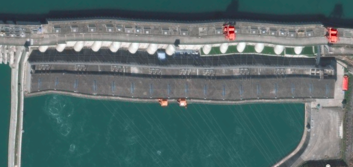
The latest image on Apple Maps shows “distortion” ... and the overhead power lines are completely straight. I don’t know when that image was taken, but the straight power lines indicates the image is not optically distorted. (Google Earth image from 2018 shows distortion on the power lines as well, indicating only optical distortion - not physical.)
28
posted on
07/22/2020 6:03:19 PM PDT
by
ctdonath2
(Interesting how those so interested in workERS are so disinterested in workING.)
To: BenLurkin
There’s more water coming in than the dam is capable of controlled release. Enormous storms, and not enough early release.
They’re already causing damage downstream by opening the floodgates wide open. Unfortunately for the dam, the floodgates aren’t big enough.
29
posted on
07/22/2020 6:05:06 PM PDT
by
ctdonath2
(Interesting how those so interested in workERS are so disinterested in workING.)
To: steve86
Current image on Apple Maps shows the straight structures (power lines) are straight. Very bad sign.
(Contrast with older pictures, where the power lines were distorted similar to the apparent dam distortion.)
30
posted on
07/22/2020 6:06:27 PM PDT
by
ctdonath2
(Interesting how those so interested in workERS are so disinterested in workING.)
To: SeekAndFind; Vision
All that hydraulic pressure is gonna turn Wuhan into a mud flat.
31
posted on
07/22/2020 6:07:14 PM PDT
by
Viking2002
("If a really stupid person becomes senile......how can you tell?" - George Carlin)
To: tired&retired
Whoa! Never thought of that. I guess the CCP didn't either.
400 million people without food, water, or power stumbling around an irradiated swamp. How many plants? Are we talking about meltdowns?
32
posted on
07/22/2020 6:07:21 PM PDT
by
Former Proud Canadian
(Islam---At war with Western Civilization for 1400 years)
To: SeekAndFind
Concrete does not bend well. It is, however, very good at cracking!
33
posted on
07/22/2020 6:07:35 PM PDT
by
Nateman
To: BenLurkin
"can’t they just release water and lesson the pressure?"
They have been releasing water, to slow the rise behind the dam, but they have to balance it against the flood conditions that already exist down river. They get the weather forecast for the upcoming rain, and model the buildup and runoff and such.
Bottom Line: Even though they have been releasing a flood downstream, the water still built up to a record level behind the dam. Once in a hundred year rains.
They reported just this last weekend that the flow rate peaked on Saturday night. Hope the rain lets up.
Releasing excess water at Three Gorges Dam last week:
34
posted on
07/22/2020 6:07:46 PM PDT
by
BeauBo
To: dfwgator
If you’re thinking “when the levee breaks mama you got to move” you gots to move NOW.
I’ve pointedly told my kids “never live in an area that could possibly be flooded.” Chose my homes that way, based on an offhand comment from my father “if we’re ever flooded, Syracuse would be under 900 feet of water.”
35
posted on
07/22/2020 6:08:20 PM PDT
by
ctdonath2
(Interesting how those so interested in workERS are so disinterested in workING.)
To: ctdonath2
and seepage into the main outlet walls had also been reported throughout the 18 hours on Saturday and Sunday when water was discharged though its outlets.
This doesn't sound good.
36
posted on
07/22/2020 6:10:12 PM PDT
by
Pox
(Eff You China. Buy American!)
To: edwinland
37
posted on
07/22/2020 6:11:47 PM PDT
by
ctdonath2
(Interesting how those so interested in workERS are so disinterested in workING.)
To: ctdonath2; edwinland
Posting the image that ctdonath2 linked in post #37:
38
posted on
07/22/2020 6:18:42 PM PDT
by
BeauBo
To: ctdonath2
I’m going to take the other side on this one. I tried putting the side of a piece of paper against the power lines next to the biggest deformity and in fact they don’t seem straight. And since they are at an almost 90 degree angle to the direction of the deformity, I would expect them to be only very slightly deformed by warping the dam perpendicular to its run. I also find it a bit suspicious that the greatest deformity occurs in a place where there’s no power lines.
Also, I think that if structures that large shift even a half inch, which you would never even notice without a laser measure, they would be severely structurally unsound. This photo suggests tens of feet of deformation.
Maybe it’s possible but I’m pretty doubtful.
To: ctdonath2
Well, just blow a big hole in the dam like right next to the floodgate and make a new floodgate that way.
That would let some water out, wouldn’t it?
40
posted on
07/22/2020 6:20:48 PM PDT
by
OKSooner
(Saint Nicholas is a real Christian Saint from the 3rd and 4th centuries. John Durham does not exist.)
Navigation: use the links below to view more comments.
first previous 1-20, 21-40, 41-60, 61-80 ... 121-129 next last
Disclaimer:
Opinions posted on Free Republic are those of the individual
posters and do not necessarily represent the opinion of Free Republic or its
management. All materials posted herein are protected by copyright law and the
exemption for fair use of copyrighted works.
FreeRepublic.com is powered by software copyright 2000-2008 John Robinson
