Thanks TXnMA.
Posted on 06/02/2016 6:44:29 PM PDT by 2ndDivisionVet
Jean-Baptiste Chevance senses that we’re closing in on our target. Paused in a jungle clearing in northwestern Cambodia, the French archaeologist studies his GPS and mops the sweat from his forehead with a bandanna. The temperature is pushing 95, and the equatorial sun beats down through the forest canopy. For two hours, Chevance, known to everyone as JB, has been leading me, along with a two-man Cambodian research team, on a grueling trek. We’ve ripped our arms and faces on six-foot shrubs studded with thorns, been savaged by red biting ants, and stumbled over vines that stretch at ankle height across the forest floor. Chevance checks the coordinates. “You can see that the vegetation here is very green, and the plants are different from the ones we have seen,” he says. “That’s an indication of a permanent water source.”
Seconds later, as if on cue, the ground beneath our feet gives way, and we sink into a three-foot-deep muddy pool. Chevance, a lanky 41-year-old dressed in olive drab and toting a black backpack, smiles triumphantly. We are quite possibly the first human beings to set foot in this square-shaped, man-made reservoir in more than 1,000 years. Yet this isn’t merely an overgrown pond we’ve stumbled into. It’s proof of an advanced engineering system that propelled and sustained a vanished civilization....
(Excerpt) Read more at smithsonianmag.com ...
I remember reading in “My Weekly Reader” when I was around 5th grade (1957) about the lost city of Ankgor Wat. It fascinated me that such a huge ruin could be lost in the jungle.
Of course I suspect it wasn’t lost at all but it did make for an interesting story.
***We’ve ripped our arms and faces on six-foot shrubs studded with thorns, been savaged by red biting ants, and stumbled over vines that stretch at ankle height across the forest floor.***
Typical summer day in the Ozarks. Oh wait!
Heads up! This could be a Big One for archaeology...
Absolutely. The first time we went to Ankor it was touristed but not so much. The second time it was literally crawling with people, many of whom didn’t pay any respect to the preservation of the temple or the interests of their fellow tourists. However, I’d go again if health permitted.
It was the subject of my first-ever history essay. I was just 12. but the images I saw of the ruins still haunt my memories.
Placemark for this one too
Very interesting.
I recently discovered a LiDAR database that covers almost all of my (Northeastern Texas) area of responsibility and interest.
The dataset's point spacing is marginal, (only 2.2 points/meter) which is useless for viewing small, discrete objects, but is sufficient -- with appropriate spatial (matrix convolution) filtering -- to distinguish and map linear features like trails, roads and abandoned railbeds.
We have just added LiDAR to our toolkit for our multi-year, multi-county project of mapping the early immigration route called, "Trammel's Trace".
In 1813, Nicholas Trammell began on the west bank of the Red River at its "Great Bend", (where I-30 now crosses it) and, effectively, extended the "Great Southwest Immigration Trail" -- that crossed Arkansas diagonally -- into Texas.
In Western Cass County, Texas -- at what we call the "Y" -- he joined his new Trace with the pre-existing N-S "Spanish Trace", and then improved that route southward to its intersection with the old Spanish "El Camino Real" to San Antonio -- just west of Nacogdoches, Texas.
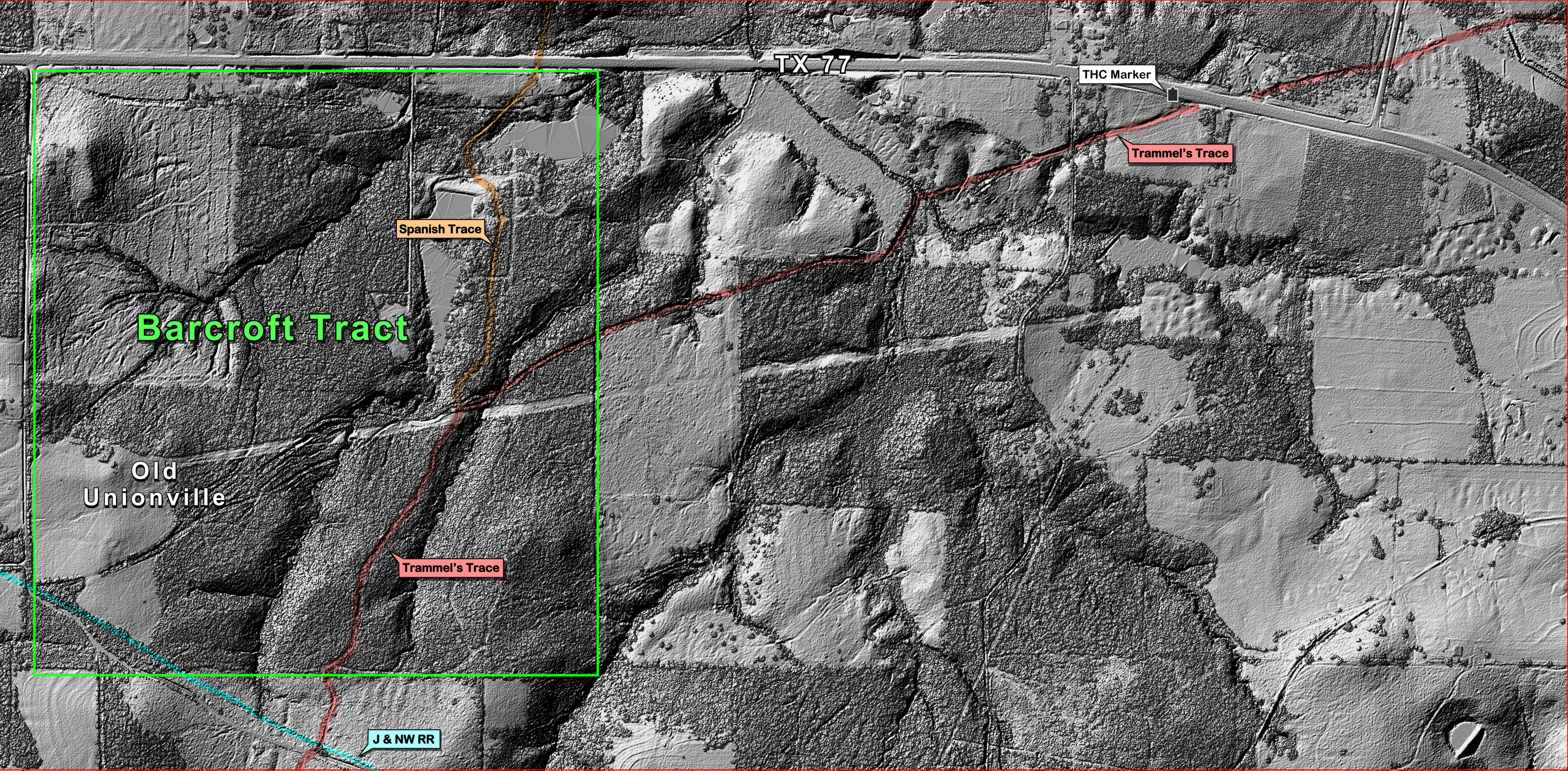
I selected the Cass County area including the "Y" where Trammell joined his Trace with the Spanish Trace as the test site" for evauating the LiDAR dataset:
The post-processed "Bare Ground" LiDAR image revealed a plethora of trails, ruts, etc.
This "annotated" version of the Bare Ground" image clearly shows both Traces -- and the "Y" where they join:
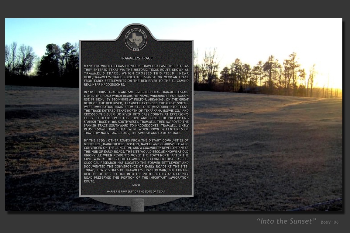
And -- it also shows the site of this historical marker -- at the only known site where Trammel's Trace is still visible from a State highway:
And, finally -- with the foliage cover not subtracted -- it is evident that foliage is no impediment to detecting and mapping the Trace with LiDAR.
In fact, the area surrounded the "Y" intersection is totally overgrown in dense sweetgum brush -- so dense that you can't even walk through it, much less see or follow old, faint ruts.
As expected, travelers on the Traces spread out to the west of the "Y" to form a campground that eventually became the townsite of "Old Unionville". Yet -- with LiDAR -- that (predicted) fanout of ruts westward from the "Y" is still clearly visible.
~~~~~~~~~
Yep, LiDAR data is extremely effective for mapping historic routes -- but, it also is extremely expen$ive!
.-) Anyone got a $$$pare hundred grand lying around -- so we can obtain the data to finish mapping those important (but, rapidly-vanishing) historic immigration routes? '-)
Thanks TXnMA.

Disclaimer: Opinions posted on Free Republic are those of the individual posters and do not necessarily represent the opinion of Free Republic or its management. All materials posted herein are protected by copyright law and the exemption for fair use of copyrighted works.
