Posted on 10/14/2026 9:38:56 AM PDT by yesthatjallen
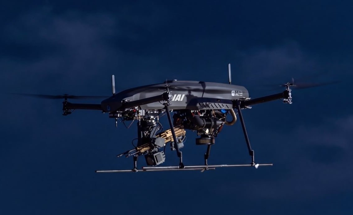
ISRAEL, — Israel Aerospace Industries (IAI) and U.S.-based firearms manufacturer SIG SAUER have completed live-fire testing of the FIRE STORM 250, a vertical takeoff and landing (VTOL) drone armed with an M250 light machine gun. The results were announced during the Association of the United States Army (AUSA) 2026 annual meeting in Washington, D.C. The trials took place in Israel ahead of the exhibition. The drone was first publicly presented at AUSA in 2025.
During the test, the drone hovered over a simulated battlefield, used its onboard camera to identify targets and engaged them in single-shot and semi-automatic firing modes. Testing at different altitudes and ranges assessed firing accuracy, stability and integrated safety features.
Apus 60-Based Drone with Three-Hour Endurance
The FIRE STORM 250 is based on IAI’s Apus 60 VTOL tactical unmanned aircraft and uses a multi-fuel internal-combustion engine. It can remain airborne for up to three hours while carrying 200 rounds of ammunition and can be refuelled in the field, avoiding battery-charging delays. Its VTOL design allows launch and recovery from forward positions without runways or dedicated aviation infrastructure.
SNIP
(Excerpt) Read more at thedefensenews.com ...
Will this be part of Amazon’s new drone delivery system?
Yes, in GAZA.
Maybe in the Donbass.
There is an episode in third season of Lioness. Where they are on the battlefield in Ukraine. There is a swarm of drones. They would fly into them and blow up on impact.
This is the next step in that evolution.
There are real video of drone swarms in Ukraine overwhelming a Russian location (and probably vice versa) out there. It’s truly horrifying. Like being attacked by exploding insects.
Made me go read the back pages of the Bible.
———-
It is the same thing; both “modes” are one single trigger pull, one shot.
….and when AI starts taking control of them as suggested in another thread, Judgement Day gets a little closer to reality.
And without GPS, I expect these are worthless.
(I still want one, though. ;-)

I was a CTT in the US Navy from 1988-1992. I did RF intercept on an IAI drone in 1991 at Fort Huachuca, AZ for a week. Pretty cool, actually.
The 6.8×51mm cartridge is going to have a very short lifespan, at least in the 80,000psi configuration, and the 80,000psi is the only reason it has for existing.
If he meant automatic firer, how long will 200 rounds last.
GPS is needed for long distance strike drones, battlefield drones only need AI edge processing to pick targets and engage them.
Amateur sci guys have already programmed the AI to seek out humans, seek out specific types of humans and using face recognition seek out an individual human. With gait recognition which is as unique as a fingerprint to every person you can also seek out a human who is wearing facial coverings too.
Also quantum magnetics is going to replace GPS on every battlefield along with quantum gravimetrics. The earth has unique magnetic fingerprint and gravity as well. It’s good enough for XX meters it’s classified how good but it beats first gen GPS by a good margine, more than enough for the AI edge processing to pick the target out of the multispectral imaging which we know AI can hit CM level targets as in fly down a vent or into a specific window or down a tank hatch.
It’s not coming it’s already here. QM and QG are in the shrink this down to MEMS chip size so it fits on drones not just full sized aircraft and submarines. It’s when not if and with Starshield doing PNT for sure they embed a time of flight sync frame which with 4 or more 30kw+ Starshield birds blasting PNT signals that cannot be jammed from below you must be in the beam path from above and the birds are moving at 7+km per second across the sky with 40-50 visible at any point on earth. Yeah lots of things going in the background. You can look up how some people have used Starlink the city version to do time of flight positioning then add in a sync flag on purpose yeah GPS is 20th century tech the battlefield has other means now.
Thank you for the reply! That is very interesting data, especially about the QM and QG.
If you happen to know, how can accurate “maps” be attained? Can data be gathered from space, or by fly-over, or do you need ground presence?
It is interesting how the face of warfare changes, too. The old art of camouflage may come back into style. Also, older AWACS planes may return to use for overhead jamming.
Disclaimer: Opinions posted on Free Republic are those of the individual posters and do not necessarily represent the opinion of Free Republic or its management. All materials posted herein are protected by copyright law and the exemption for fair use of copyrighted works.