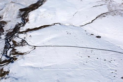
The outline of the old Roman camp at Malham in the Dales
Posted on 04/05/2022 8:32:17 PM PDT by SunkenCiv
Taken over the past 100 years, they can be compared to modern images to show changes in the landscape as well as archaeology hidden beneath the surface and only visible from the air.
The archive includes the outline of the Roman military camp at Malham in the Yorkshire Dales, coastal erosion near Kilnsea, the East Hecla steelworks which were demolished to make way for Meadowhall, the foundations of a World War One camp in North Yorkshire and images taken in World War Two of defences such as barrage balloons and a fake airfield.
Over 400,000 images from 1919 to the present day have been added to the tool, covering nearly 30 per cent of England.
Historic England chief executive Duncan Wilson said: “I am delighted that our new online tool will allow people to access easily our wonderful collection of aerial images and enjoy the historic photography that our team uses every day to unlock the mysteries of England’s past.”
A layer of snow helps to pick out the earthwork of a Roman camp in the hills above Malham in the Yorkshire Dales. This type of camp was built by the Roman army when they were on manoeuvres.
(Excerpt) Read more at yorkshirepost.co.uk ...
There was this one more Roman related article, so...
Cool. I spent 1.5 years working in mostly rural East Anglia in the early ‘90’s. I’m going to check out the places I knew.
Eh, they haven’t exactly made the files user friendly.
This is the direct link to the Historic England search page:
https://historicengland.org.uk/images-books/archive/collections/aerial-photos/
Disclaimer: Opinions posted on Free Republic are those of the individual posters and do not necessarily represent the opinion of Free Republic or its management. All materials posted herein are protected by copyright law and the exemption for fair use of copyrighted works.