Free Republic
Browse · Search
General/Chat
Topics · Post Article

To: 1_Rain_Drop; buffaloguy; bitt; ransomnote; bagster; KitJ
1_Rain_Drop, you ask some good questions -- most of which I answered long ago, by doing "OHI" (OverHeadImagery) analysis -- covering the span of time from 2002 -- to last week's drone flights.

I'm putting together a time-sequence of the tunnel & underground room development that makes it very clear how things developed.

bitt, I said I wasn't going to publish my overall tunnel plan until it's ready -- but this D R A F T already explains a lot:


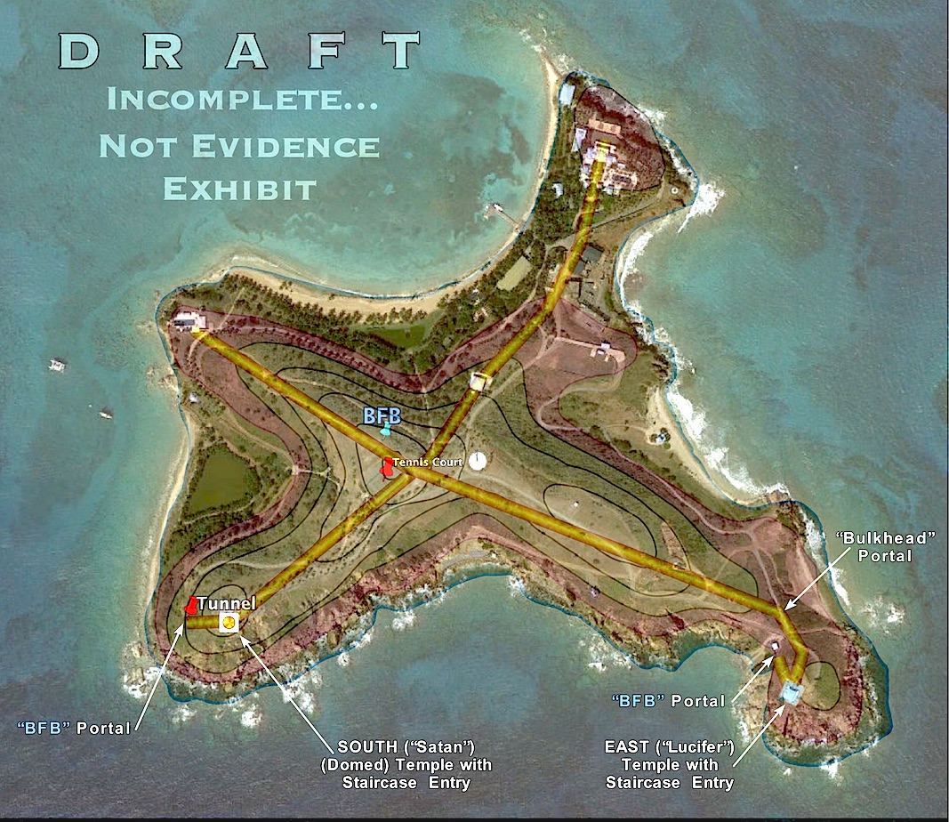
It still needs a LOT of work (i.e. the "tunnel network" needs to move down in the layer stack -- beneath the contour lines,etc...) I work on it as I have time not devoted to "critical path" items...

(ALL: This is still a rough DRAFT, Please DO NOT SHARE outside the Q thread!)

~~~~~~~~~~~

One of the critical (and most visible) aspects of digging tunnels is "spoil dirt" disposal. Instead of being obvious and piling it up like the Iranians (and other bad actors) do, Epstein's crew used it -- anywhere they needed construction dirt (roads, etc.)

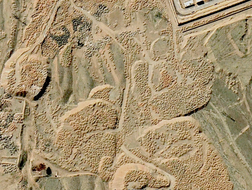
(Yep, I've mapped the spoil disposal area on LSJI...)

BUT, 1_Rain_Drop et al, "Pedo Hill? wasn't "built up", per se... Look closely at the contour lines: that originally was a 148-foot tall, rounded-top hill, but E cut off the top -- and spread spoil dirt all across the flat "plateau" he'd made. Now the entire top of the hill is flat. Here's a BobCat making it so:

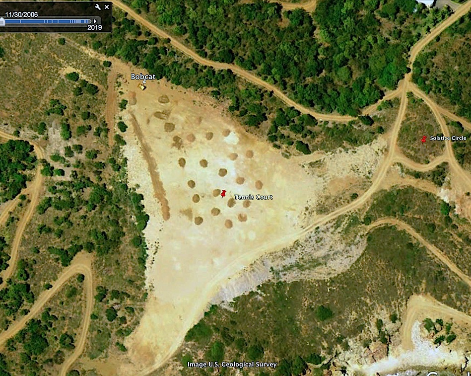
Until it was updated recently, GE's (Google Earth/Maps) "DEM (Digital Elevation Model) -- the elevation "grid" or "mesh" over which images are "draped" to give the terrain "3-D 'depth'" -- still thought that was a 148-foot tall, rounded-top hill. That meant anything flat (like a tennis court) was drawn curved (moreso if you had "elevation exaggeration" set high). Google corrected the elevation error in a recent database update...

BTW, the tunnels were built starting before 2002 -- but after luxurious houses, etc. were built...

There are no windmills, but there are big banks of solar cells...

Pyramids? I'm an archaeologist -- but, ya got me on how they relate to tunneling -- and trying to hide it... '-)

~~~~~~~~~~~

Hope this answered some of your questions...

TXnMA
  

P.S. Yeah, I know that I need to put the elevation labels on the contour lines -- It's on the list... '-)

P.P.S "BFB" labels tunnel access points -- typically covered by blue-painted metal boxes -- often where the tunnel boring machine started into the hillside "where the road ends"... (From Q's clue, "Bunker Forest Blue" in Qdrop #1007.).

1,016 posted on 07/17/2019 4:16:26 PM PDT by TXnMA (Remember the Alamo! | Remember Goliad! | REPEAT San Jacinto!!)
[ Post Reply | Private Reply | To 695 | View Replies ]


To: TXnMA

What is beneath the “tennis courts” ??? Right at the axis. I saw a pic today and it looks fake like it’s rolled out to look like a tennis court from satellite.


1,028 posted on 07/17/2019 4:38:01 PM PDT by Steven W.
[ Post Reply | Private Reply | To 1016 | View Replies ]

To: generally
I intended to ping you to #1016...

BTW, if you know anyone else interested in this PedoIsle thing, would you please ping them to #1016 -- and me, too? (I'm trying to put together an "interested parties" list.)

ThanQ! TXnMA
  

1,029 posted on 07/17/2019 4:38:02 PM PDT by TXnMA (Remember the Alamo! | Remember Goliad! | REPEAT San Jacinto!!)
[ Post Reply | Private Reply | To 1016 | View Replies ]

To: TXnMA

Excellent gouge, Tex.

I’m looking forward to more - keep up the great work!


1,058 posted on 07/17/2019 5:30:07 PM PDT by KitJ (Shall not be infringed...)
[ Post Reply | Private Reply | To 1016 | View Replies ]

To: TXnMA

YOW!!! maganificent!


1,167 posted on 07/17/2019 7:31:26 PM PDT by bitt (US intel is there to protect the safety and security of Americans. It is not a political tool.)
[ Post Reply | Private Reply | To 1016 | View Replies ]

To: TXnMA
"1_Rain_Drop, you ask some good questions -- most of which I answered long ago, by doing "OHI" (OverHeadImagery) analysis -- covering the span of time from 2002 -- to last week's drone flights. "

Thanks for the tunnel map & sorry I missed your previous posts. I thought the tunnels would be more complicated. I'll wait for your finished map before I pose any questions/comments.

1,326 posted on 07/18/2019 3:14:42 AM PDT by 1_Rain_Drop
[ Post Reply | Private Reply | To 1016 | View Replies ]

Free Republic
Browse · Search
General/Chat
Topics · Post Article


FreeRepublic, LLC, PO BOX 9771, FRESNO, CA 93794
FreeRepublic.com is powered by software copyright 2000-2008 John Robinson