(this is full sized, but shown at 600 p width)
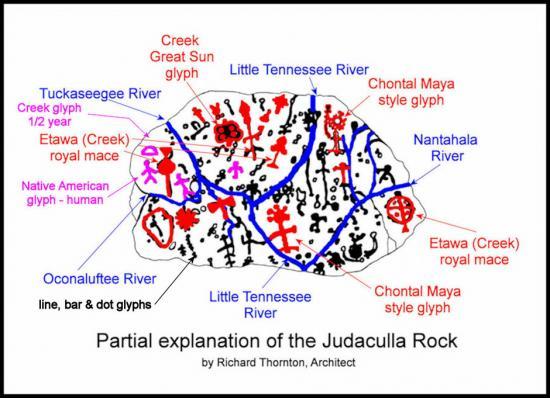
For this 1930s photo, the cryptic markings were filled with chalk. Since this valuable picture was made, the rock has continued to erode, making serious study increasingly difficult. [photo courtesy Jerry Parker]
![For this 1930s photo, the cryptic markings were filled with chalk. Since this valuable picture was made, the rock has continued to erode, making serious study increasingly difficult. [photo courtesy Jerry Parker]](http://shadowboxent.brinkster.net/images4/JudacullaRockPhoto.jpg)
1 posted on
02/15/2015 12:13:47 PM PST by
SunkenCiv
To: SunkenCiv
There`s a 767 flying past the sun in the upper left corner.
3 posted on
02/15/2015 12:19:17 PM PST by
bunkerhill7
(`t find evidence 2000 yrears old- heck I can`t een find my d federal drivers licens efrom 1972.)
To: SunkenCiv
Sounds like they ought to find a way to protect it from the elements.
It’s very pretty, they could sell stuff with those designs on it to raise money to protect it.
4 posted on
02/15/2015 12:20:01 PM PST by
jocon307
(Tell it like it is.)
To: SunkenCiv
“Jackson Pollock was here.”
To: SunkenCiv
That's a map of my old neighborhood ...
See ... six fingered Louie lived with his pigeontoed wife with a dog on main st .. (the house with the smoke comin' from the chimney and an apple tree out front)
Hang a right at the next alley and you come to that fairy's house ( I forget his name ,, charlie or charlene or something) on the right
Across the street (alley) from the fairy was Sonny's crib .. he liked to garden and always had some crops to raid when we was hungry
Keep goin' a little farther and you'd come to pig's house ... no one EVER knew her name, but she'd do ANYthing if you paid her
If you continued down to the end of the road and looked to your right ... you'd see old man geezer ... just standin' there with an old hat on .. if you looked passed him into the distance, you could make out the corn field he SEEMED to be standing beside ...
Which shows t' go ya .... an old southerm gentleman is always outstanding in his field.
7 posted on
02/15/2015 12:26:23 PM PST by
knarf
(I say things that are true ... I have no proof ... but, they're true)
To: SunkenCiv
Don’t be silly! It was left by the Muslims.
10 posted on
02/15/2015 12:41:22 PM PST by
Dr. Bogus Pachysandra
(Don't touch that thing Don't let anybody touch that thing!I'm a Doctor and I won't touch that thing!)
To: SunkenCiv
If it has eroded as much as the article indicated since 1930, that would indicate that it’s not all that old.
11 posted on
02/15/2015 12:50:38 PM PST by
JimSEA
To: SunkenCiv
Great post.
I spent a large part of my younger years near Asheville and in western South Carolina.
Can't believe I never heard about this before!
As I recall, some of the earliest dated settlements in North America have been located in eastern South Carolina.
To: SunkenCiv
14 posted on
02/15/2015 1:04:19 PM PST by
UnwashedPeasant
(A slave is one who waits for someone to come and free him.)
To: SunkenCiv
15 posted on
02/15/2015 1:12:58 PM PST by
SWAMPSNIPER
(The Second Amendment, a Matter of Fact, Not A Matter of Opinion)
To: SunkenCiv
So Yves Tanguy was a time traveler?
16 posted on
02/15/2015 1:15:52 PM PST by
Stentor
("The best lack all conviction, while the worst are full of passionate intensity.")
To: SunkenCiv
I would guess a big, flat stone like that would mostly likely have been used as a sacrificial altar, so the markings are probably related to the religion of whoever was using it for that.
To: SunkenCiv
Great, so tell idiots where it is so they can come paint it up like they have Lover’s Leap on US 58 past Stuart. Narcissist nation thinks their stupid initials will be remembered, in the face of such beauty of the valley. Utter nobodies.
25 posted on
02/15/2015 2:11:09 PM PST by
John S Mosby
(Sic Semper Tyrannis)
27 posted on
02/15/2015 2:21:19 PM PST by
deport
To: SunkenCiv
The petroglyphs resemble the ones on a stone discovered on Sweetwater creek...less than a mile from my house. You have posted a thread about it before.
To: SunkenCiv
It's a cookbook!
43 posted on
02/15/2015 5:02:40 PM PST by
Jed Eckert
(Wolverines!!)
To: SunkenCiv
Looking at it, especially the lower right below the long diagonal, it becomes obvious it was inscribed by “The Mad Arab,” Abdul Alhazred.
44 posted on
02/15/2015 5:50:51 PM PST by
ApplegateRanch
(Love me, love my guns!©)
To: onedoug; stylecouncilor
FreeRepublic.com is powered by software copyright 2000-2008 John Robinson
![For this 1930s photo, the cryptic markings were filled with chalk. Since this valuable picture was made, the rock has continued to erode, making serious study increasingly difficult. [photo courtesy Jerry Parker]](http://shadowboxent.brinkster.net/images4/JudacullaRockPhoto.jpg)


