Skip to comments.
Astounding formations, Bolivia, S. America
Atlantis Bolivia ^
Posted on 04/03/2011 10:10:25 PM PDT by djf
I was doing some web research on prehistoric formations in South America and hit the above website.
It has possibly hundreds of satellite images of what cannot in any sense be natural glyphs and structures on the grounds surrounding Lake Tititaka.
Here is a sample:
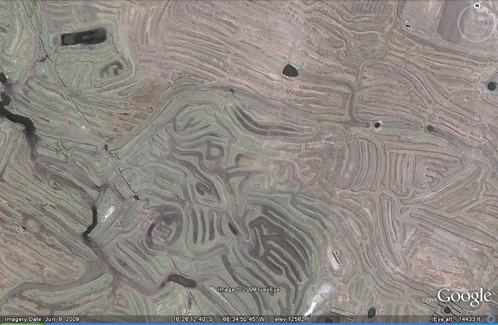
Whoever made these artifices, and at what age/time they were made, remain unknown. Literally hundreds, perhaps thousands of square miles of formations.
I know some FReepers are interested in this subject, it certainly seems to me that it might make a bit of a mockery out of any claims that a couple guys crossed the Bering Strait 8000 years ago and that's what started culture in the Western Hemisphere.
Take a look at the pics... they are truly jaw-dropping!
TOPICS: Agriculture; History; Weird Stuff
KEYWORDS: bolivia; godsgravesglyphs
Navigation: use the links below to view more comments.
first previous 1-20 ... 41-60, 61-80, 81-100, 101-109 next last
To: djf
No language? No culture? No cities? No ceramics? What the heck is this all about? To find that stuff you have to look for it. Until recently academic archaeologists were so stuck on "Clovis first" they simply disregarded work showing there were earlier cultures. It's only recently they've begun to accept the documented 15,000-year-old artifacts at Monte Verde in Chile.
As Blam says, there's a treasure trove in South America for a new generation of open-minded archaeologists/anthropologists who follow true scientific procedures. Consider all the evidence of not only advanced agriculture but sophisticated knowledge of soil chemistry in the jungles of Brazil. The search has just begun.
To: B4Ranch; Flag_This
I have “The HAB Theory” on my bookshelf.
One of the most interesting parts is later in the book when they convene a symposium of sorts to analyze the data and the likelihood that Boardman’s theory (of crustal displacement) is true.
At that time, they start to detail (and there is ALOT of detail) on various reasons about things which simply do not fit into any standard archeological models then taken as the standard. Things like the Piri R’eis map (and there are other maps that show the same), the derivation/migration of basic vegetation/foodstocks, a bunch of other stuff.
I’ll have to dust it off and read that part again to see what I can find...
82
posted on
04/04/2011 7:18:21 PM PDT
by
djf
(Dems and liberals: Let's redefine "marriage". We already redefined "natural born citizen".)
To: B4Ranch
"These days if a person vocalizes anything outside of the accepted and approved thinking they are automatically shunted off the the dark room and labeled as a quack thinker." It's a pretty old story - I can think of several examples in different fields, but the "Clovis first" situation in anthropology immediately comes to mind. For a long time, anyone who didn't conform with that particular theory had a hard way to go.
How does that old quote go?
"Academic politics is the most vicious and bitter form of politics, because the stakes are so low."
83
posted on
04/04/2011 7:22:42 PM PDT
by
Flag_This
(Real presidents don't bow.)
To: blam
Do the shapes of the irrigation pools follow the natural contours of the land or do they have another possibly symbolic purpose?
84
posted on
04/04/2011 7:29:08 PM PDT
by
1010RD
(First, Do No Harm)
To: Fred Nerks
85
posted on
04/04/2011 7:30:04 PM PDT
by
blam
To: djf
"I have “The HAB Theory” on my bookshelf." I wasn't familiar with that book, so I did a quick search - was it written by the same Allan Eckert that wrote "The Frontiersman" and "That Dark and Bloody River?" If so, I've gotta read it.
86
posted on
04/04/2011 7:31:49 PM PDT
by
Flag_This
(Real presidents don't bow.)
To: 1010RD
"Do the shapes of the irrigation pools follow the natural contours of the land or do they have another possibly symbolic purpose?" My guess is that they followed the easiest way possible, in the beginning probably very little planning too.
87
posted on
04/04/2011 7:37:42 PM PDT
by
blam
To: roamer_1
The Bering Sea crossing is bunkum. How is it that civilizations get more sophisticated the further south you go?
88
posted on
04/04/2011 7:42:54 PM PDT
by
1010RD
(First, Do No Harm)
To: DavemiesterP
89
posted on
04/04/2011 7:48:44 PM PDT
by
1010RD
(First, Do No Harm)
To: wendy1946
They look like cast in place poured concrete.
90
posted on
04/04/2011 7:51:12 PM PDT
by
1010RD
(First, Do No Harm)
To: blam
THE PORT OF PUMA PUNKU
Strangely, Tiahuanacu appears to be a seaport (Posnansky, 1945), although the nearest body of water is Lake Titicaca, some 12-15 miles away (the distance depends on the level of the lake). There are several theories about how this happens to be. We will consider only one here.
On the rock cliffs near the piers and warfs of the port area are yellow-white calcareous deposits forming long, straight lines indicating pre-historic water levels. These ancient shorelines are strangely tilted, although they must have once been level. The surrounding area is covered with millions of fossilized sea-shells. It appears, from the tilting of the ancient shoreline striations and the abundant presence of fossilized oceanic flora and fauna, that a tremendous uplift of land has taken place sometime in the ancient past. Geologists estimate that this happened roughly around 100 million years ago; but the data gathered from archeological and astronomical investigations indicate a different story.

Oceanic creatures live to this day in abundance in the salty waters of the lake, indicating that it was once a part of the ocean, although it is now over 2 miles above sea-level. What appears to be the original seashore is strangely tilted, as if a tremendous geological upheaval has taken place.

Huge building blocks thrown about in all directions at the ruins of Puma Punku. (Photo by Holly Ahlberg)
The port of Tiahuanacu, called Puma Punku or "Door of the Puma," is an area filled with enormous stone blocks scattered hither and yon like matchsticks, yet weighing between 100 and 150 tons! One block still in place weighs an estimated 440 tons! One wonders, how these blocks were quarried, how they were transported from the quarries to the building site, and how the builders managed to place such huge blocks so skillfully to form this massive complex of megalithic buildings? And above all, what tremendous forces could have tumbled these gigantic stones over one another as if they were light as driftwood? Archeologists have no answers.
The blocks, many of them weighing upwards of 200 tons, are in some cases held together by large metalic, I-shaped couplers, rather than enterlocking shapes as at Sacsahuaman or at Cuzco. Others were held together by silver rivets. The system used here is reminiscent of that used in the Egyptian ruins on Elephantine Island on the Nile. Most researchers believe that the metal was actually poured into I-shaped slots carved into the rock.
Some of the docks and piers in this area are so large that hundreds of ships could dock comfortably; yet there is nothing "oceanic" near these docks except a prehistoric coastline indicated by chalky deposits of ancient salt water fossils. Lake Titicaca, languishing miles away, is nearly 100 feet lower than the ruined docks. What tremendous geological upheaval has occurred in the last thousand years that could have tumbled these huge stones while heaving the entire altiplano region 2 miles into the sky? None at that recent date. But could a sudden, violent tilt of the axis of the earth occuring some 12,000 years ago have been responsible?
source
91
posted on
04/04/2011 7:53:23 PM PDT
by
Fred Nerks
(FAIR DINKUM!)
To: Fred Nerks
Interesting articles. South America is a continent that I know very little about.
92
posted on
04/04/2011 8:10:38 PM PDT
by
B4Ranch
(Allowing Islam into America is akin to injecting yourself with AIDS to prove how tolerant you are .)
To: Fred Nerks
>>But could a sudden, violent tilt of the axis of the earth occuring some 12,000 years ago have been responsible?<<
Please define ‘sudden, violent’. Are we talking 1/2 second, half hour, day, week, month, year, decade or century?
93
posted on
04/04/2011 8:30:00 PM PDT
by
B4Ranch
(Allowing Islam into America is akin to injecting yourself with AIDS to prove how tolerant you are .)
To: B4Ranch
94
posted on
04/04/2011 8:34:06 PM PDT
by
Fred Nerks
(FAIR DINKUM!)
To: 1010RD
Pouring diorite would be a technical capability beyond our own.
To: djf
To: Fred Nerks
Have you ever seen the damage done by the rainfalls flooding the washes in the desert? A 10 mile wash can alter its path and cut a new one in one single heavy storm.
If a few previous small rain storms have pushed some brush and soil into a bend, partially blocking the original route, when a seriously heavy rainstorn comes down the wash it will cut a new path and maybe a mile later rejoin the original route.
An instantaneous and violent tilt of the axis of the earth would probably cut multiple Grand Canyons. Moving such a massive amount of water over the soft bed of the ocean would rip the silt from the ocean bed doing more damage (creating Grand Canyons) than recent tsunami waves in Japan.
Now if it occurred slowly, say over a decade then the ocean bed would remain in place.
Is that logical to you or doesn’t it fit into a preconceived idea that you have?
97
posted on
04/04/2011 8:55:17 PM PDT
by
B4Ranch
(Allowing Islam into America is akin to injecting yourself with AIDS to prove how tolerant you are .)
To: blam
98
posted on
04/04/2011 9:01:08 PM PDT
by
Fred Nerks
(FAIR DINKUM!)
To: B4Ranch
EARTH IN UPHEAVAL by Immanuel Velikovsky:
...'...Once Tiahuanacu was at the water's edge; then Lake Titicaca was ninety feet higher, as it's old strand line discloses. But this strand line is tilted and in other places it is more than 360 feet above the present level of the lake. There are numerous raised beaches; and stress was put on "the freshness of many of the strandlines and the modern character of such fossils as occur."

Not that I go with the Atlantis-Bolivia scenario...but SOMETHING happened suddenly-instantaenously and with a massive force of energy; even Darwin writes of finding sea shells at 1300 feet elevation, in his private journals.
99
posted on
04/04/2011 9:22:15 PM PDT
by
Fred Nerks
(FAIR DINKUM!)
To: Fred Nerks
Like I said, moving that amount of water in a single day would have cut a sharp walled trench similar to the Grand Canyon. Desert washes do not have gently sloped banks similar to a lake. They look as if they were cut with a giant fire hose.
Is there any sharp walled trench landscape on the edge of Lake Titicaca?
100
posted on
04/04/2011 9:38:13 PM PDT
by
B4Ranch
(Allowing Islam into America is akin to injecting yourself with AIDS to prove how tolerant you are .)
Navigation: use the links below to view more comments.
first previous 1-20 ... 41-60, 61-80, 81-100, 101-109 next last
Disclaimer:
Opinions posted on Free Republic are those of the individual
posters and do not necessarily represent the opinion of Free Republic or its
management. All materials posted herein are protected by copyright law and the
exemption for fair use of copyrighted works.
FreeRepublic.com is powered by software copyright 2000-2008 John Robinson