Skip to comments.
Man spends life researching Lost Colony mystery
The Virginian-Pilot ^
| 17 Oct 2010
| Jeff Hampton
Posted on 10/17/2010 2:55:01 PM PDT by Palter
Sam Sumner retired as a schoolteacher, left his Hawaii home and recently moved to North Carolina, all for the purpose of solving the mystery of the Lost Colony.
The answer lies not in Buxton where experts and amateur sleuths have searched for decades, he says, but at Mackay Island National Wildlife Refuge in Currituck County, a site that leaves experts skeptical.
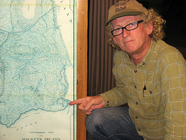
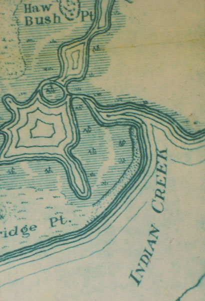
A 1923 map in the lobby of Mackay Island ranger station shows an image on the ground next to the Currituck Sound that looks just like an old drawing of Fort Raleigh.
"I looked at that map and I knew immediately what it was," Sumner said. "I have the evidence on my side. It is up to the archaeological experts to say the image is not a 16th-century fort."
Sumner, 63, has researched one of America's oldest mysteries for 31 years, traveling almost annually from Hawaii to Roanoke Island. He has partnered with a psychic archaeologist; rented underground radar equipment at budget-busting costs; queried experts; researched books, maps and papers; and written reports.
But the most compelling clue is the map.
Sir Walter Raleigh sent 118 colonists to the New World in 1587 to establish a settlement. Led by John White, they landed at what is now Roanoke Island.
In August 1587, White left for England to get supplies, returning in 1590 to find the colony gone. All he found were the letters CRO carved on a tree and CROATOAN carved on a post. The colony possibly split up, one group going south to Buxton on Hatteras Island where the Croatan Indians lived and the other north toward Chesapeake. White wrote that a group was to go 50 miles inland.
"There are two islands 50 miles away," Sumner said. "One is at Hatteras and one is Knotts Island."
The colonists lived there for 20 years, until 1607, when the Powhatan Indians massacred them, according to a history from 1612. That is another strong piece of evidence they were there, Sumner said.
Forts of that day were made of earth piled high after digging a ditch around the perimeter, said Doug Stover, historian at the Fort Raleigh National Historic Site on Roanoke Island.
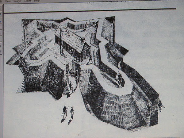
The image on the map has a long nose at one end and is star-shaped at the other, just like the old, undocumented drawing used to show what Fort Raleigh may have looked like.
Sumner could seek help through Fort Raleigh if the evidence is strong enough, Stover said. Mackay Island will not issue Sumner a permit to excavate unless he has backing from a sanctioned archaeologist or group.
It is hard to get backing without more evidence and hard to get more evidence without excavating, Sumner said.
Lost Colony researchers do not give credence to his Mackay Island theory.
"We know of no archaeological evidence to indicate a Raleigh colony there," said Phil Evans, president of the First Colony Foundation, a group that researches the Raleigh colonization efforts.
The group would have settled in a place where the Indians were friendly, said Nick Luccketti, principal investigator at the James River Institute for Archaeology and a vice president of the First Colony Foundation.
"I'm not sure Knotts Island fits that bill," he said.
The Mackay Island site, called the Sumner site by Sumner, is now an oval shaped pond. Sumner believes the site, located in low lands, may have been dug out and filled with water for duck ponds.
Joseph Knapp, the wealthy owner of Mackay Island in the 1920s, hunted there and practiced waterfowl conservation.
"They're all looking at Buxton," Sumner said. "No one looks anywhere else."

Sam Sumner believes the mystery of the Lost Colony can be solved by looking at Mackay Island National Wildlife Refuge in Currituck County. He points to the image on a 1923 map of the refuge that could be the remains of a fort built by members of the Lost Colony after they left Roanoke Island in 1587.

A closeup view of the image drawn on a 1923 map of Mackay Island National Wildlife Refuge that looks much like an old drawing of Fort Raleigh. Retired school teacher Sam Sumner believes this image helps solve the mystery of the Lost Colony.

This old, undocumented drawing purportedly shows what Fort Raleigh may have looked like, a long nose at one end and star-shaped at the other, which matches the image on a 1923 map in the lobby of Mackay Island ranger station.
TOPICS: History
KEYWORDS: americanhistory; bertiecounty; croatoan; lostcolony; mystery; nicholasmluccketti; northcarolina; roanoke; sitex; virgineapars; virginia
Navigation: use the links below to view more comments.
first 1-20, 21-40, 41-60, 61 next last
1
posted on
10/17/2010 2:55:10 PM PDT
by
Palter
To: SunkenCiv
2
posted on
10/17/2010 2:57:44 PM PDT
by
Lurker
(The avalanche has begun. The pebbles no longer have a vote.)
To: Palter
The NC coast shits and moves continuously. A sand spit or marsh noted on a 1923 map certainly didn’t exist in the early 1600’s.
3
posted on
10/17/2010 3:02:24 PM PDT
by
Rebelbase
(Palin/Christie 2012)
To: Rebelbase
“shits and moves” does not sound good at all!
4
posted on
10/17/2010 3:04:12 PM PDT
by
Cathy
To: Palter
Looks like a possible match. He could be on to something.
5
posted on
10/17/2010 3:04:37 PM PDT
by
bgill
(K Parliament- how could a young man born in Kenya who is not even a native American become the POTUS)
To: Rebelbase
A guy in our church is a Lumbee Indian. They can tell you what happened to the “lost” colony — the members were adopted by, and assimilated into, their tribe.
6
posted on
10/17/2010 3:06:55 PM PDT
by
RJR_fan
(Christians need to reclaim and excel in the genre of science fiction.)
To: Palter
I love it when people find a passion like this, I hope he discoverers what he hopes to find.
7
posted on
10/17/2010 3:07:38 PM PDT
by
Ditter
To: Palter
Oh for pete’s sake. Just let it go. They’re ants for crying out loud!
To: Rebelbase
"The NC coast shits and moves continuously."
Sounds like a heckuva dump.
9
posted on
10/17/2010 3:10:09 PM PDT
by
fieldmarshaldj
(~"This is what happens when you find a stranger in the Amber Lamps !"~~)
To: Rebelbase
10
posted on
10/17/2010 3:10:25 PM PDT
by
BuckeyeTexan
(There are those that break and bend. I'm the other kind.)
To: Rebelbase
It didn’t until half of Jersey moved down there, lol.
To: Palter
He needs to set his beeber to stune. Then he’ll find it.
12
posted on
10/17/2010 3:12:39 PM PDT
by
BuckeyeTexan
(There are those that break and bend. I'm the other kind.)
To: Palter
The Virginia archealogists "finally" and recently turned up the Jamestown settlement which they were sure was buried at sea.
They probably don't like this dude "in their territory".
I'm a map freak. Maps have "secrets".
To: RJR_fan
If you’ve ever met any Melungeon people, from way back in the hills of SW Virginia, NE Tennessee and the extreme NW corner of North Carolina, they’ll tell you the same thing. There are a few “mystery” people who turned up in James Cittie (Jamestown), too.
To: Sacajaweau; Rebelbase
Apparently, the NC coast has a secret too.
15
posted on
10/17/2010 3:15:33 PM PDT
by
BuckeyeTexan
(There are those that break and bend. I'm the other kind.)
To: RegulatorCountry
James Kennedy wrote a fascinating history of the “Shipmate / accursed soul” people.
16
posted on
10/17/2010 3:17:47 PM PDT
by
RJR_fan
(Christians need to reclaim and excel in the genre of science fiction.)
To: Rebelbase
The NC coast shits and moves continuously. I am sure you meant to write shifts but it is funny:)
17
posted on
10/17/2010 3:18:01 PM PDT
by
calex59
To: Tax-chick
A particularly funny Typso, you might want to fire up your ping list. Heck, drag the NC forum over to razz Rb, too.
To: Palter
About the time Lord De La Ware showed up to save Jamestown (1610) a 17 year drought in the Mid-Atlantic was ending (having started in 1593)
Although conditions in Europe are usually pointed to as delaying more English settlement earlier, the cold, hard facts were that it was so dry that all the rivers ran saltwater up to the Fall Line.
The 1612 reference to colonists having held out until 1607 when Powhatan Indians massacred them is just too convenient ~ Jamestown itself was founded that year.
There are references to other non-English settlers in the vicinity of Jamestown (including Martin's Hundred which became part of Jamestown (extended) as early as 1598.
A later census of the region conducted by authorities at Jamestown indicated that there was already extensive settlement in what is now Maryland (upwards of 20,000 European people).
There are another 30 sites on the Eastern Seaboard that were settled in roughly the same period as the Raleigh attempt and Jamestown, but most have not been studied simply because it costs a lot of money and some of them are on developed private property. A couple of them are actually fairly near Jamestown ~ then, too, the Spanish had sites, the residents of which relocated to Jamestown as soon as they could.
What happens with any study of any of these named settlements is there is little information about them in European records, they left behind few of their own records, and even archaeological evidence is not terribly extensive.
Anyone interested in early 1600s "Virginia" can stop in any county library in Virginia and visit "The Virginia Room". They make a major effort to acquire and preserve for your use copy of any report or book about anything concerning early Virginia.
You'll find information about Florida as well as CarolAnna!
19
posted on
10/17/2010 3:20:19 PM PDT
by
muawiyah
("GIT OUT THE WAY" The Republicans are coming)
To: RJR_fan
He seems to be the preeminent authority these days, up in Wise County, Virginia I believe.
Navigation: use the links below to view more comments.
first 1-20, 21-40, 41-60, 61 next last
Disclaimer:
Opinions posted on Free Republic are those of the individual
posters and do not necessarily represent the opinion of Free Republic or its
management. All materials posted herein are protected by copyright law and the
exemption for fair use of copyrighted works.
FreeRepublic.com is powered by software copyright 2000-2008 John Robinson


