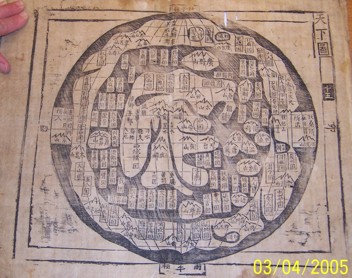
Here is a higher resolution of the featured map from the Harris Map Collection

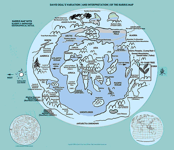
Below is a Variation (and Interpretation) of the above map by David Allen Deal

Posted on 10/21/2009 5:49:35 PM PDT by BGHater
Researcher whose father found old maps posits 2000 BC voyage to west coast
History books tell us that the first Chinese settlers to Canada arrived in Victoria about 150 years ago, but a U.S. researcher says she has solid evidence that they came earlier. Some 4,000 years earlier.
That would be 3,500 years before 1492, when European explorer Christopher "Columbus sailed the ocean blue."
Or 10,000 years after nomadic hunters from Eastern Siberia crossed the frozen Bering Strait during the Ice Age, a migration taken by modern scholars to account for North America's native population.
Charlotte Harris Rees, a retired civil servant from Virginia who came to her role as researcher late in life and rather accidentally, says she has proof the Chinese first sailed to the west coast of North and South America, or more specifically, were carried eastward on Pacific currents in 2,000 BC.
That explains, she says, why a number of placenames in the Americas mean something in Chinese, such as Peru, or "white mist," in Chinese, but not in Spanish.
And why certain symbols associated with Indian drawings found in America are nearly identical to Chinese writing; why native American infants share Asian babies' "Mongolian spots," a birthmark near the base of the spine, as well as Asian bloodlines and jawlines; and why ancient villages in China bear a resemblance to native American settlements, right down to the teepees.
Rees is scheduled to talk about her research in her second book on the subject, Secret Maps of the Ancient World, at Simon Fraser University's downtown campus Tuesday evening. Her major research source was her father, Dr. Hendon M. Harris Jr., a third-generation Chinese-born missionary who came across an ancient Chinese map in an antique shop in Korea in 1972. It showed major land masses such as Asia, India, Africa, Australia and Europe and also included North and South America, inscribed with the Chinese words Fu Sang, which the Chinese have long referred to as a mythical land to the east.
Drawing on these seven map books, which he matched to 23 others in collections around the world, he wrote a book called the Asiatic Fathers of America in 1973. It was largely ignored, and Harris died in 1981.
It wasn't until 2003 that Rees read a bestselling book by Gavin Menzies, a retired submarine commander living in London, and her interest was piqued. It claimed Chinese explorers in multi-storeyed and multi-masted ships beat Columbus to the New World by several decades. "After I read Gavin's book, I thought maybe there was something to what my father said," she said Saturday from Oregon, where she spoke to a packed audience at Portland State University.
Scholars have dismissed Menzies' book which, along with a second, similar book, has sold millions of copies.
But Rees endorses Menzies' work and the support is reciprocal. Rees, who hasn't sold many copies of her book or an earlier one that summarized her dad's research, isn't concerned about those who would pillory their work as fiction. "Any time you try to change history, there are going to be people who are going to resist it," she said.
She admitted she isn't an academic but said she draws on a variety of academic studies to prove her theory, a labour of love that consumes every day of what was supposed to be a quiet retirement. And she notes she has the endorsement of Dr. Hwa-Wei Lee, retired chief of the Asian division of the U.S. Library of Congress, who studied her dad's maps.
Here is a higher resolution of the featured map from the Harris Map Collection

Below is a Variation (and Interpretation) of the above map by David Allen Deal

Another BC thread, ping.
This site has some info and a photo of what may be ancient Chinese anchors in California.
http://www.cristobalcolondeibiza.com/2eng/2eng15.htm
Entirely possible. In fact I think the Americas were discovered multiple times.
Maybe, but how does it matter, other than for historical purposes?
I remember when I was visiting Yosemite and Sequoia National Parks many years ago, there was a plaque at one of those parks saying that Sequoia redwood trees only occur in three places on earth. One is central California (Yosemite and Sequoia National Parks), the other is Northern California and Southern Oregon, and the third is some place in China.
I wonder if early visitors to California brought back some cones or small trees to China?
Many people may have come here before Columbus, but he was the one developed permanent trading with the Americas. The world was a vastly different place after 10/12/1492, the same cannot be said of any previous visits from different explorers.
An interesting historical footnote, but that’s about it.
Entirely possible, the amusing thing is to hear from the ego/pride drive opinions that either support or deny these historical theories based on pre-conceived notions. Like the scientists who have the outcome of their experiments preordained in their construction.
Why not. But the Indians watched everybody come and go, come and go, until someone stayed. Chinese, Vikings, Kenyans, hello and goodbye.
We do know that at the time of the first Potrugese ships rounding the tip of africa the Chinese were there as well.
Nonsense. If one is navigating, i.e. traveling to a point represented on a chart or returning to a known location, a chronometer is an extremely valuable tool, but a calendar is useless. Polynesians successfully navigated the entire Pacific using nothing more than “stick maps” and a well developed lore. And to think that the Chinese were ignorant of astronomy and its usefulness is foolish.

Junk science?
Blam isn’t on this thread yet?? Huh??
CHILI PEPPERS"
The Chinese diet did not include hot sauces and peppers until they brought back chili pepeprs from Central American.
Agronomist have shown that while there were/are few cultivated peppers in the New World the Chinese grew and used selection techniques to produce over 500 varieties of hot peppers which were not of the New world but of Chinese invention. This is why much of their Southern cuisine is HOT!
Japan is labeled, 日本, just east of Korea. You can see that most everything is labeled a "country", 国. I'm not sure what the significance is of most of the notations, but along with the pictures of mountains, the character for mountain, 山, is quite prevalent.
How old is this map? The characters seem fairly modern to me.
|
|
|||
Gods |
Ooooh! Thanks BGHater! |
||
|
· Discover · Nat Geographic · Texas AM Anthro News · Yahoo Anthro & Archaeo · Google · · The Archaeology Channel · Excerpt, or Link only? · cgk's list of ping lists · |
|||

Disclaimer: Opinions posted on Free Republic are those of the individual posters and do not necessarily represent the opinion of Free Republic or its management. All materials posted herein are protected by copyright law and the exemption for fair use of copyrighted works.