Dramatic climate change caused by sudden tectonic uplift???

Posted on 06/11/2008 3:37:13 PM PDT by decimon
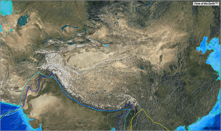
TALLAHASSEE, Fla. -- About 15,000 feet up on Tibet's desolate Himalayan-Tibetan Plateau, an international research team led by Florida State University geologist Yang Wang was surprised to find thick layers of ancient lake sediment filled with plant, fish and animal fossils typical of far lower elevations and warmer, wetter climates.
Back at the FSU-based National High Magnetic Field Laboratory, analysis of carbon and oxygen isotopes in the fossils revealed the animals' diet (abundant plants) and the reason for their demise during the late Pliocene era in the region (a drastic climate change). Paleo-magnetic study determined the sample's age (a very young 2 or 3 million years old).
That fossil evidence from the rock desert and cold, treeless steppes that now comprise Earth's highest land mass suggests a literally groundbreaking possibility:
Major tectonic changes on the Tibetan Plateau may have caused it to attain its towering present-day elevations -- rendering it inhospitable to the plants and animals that once thrived there -- as recently as 2-3 million years ago, not millions of years earlier than that, as geologists have generally believed. The new evidence calls into question the validity of methods commonly used by scientists to reconstruct the past elevations of the region.
"Establishing an accurate history of tectonic and associated elevation changes in the region is important because uplift of the Tibetan Plateau has been suggested as a major driving mechanism of global climate change over the past 50-60 million years," said Yang, an associate professor in FSU's Department of Geological Sciences and a researcher at the National High Magnetic Field Laboratory. "What's more, the region also is thought to be important in driving the modern Asian monsoons, which control the environmental conditions over much of Asia, the most densely populated region on Earth."
The fossil findings and implications are described in the June 15, 2008 issue of the peer-reviewed journal Earth and Planetary Science Letters. The journal can be accessed online at www.elsevier.com/locate/epsl.
Yang co-authored the paper ("Stable isotopes in fossil mammals, fish and shells from Kunlun Pass Basin, Tibetan Plateau: Paleoclimatic and paleoelevation implications") with paleontologists from the Department of Vertebrate Paleontology at the Natural History Museum of Los Angeles County, and the Institute of Vertebrate Paleontology and Paleoanthropology, Chinese Academy of Sciences (Beijing). The collaborative research project, which since 2004 has featured summer field study on the remote Tibetan Plateau, is funded by a grant from the Sedimentary Geology and Paleobiology Program of the U.S. National Science Foundation.
"The uplift chronology of the Tibetan Plateau and its climatic and biotic consequences have been a matter of much debate and speculation because most of Tibet's spectacular mountains, gorges and glaciers remain barely touched by man and geologically unexplored," Yang said.
"So far, my research colleagues and I have only worked in two basins in Tibet, representing a very small fraction of the Plateau, but it is very exciting that our work to-date has yielded surprising results that are inconsistent with the popular view of Tibetan uplift," she said.
This summer, Yang and her colleagues from Los Angeles and Beijing will conduct further fieldwork in areas near the Tibetan Plateau. "The next phase of our work will focus on examining the spatial and temporal patterns of long-term vegetative and environmental changes in and around the region," she said. "Such records are crucial for clarifying the linkages among climatic, biotic and tectonic changes."
There is much still to learn and understand about those changes.
"Many of the places we've visited in Tibet are now deserts, and yet we found those thick deposits of lake sediments with abundant fossil fish and shells," Yang said. "This begs the question: What came first and caused the disappearance of those lakes? Global climate change? Or, tectonic change?"
###
For more stories about FSU, visit our news site at www.fsu.com
Dramatic climate change caused by sudden tectonic uplift???
The answer may be on another continent — South America. The central Andes, too, are quite high and have an extremely high and dry plateau just east of their summits. And like Eurasia before the Indian plate plowed into it, there is no continent-on-continent collision in South America to explain the mountains and the plateau.
Instead, the Andes were built from the South American Plate riding over the thinner oceanic plates to the west. The crust in the collision zone crumpled and thickened — as in any crash — and now stands taller.
The Altiplano plateau to the east, however, might be made higher by something a bit more complex going on deep in the Earth, DeCelles explained.
It turns out that when the crust thickens, great pressures at the bottom can cause some minerals to rearrange their atoms into tighter-packed molecules. That makes a lot of rock denser than the hot mantle all around it, so it might peel away from the underside of the crust and sink into the mantle.
When that happens, hot mantle material surges up to fill the void — and the crust buoys higher. This not only encourages a plateau at the surface, but it triggers volcanic eruptions as well.
Of course, the new study is just one snapshot from one small part of the central Tibetan Plateau, Ritts cautions.
"It's still just a tiny area in a place that's twice the size of Texas," Ritts told Discovery News. "It's just the tip of the iceberg."

That makes sense, doesn’t it? A thicker, heavier plate rode over the top of a thinner, lighter one? Heh...
Evidence of a Genesis flood?
On the coast of Peru, 200 km from the capital Lima, lies the Pisco area. The Pacific Ocean borders the Pisco-Ica basin, a chain of 14 geological formations from 14 to 3.5 million years old, over a length of 200 km. This exceptional desert area was once part of the ocean floor. The land was pushed upwards by movements in the earth’s crust, and now sits about a hundred metres above sea level.
Along with the seabed the remains of millions of years of sea life have also been pushed up. This is why the area is exceptionally rich in fossils, which the wind gradually exposes in the shifting sands. Mario Urbina Schmitt and Rodolfo Salas Gismondi of the University of San Marcos in Lima and their team of palaeontologists have built up an extremely diverse collection of fossilised vertebrates. The finds include the fossilised skeletons of whales, seals, dolphins, turtles, sharks, penguins and even sloths, which swam around in the coastal water millions of years ago.

Distribution of fossil whales on Cerro Blanco, superimposed on an aerial photo. Red dots = individual whales (N = 180). Black dots = specimens that cannot be determined to be complete whales, usually because of post-exposure erosional damage (N = 166). It appears likely that most whales were essentially complete before the effects of modern erosion processes.

Baleen from Fernanda. Left - surface view of the baleen (~ 8 cm from top to bottom of photo). Upper right - cross section of baleen. The dark colored v-shaped structures are sheets of baleen. Lower right - microscopic enlargement of surface of a sheet of baleen. Notice the fine ridges preserved in the baleen. We found fossilized baleen in several other whales also, but the baleen was best preserved in this whale. This type of preservation requires rapid burial, before the baleen tissue decayed. Fernanda was also buried before the spinal cord decayed, as black mineral replacement of the spinal cord was present in its normal position within the vertebral column (but nowhere else).
-----
That makes sense, doesn’t it? A thicker, heavier plate rode over the top of a thinner, lighter one? Heh...
Yep, and the whales, seals, dolphins, turtles, sharks, penguins and even sloths, which swam around in the coastal water millions of years ago...all went along for the ride!
Innerstin stuff Fred. Why do I have this uneasy feeling that things are not exactly as they appear???
Try a little 'kitchen-physics' - uplift is due to magma - and as it cooled, just as a cake baked in the oven does, it sinks in the centre:
 It's known as the Taklimakan Desert. Looks like a lakebed to me...

The Altiplano, filled with water: Elevation 15,000 feet.

The suggestion that Lake Titicaca was lifted to its present elevation of 12,500 feet through some unspecified catastrophy was made by Velikovsky in "Earth in Upheaval" (1955). The archaeological record would have suggested that this would have happened in historic time, after Tiahuanaco was already built. But the archaeology of this site (built after 800 BC), the conditions of local agriculture (abondened terraces at the snow line, sterile conditions, "maize will not ripen"), or geological details (raised beaches, slanted strand lines, marine crustacians), cannot sustain this. It seems more reasonable to suggest that the Alto Plano and the Andes mountains were raised maybe 3000 or 4000 feet by the intrusion of magna below the established Cordilleras
What is more convincing is the occupation of the site at about 1400 BC and and a thorough exploitation of the available agricultural conditions...
Warning, graphics-heavy:
If you Google Earth Lake Titicaca, you will find huge areas of agricultural activities - now underwater:

Maybe it's jut me, but that statement seems to contradict itself -- unless the author assumes V's assertion(?) that the area was raised from roughly sea level???
I recall doing the Google Earth thing around this area several months back, for what reasons I can't recall; maybe an earlier FR thread. Was awestruck by it then; still am. Fascinating place. The parallel lines running sortof helter-skelter in some places is a puzzle though.
Thanks for all the links.
Disclaimer: Opinions posted on Free Republic are those of the individual posters and do not necessarily represent the opinion of Free Republic or its management. All materials posted herein are protected by copyright law and the exemption for fair use of copyrighted works.

