Posted on 01/13/2004 9:05:55 PM PST by petuniasevan
Discover the cosmos! Each day a different image or photograph of our fascinating universe is featured, along with a brief explanation written by a professional astronomer.
2004 January 14
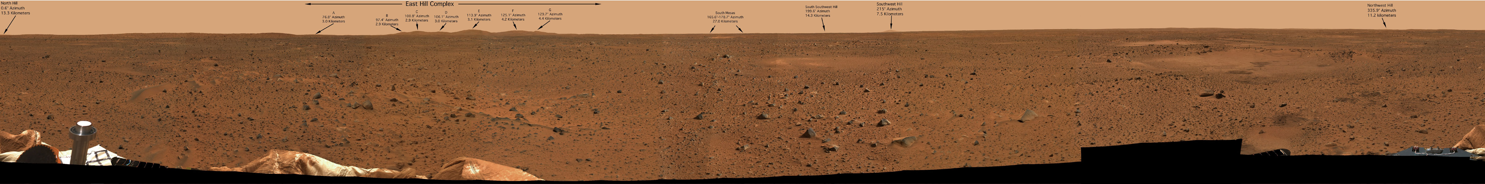
Explanation: If you could stand on Mars -- what would you see? Scrolling right will reveal a full color 360-degree panoramic view from NASA's Spirit Rover that landed on Mars just 10 days ago. The image is a digital mosaic from the panoramic camera that shows the view in every direction. Annotated on the image are the directions and distances to various hills along the horizon. These hills are valuable for orienting Spirit since they are also visible to the Mars Global Surveyor and Mars Odyssey spacecraft orbiting high overhead. Visible in the foreground are several instruments and airbags around Columbia Memorial Station. Spirit will attempt to roll onto the red planet in the next few days and explore interesting features.
 Spirit is headed toward the east hills. Credit: NASA/JPL/Cornell Download a larger version here. |
"This is a very carefully choreographed move around the lander," said flight director Chris Lewicki. "The most dangerous driving we're going to do on the surface is the first three meters. Our own lander is the most dangerous obstacle, so we need to be very careful in terms of getting off."
Once safely on the surface, the rover will stop and begin studying soil and rocks in the immediate vicinity.
Engineers and scientists now believe they know Spirit's location to within less than 100 feet. They have pinpointed the lander on the floor of Gusev Crater and, using a 360-degree panorama shot by Spirit's high-resolution camera system, they have developed an exploration strategy to answer a fundamental question: Did Gusev ever harbor a vast lake and if so, how long did it persist?
The panorama clearly shows the rim of the crater Spirit was drifting toward during its final descent, the one just 820 feet or so away. And off in the distance, a cluster of hills can be seen rising above the horizon. Both are prime scientific targets.
 This overhead view of the Mars Exploration Rover Spirit's estimated landing site and surrounding area shows the rover's potential travel plan -- a nearby crater and then a drive toward the east hills. Credit: NASA/JPL/MSSS |
"We know where we are now and we also know where we're going," Squyres said. "As would be the case with any explorers who have just gotten their bearings, thanks to the great work that the nav team and Tim Parker's colleagues have done, we now know where we are and with that knowledge, we can now intelligently plan a mission-long traverse, a mission-long plan for exploration of this landing site.
"Think back to what the objective is for this site. The goal at this site is to try to find materials that will tell us whether or not Gusev Crater once contained a lake and what the conditions were like in that lake. And what we have is, we have a broad, a vast plain of really very flat-lying materials. We'll soon know what the material we're perched on is like. As soon as we get down off the lander and start driving around, use the instruments on the (rover's robot) arm, use mini-TES (thermal emission spectrometer) to its fullest, we will know what the material we're on is like. But what lies beneath that? And what's higher up? Those are the questions we'd like to answer by traversing.
"So what we want to do, we want to go someplace where there's a big hole in the ground, find out what lies underneath our wheels, as deep as we can see, and then see what's up higher. ... Immediately to our northeast, at a distance of about 800 feet or so, 250 meters to the northeast, is a crater 200 meters in diameter. This is an extremely attractive target, it will have dug down to a depth of tens of meters, it will probably have a rim that might be three, four, five meters high, something like that. I don't know what we're going to do when we get there, OK? That's too far in the future. We will get there and we will see what we will see.
"But as we grow closer, we will go deeper and deeper into what geologists call the ejecta blanket, the stuff that was thrown out of the crater. So we'll see stuff that was excavated from 10, 20, 30 meters down beneath the surface. We'll be able to see that material. We'll drive up maybe to the lip of the crater, I don't know, we'll have to see how trafficable ... it is when we get there. But it will provide a window into the subsurface of Mars.
"Now once we have done our business at that crater - I don't know how long it's going to take to get there and I don't know how long we're going to explore once we do arrive, we will decide that as we go - after we've done that, we'll have seen as deep into Mars as we can ever hope to see on this mission. That's the biggest crater accessible to us. So then what do we do? We head up to those hills.
"Again, if you look at that image, there's an arrow pointing off towards the hills. I cannot tell you that we're going to reach those hills. This vehicle was designed, our requirement for how far we should be able to traverse over the course of the mission, was 600 meters. These hills are five times that far away. So don't sit here and think, 'oh, we're going to those hills.' We're going to go TOWARD the hills. But even as we do, the view will get better and better.
"This is what I feel is one of the most evocative images yet produced by this mission. This is the view from where we sit today of what we're currently calling the Eastern Hills. ... This is the direction that we're going to go, long term. And as the mission progresses, we will get closer and closer, the view will get better and better. We will be able to resolve new details on the hills with pancam, we will be able to measure their composition with increasing spatial resolution with mini-TES, we will get closer and closer to the hills and as we do, we will have a better and better chance of finding on the ground (material) that originated in the hills.
 The Eastern Hills in this Spirit image have been identified using orbiter imagery. Credit: NASA/JPL/MSSS Download a larger version here. |
"That's our long-term plan of exploration. It's one that I think is very rich in its scientific potential. It also offers a shared adventure that I think is unprecedented in human history. I think this is going to be a lot of fun."
  These maps shows the estimated location of the Mars Exploration Rover Spirit within Gusev Crater. Engineers targeted Spirit for the center of the blue ellipse. Measurements taken during the rover's descent by the Deep Space Network predicted its landing site to be the spot marked with a black dot. Later measurements taken on the ground by both the Deep Space Network and the orbiter Mars Odyssey narrowed the predicted landing site to a spot marked with a white dot. Credit: NASA/JPL/Arizona State University |

michael miserable failure moore hillary evil bitch clinton al sore loser gore bill lying rapist clinton
Disclaimer: Opinions posted on Free Republic are those of the individual posters and do not necessarily represent the opinion of Free Republic or its management. All materials posted herein are protected by copyright law and the exemption for fair use of copyrighted works.