Skip to comments.
Massive container ship loses power near NYC’s Verrazzano Bridge days after Baltimore Key Bridge disaster
New York Post ^
| 04/07/2024
| Chris Nesi
Posted on 04/07/2024 5:05:22 PM PDT by SeekAndFind
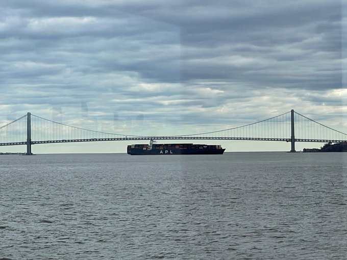
A massive container ship lost power in the waters around New York City and was brought to a rest near the Verrazzano-Narrows Bridge Friday night — less than two weeks after failure on another massive cargo vessel caused it to smash into Baltimore’s Francis Scott Key Bridge.
The US Coast Guard confirmed that its Vessel Traffic Service received a report that the 89,000-ton M/V Qingdao lost propulsion about 8:30 p.m. as it traversed Kill Van Kull waterway — the shipping lane between Staten Island and Bayonne, New Jersey.
An image shared on X by John Konrad, CEO of maritime-focused news outlet gCaptain, shows the 1,100-foot Qingdao floating uncomfortably close to the span that connects Brooklyn and Staten Island.
In response to the power failure, three tug boats were dispatched to bring the Qingdao under control.
The vessel was reportedly positioned “just north” of the bridge.
“Coast Guard Vessel Traffic Service New York received a report from the M/V Qingdao around 8:30pm, Saturday, that the vessel had experienced a loss of propulsion in the Kill Van Kull waterway,” a Coast Guard spokesperson told The Post in a statement Sunday.
“The vessel regained propulsion and was assisted to Stapleton Anchorage by tugs.”
(Excerpt) Read more at nypost.com ...
TOPICS: News/Current Events; US: New Jersey; US: New York; War
KEYWORDS: baltimorebridge; bridge; containership; enemyaction; newyork; newyorkcity; power; verrazanobridge; verrazzano; verrazzanobridge
Navigation: use the links below to view more comments.
first previous 1-20, 21-40, 41-60, 61-63 next last
To: gundog
41
posted on
04/07/2024 7:55:39 PM PDT
by
hal ogen
(First Amendment or Reeducation Camp??)
To: VTenigma
Concur. I bet chicoms are testing out electronic warfare. And maybe want to gum up key US ports before the Taiwan invasion.
Not a coincidence
To: drop 50 and fire for effect
YEAH; but if your the RED CHINKS you at least gotta try!
43
posted on
04/07/2024 9:24:58 PM PDT
by
5th MEB
(1)
To: RoseofTexas
They are already into WATER, ELECTRICAL, COMMUNICATION, and DISTRIBUTION systems, they just haven’t pulled the trigger yet!
44
posted on
04/07/2024 9:29:28 PM PDT
by
5th MEB
(1)
To: SeekAndFind
Nothing to see here. Walk away.
To: virgil
APL was originally American President Line, and all of their ships were named for American presidents. When APL went financially sour, the company was bought by Neptune Orient Line of Singapore.
It seems odd that CMA-CGM continues to use the APL prefix, particularly when what follows is the name of a port in China.
To: linMcHlp
Ashtabula is on lake Erie.
That’s the closest place???
47
posted on
04/08/2024 3:10:03 AM PDT
by
Blueflag
To: SeekAndFind; All
Check the fuel see if they are running bunker #2 fuel it could be tainted.
...............
https://www.marineinsight.com/guidelines/a-guide-to-marine-gas-oil-and-lsfo-used-on-ships/
General Problems Associated with MGO(mgo marine gas oil fills)
Microbial contamination, caused by bacteria and fungi, occurs in a fuel having water quantity. Due to bacterial presence, the fuel systems will generate problems such as chocked fuel filters and erratic engine operation. Possible microbiological contamination indicators are:
– Hazy appearance on the oil surface
– Suspended impurities in the oil
– Presence of the emulsion or a slimy interface layer between water and gas oil
– Foul smell from the tank drain with slight sludge discharge during draining operation
Fuel pumps of marine engines are designed for a minimum viscosity. The viscosity of Marine Gas Oil is very low as compared to the pump design factor which leads to inadequate hydrodynamic lubrication, causing wear and scuffing.
Related Read: Viscosity Meter and Viscosity Controller Used on Ships
A decrease in fuel viscosity may cause an increase in fuel leakage between the pump plunger and barrel.
The leakage can lead to a hot start, and low fuel setting starts difficulties, especially in worn fuel pumps.
Due to the low viscosity of the marine gas oil, the external and attached fuel pumps may not deliver the fuel at the required pressure, which will eventually hamper the designed power output of the engine.
....................
The more you look into it the more complex you see that fuel is a key ingredient in shipping and can be up to 35% of the cost of running big ships.
48
posted on
04/08/2024 3:31:57 AM PDT
by
rodguy911
(HOME OF THE FREE BECAUSE OF THE BRAVE!! ITS ALL A CONSPIRACY: UNTIL ITS NOT))
To: VTenigma
At least one of the investigations into what stopped the ship is fuel contamination. Another could be if the ship is run partially or entirely by computers. Who could hack it and is it even likely?
49
posted on
04/08/2024 3:34:14 AM PDT
by
rodguy911
(HOME OF THE FREE BECAUSE OF THE BRAVE!! ITS ALL A CONSPIRACY: UNTIL ITS NOT))
To: linMcHlp; All
American Mariner damaged after collision with light tower, St. Mary's River remains closed WCMU | By Rick Brewer
Published March 29, 2024 at 4:00 PM EDT

Shipping near the US-Canada border in the eastern Upper Peninsula remains at a standstill for the second day in a row.
The Coast Guard halted traffic on the St. Mary's River, as it investigates damage to a ship that struck a light tower early Thursday morning.
U.S. Coast Guard Air Station Travers City responds to the American Mariner marine casualty in Munuscong Lake, Michigan, March 28, 2024.
U.S. Coast Guard
U.S. Coast Guard Air Station Travers City responds to the American Mariner marine casualty in Munuscong Lake, Michigan, March 28, 2024.
The Coast Guard told WCMU the American Mariner sustained damage just below the ship's waterline after it slammed into the light tower. The tower is supposed to help ships navigate the waterway.
Lt. Phil Gurtler is a public affairs officer with the Coast Guard. He said the 714-foot bulk carrier is stable, and officials are not worried about the ship sinking at this point — but are hesitant to start moving it.
"We want to make sure that if we were to move it, (it wouldn't) make the the damage, we already know of, worse, or if there's more that we're not seeing," Gurtler said.
The Coast Guard has deployed an underwater drone to further examine the ship's hull. The Canadian Coast Guard has sent a cutter to provide support in Munuscong Lake, where the ship remains anchored.
Several bulk carriers are anchored on both sides of the St. Mary's River, which is the only shipping connection between Lake Superior and Lake Huron. It's still unclear when the waterway will re-open. Approximately 90% of the iron ore used to make steel in the US travels through the channel each year. Roughly 7,000 vessels pass through this area each shipping season.
The accident comes just days after an early start for the Great Lakes shipping season. Steel companies requested the Soo Locks open a few days ahead of schedule following a mild winter and delayed deliveries in January.
Eric Peace, vice president of the Lake Carriers' Association, a group that represents commercial shippers in the Great Lakes, said every hour ships don't move through the St. Mary's River, it costs shipping companies thousands of dollars.
Peace said the beginning of the shipping season is crucial for manufacturing plants across the Great Lakes region to replenish their inventory, after using their stock piles during the shipping season's winter recess. ....................
***linMcHlp by the way is an excellent poster when it comes to shipping he is very knowledgeable.
50
posted on
04/08/2024 3:43:58 AM PDT
by
rodguy911
(HOME OF THE FREE BECAUSE OF THE BRAVE!! ITS ALL A CONSPIRACY: UNTIL ITS NOT))
To: SeekAndFind
Everyone was ridiculing Lara Logan a couple weeks ago for saying that the Baltimore barge’s navigation systems had been hacked to purposely create that bridge disaster.
“Baltimore bridge collapse was an “absolutely brilliant strategic attack” on US critical infrastructure – most likely cyber...”
Maybe she ISN’T crazy.
51
posted on
04/08/2024 3:58:18 AM PDT
by
MayflowerMadam
(Navarro didn't kill himself.)
To: SeekAndFind; All
When you think about it all three of these “accidents” happened in areas of huge importance to major shipping links.
The great lakes is a huge shipping mecca as is the port at Baltimore and NYC. “Accidents” in or near all three could be suspect.
52
posted on
04/08/2024 3:58:27 AM PDT
by
rodguy911
(HOME OF THE FREE BECAUSE OF THE BRAVE!! ITS ALL A CONSPIRACY: UNTIL ITS NOT))
To: EnderWiggin1970
Bad fuel seems to be one of the bigger concerns. Wiring,computers,and human intervention could also be possible concerns.
53
posted on
04/08/2024 4:01:22 AM PDT
by
rodguy911
(HOME OF THE FREE BECAUSE OF THE BRAVE!! ITS ALL A CONSPIRACY: UNTIL ITS NOT))
To: MayflowerMadam; All
That's one of several possibilities that is looking more and more likely as we accumulate more and more ship crash data. We are quickly reaching a number of "accidenets" that might be beyond coincidence.
If so we have to evaluate what is going on. Cyber sabotage would be high on the list.
What I wonder about is could the same group that burned down chicken farm after farm now be attacking ships. Same who burn up forest after forest, many other coincidental happenings that might not be coincidental.
54
posted on
04/08/2024 7:41:54 AM PDT
by
rodguy911
(HOME OF THE FREE BECAUSE OF THE BRAVE!! ITS ALL A CONSPIRACY: UNTIL ITS NOT))
To: KingofZion
More likely Russia in response to the theater attack.
55
posted on
04/08/2024 8:04:27 AM PDT
by
VTenigma
(Conspiracy theory is the new "spoiler alert")
To: SeekAndFind
Perfect conspiracy story. I’m rushing out to buy more tinfoil - the old stuff is getting worn out.
56
posted on
04/08/2024 11:24:18 AM PDT
by
PIF
(They came for me and mine ... now its your turn)
To: rodguy911; rlmorel; spirited irish
Thanks, RG, but for the record, I am not an expert. What I try to do, is find info.
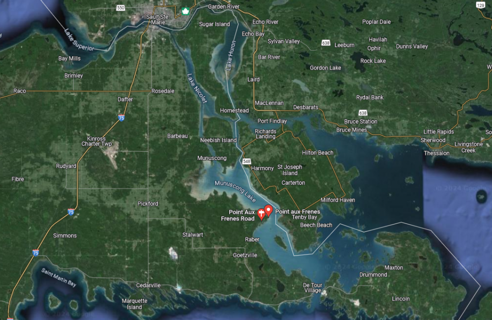
NauticalChartsOnline.com is down right now [20240408-135750 EDT Monday], so nautical charts 14883 and 14882 cannot be viewed online, there.
First Local News outlet "focusing on local news from Sault Ste. Marie Ontario and Michigan as well as district news in Algoma and the Upper Peninsula" . . . produced the following image:
- - -
For a closeup look, go to:
Office of Coast Survey - NOAA ENC Viewer
https://nauticalcharts.noaa.gov/enconline/enconline.html
Upper left area of the NOAA ENC Viewer, there is a data entry box. Enter: "Munuscong Lake"
Select: "Munuscong Lake, ON, CAN"
Munuscong Lake is the northern lake, and Mud Lake is the southern lake. They join at a relative "narrows" - that includes a navigable channel with a variety of navigation aids.
At the relative "narrows," to the west, is "Point aux Frenes," and to the east, "Hay Point" with a pair of "Hay Point Range" lights.
For a southbound freighter, the ship would approach the junction (the relative "narrows") by keeping itself aligned with the "Hay Point Range" front and rear lights/markers (large reflective panels).
On the ship's starboard bow, you find buoys 21 followed by 19 to the south-southeast from buoy 21.
On the ship's port bow, you find buoys 22 followed by 20 to the south-southeast from buoy 22, and then buoy 18 follows after 20.
Again (heading south), 21 then 19 on the starboard side, and 22, then 20, then 18 on the port side.
MV American Mariner lost control in the turn, while heading southbound and ran over, then stopped above, buoy 19 ("the light tower"):
12960 LIGHT 19
46-07-48.513N
084-01-00.655W
Fl G 2.5s [Flashing GREEN evey 2.5 seconds]
White cylindrical tower (33 ft) with GREEN band
- - -
57
posted on
04/08/2024 12:29:29 PM PDT
by
linMcHlp
To: rodguy911; rlmorel; spirited irish
NauticalChartsOnline.com, now working [20240408-1538 EDT Monday], so nautical charts
14883 and
14882 can be viewed online, there.
58
posted on
04/08/2024 12:39:02 PM PDT
by
linMcHlp
To: linMcHlp
so for others not nautically savvy the ship lost control at a key area for shipping both north and south right?
59
posted on
04/09/2024 3:56:13 AM PDT
by
rodguy911
(HOME OF THE FREE BECAUSE OF THE BRAVE!! ITS ALL A CONSPIRACY: UNTIL ITS NOT))
To: rodguy911
60
posted on
04/09/2024 9:45:39 AM PDT
by
linMcHlp
Navigation: use the links below to view more comments.
first previous 1-20, 21-40, 41-60, 61-63 next last
Disclaimer:
Opinions posted on Free Republic are those of the individual
posters and do not necessarily represent the opinion of Free Republic or its
management. All materials posted herein are protected by copyright law and the
exemption for fair use of copyrighted works.
FreeRepublic.com is powered by software copyright 2000-2008 John Robinson